File:FAA JFK Airport map 2011.svg
পরিভ্রমণে চলুন
অনুসন্ধানে চলুন

এই SVG ফাইলের জন্য এই PNG প্রাকদর্শনের আকার: ৩৯০ × ৫৯৯ পিক্সেল। অন্যান্য আকারসমূহ: ১৫৬ × ২৪০ পিক্সেল | ৩১২ × ৪৮০ পিক্সেল | ৫০০ × ৭৬৮ পিক্সেল | ৬৬৭ × ১,০২৪ পিক্সেল | ১,৩৩৪ × ২,০৪৮ পিক্সেল | ৬০৫ × ৯২৯ পিক্সেল।
মূল ফাইল (এসভিজি ফাইল, সাধারণত ৬০৫ × ৯২৯ পিক্সেল, ফাইলের আকার: ১.৩৬ মেগাবাইট)
ক্যাপশনসমূহ
ক্যাপশন
এই ফাইল কি প্রতিনিধিত্ব করছে তার এক লাইন ব্যাখ্যা যোগ করুন

সারাংশ
[সম্পাদনা]
| বিবরণ |
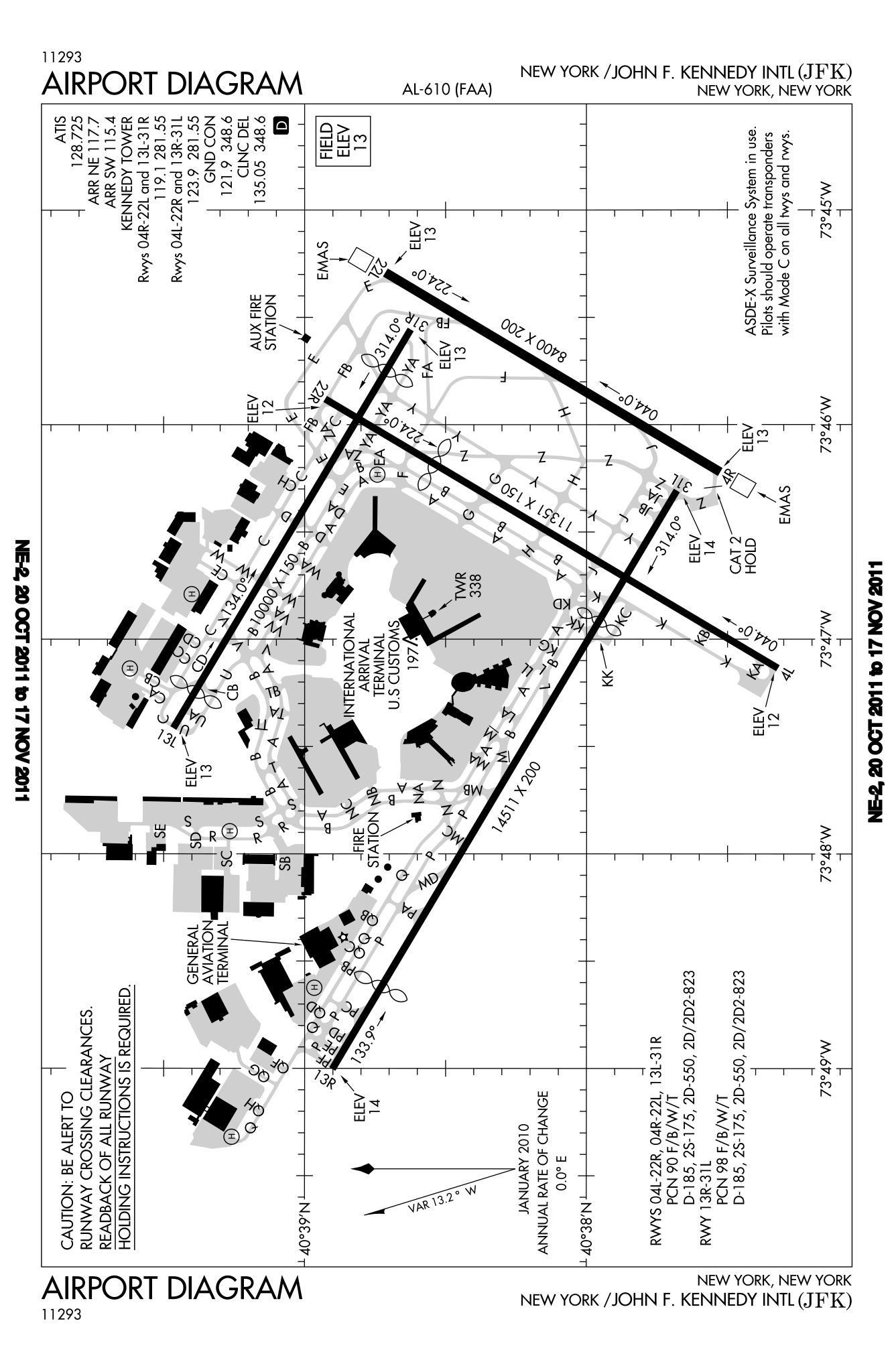
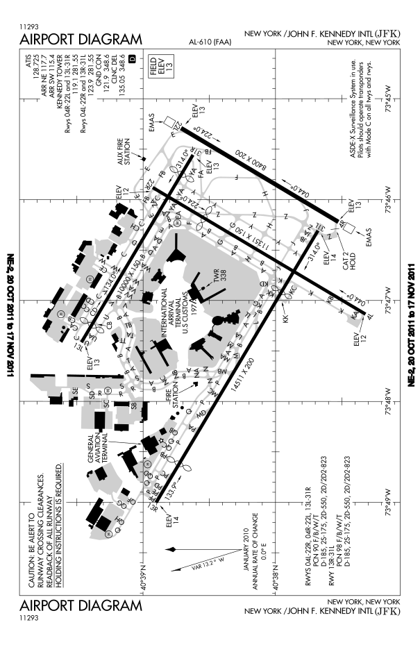
English: FAA diagram for John F. Kennedy International Airport in Queens, New York, United States. |
| তারিখ | |
| উৎস |
Website: http://www.avn.faa.gov/digital_tpp.asp Image: http://www.avn.faa.gov/d-tpp/0812/00610AD.PDF (changes every 28 days, see article for current link) |
| লেখক | National Aeronautical Charting Office (NACO), a department of the U.S. Federal Aviation Administration (FAA). |
| অনুমতি (এ ফাইলের পুনঃব্যবহার) |
Public Domain |
লাইসেন্স প্রদান
[সম্পাদনা]
This image or file is a work of a Federal Aviation Administration employee, taken or made as part of that person's official duties. As a work of the U.S. federal government, the image is in the public domain in the United States.
|
 |
ফাইলের ইতিহাস
যেকোনো তারিখ/সময়ে ক্লিক করে দেখুন ফাইলটি তখন কী অবস্থায় ছিল।
| তারিখ/সময় | সংক্ষেপচিত্র | মাত্রা | ব্যবহারকারী | মন্তব্য | |
|---|---|---|---|---|---|
| বর্তমান | ২২:৪৬, ২০ অক্টোবর ২০১১ | | ৬০৫ × ৯২৯ (১.৩৬ মেগাবাইট) | Bluefist (আলোচনা | অবদান) | New version as of October 20, 2011. |
| ২১:৩৯, ১ মার্চ ২০১০ |  | ৪৮৪ × ৭৪৩ (৭০৯ কিলোবাইট) | Atmoz (আলোচনা | অবদান) | upload new version | |
| ২৩:২৯, ১৩ নভেম্বর ২০০৮ |  | ৩৭৯ × ৫৭৬ (৭৬০ কিলোবাইট) | Phongn (আলোচনা | অবদান) | {{Information |Description={{en|1=FAA diagram of JFK.}} |Source=http://www.avn.faa.gov/digital_tpp.asp |Author=Federal Aviation Administration |Date= |Permission= |other_versions= }} <!--{{ImageUpload|full}}--> |
আপনি এই ফাইলটি প্রতিস্থাপন করতে পারবেন না।
ফাইলের ব্যবহার
নিম্নলিখিত পাতাটি এই ফাইল ব্যবহার করে:
- File:00610AD.svg (ফাইল পুনঃর্নিদেশ)
ফাইলের বৈশ্বিক ব্যবহার
নিচের অন্যান্য উইকিগুলো এই ফাইলটি ব্যবহার করে:
- bn.wikipedia.org-এ ব্যবহার
- en.wikipedia.org-এ ব্যবহার
- ko.wikipedia.org-এ ব্যবহার
- ms.wikipedia.org-এ ব্যবহার
- ta.wikipedia.org-এ ব্যবহার
- th.wikipedia.org-এ ব্যবহার
- uk.wikipedia.org-এ ব্যবহার