File:FGC 254.01 Callús (14007740246).jpg

Original file (1,270 × 699 pixels, file size: 559 KB, MIME type: image/jpeg)
Captions
Captions
Summary[edit]
.jpg&action=edit§ion=1)
| Description |
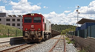
[CAT]: Després dels fracassos que vaig tenir el dia anterior, -el saler de pujada em va donar temps a tant sols fer-li una miserable foto testimonial i el de baixada em va passar per davant meu sense temps a res mes, tot i que l'objectiu principal del dia era la potassa de Sallent, que potser algun dia us expliqui la desventura- vaig decidir anar de nou a per el saler a veure si tenia millor sort. La primera intenció era fer la foto a Pineda de Bages, però vaig arribar tard, ja que al passar-me per el triangle de Manresa-Alta aquest ja estava sortint i no tenia temps material de realitzar la foto que tenia al cap. Així que va tocar canvi de plans, a Callús sí que em donava temps a arribar i així esmenava el fracàs del dia anterior, tot i sabent que ni en el de pujada ni en el de baixada no tindrien a l'astre rei a favor. Així que va ser arribar i moldre, a la foto la 254.01 pujant el saler vespertí, passant per la població de Callús, on està ubicat l'únic tram de doble via -on no hi caben ni el saler ni la potassa-, el qual s'utilitzava com a plataforma de sortida del <a href="http://www.elcardener.com/Activitats/Ecorail_del_Cardener.htm" rel="nofollow">Ecorail del Cardener</a>. [ES]: Después de los esquinazos que me dió el día anterior, -el salero de subida me dió tiempo a tan solo hacerle una mísera foto testimonial y el de bajada me pasó por delante de mis morros sin tiempo a nada, aunque el objetivo principal del día era la potasa de Sallent, que quizás algún día os cuente la aventura- decidí ir de nuevo a por el salero a ver si tenía mejor suerte. La intención inicial era hacerle foto en Pineda de Bages, pero llegué tarde, ya que al pasarme por el triángulo de Manresa-Alta este ya estaba saliendo y no tenía tiempo material de realizar la foto que tenía en mente. Así que cambio de planes, a Callús sí que me daba tiempo a llegar y así me sacaba la espinita del día anterior, aún sabiendo que ni en el de subida ni en el de bajada no tendrían al astro rey a favor. Así que fué llegar y besar el santo, en la foto la 254.01 subiendo el salero vespertino, pasando por la población de Callús, donde está ubicado el único tramo de doble vía -donde no caben ni el salero ni la potasa-, el cual se usaba como plataforma de salida del <a href="http://www.elcardener.com/Activitats/Ecorail_del_Cardener.htm" rel="nofollow">Ecorail del Cardener</a>. |
| Date | |
| Source | FGC 254.01 Callús |
| Author | eldelinux from Cataluña, España |
| Camera location | | View this and other nearby images on: OpenStreetMap |
|---|
.jpg¶ms=041.782521_N_0001.785449_E_globe:Earth_type:camera_source:Flickr_&language=en)
Licensing[edit]
.jpg&action=edit§ion=2)
- You are free:
- to share – to copy, distribute and transmit the work
- to remix – to adapt the work
- Under the following conditions:
- attribution – You must give appropriate credit, provide a link to the license, and indicate if changes were made. You may do so in any reasonable manner, but not in any way that suggests the licensor endorses you or your use.
| This image was originally posted to Flickr by eldelinux at https://flickr.com/photos/28528041@N05/14007740246 (archive). It was reviewed on 18 May 2018 by FlickreviewR 2 and was confirmed to be licensed under the terms of the cc-by-2.0. |
File history
Click on a date/time to view the file as it appeared at that time.
| Date/Time | Thumbnail | Dimensions | User | Comment | |
|---|---|---|---|---|---|
| current | 12:41, 18 May 2018 | | 1,270 × 699 (559 KB) | OceanAtoll (talk | contribs) | Transferred from Flickr via #flickr2commons |
You cannot overwrite this file.
File usage on Commons
There are no pages that use this file.
File usage on other wikis
The following other wikis use this file:
- Usage on ca.wikipedia.org
.jpg&oldid=516889462)