File:FHWA Auxiliary Route Numbering Diagram.svg
跳转到导航
跳转到搜索

此SVG文件的PNG预览的大小:800 × 320像素。 其他分辨率:320 × 128像素 | 640 × 256像素 | 1,024 × 410像素 | 1,280 × 512像素 | 2,560 × 1,024像素 | 1,000 × 400像素。
原始文件 (SVG文件,尺寸为1,000 × 400像素,文件大小:127 KB)
说明
说明
添加一行文字以描述该文件所表现的内容
摘要
[编辑]
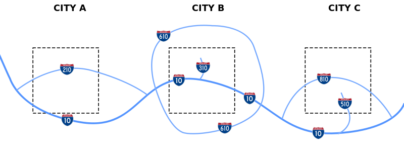
| 描述 | Diagram of how the FHWA assigns numbers to different types of interstate routes |
| 日期 | |
| 来源 | 自己的作品 |
| 作者 | Stratosphere |
| 授权 (二次使用本文件) |
Public Domain |
许可协议
[编辑]
我,本作品著作权人,特此采用以下许可协议发表本作品:
| 本作品采用知识共享CC0 1.0 通用公有领域贡献许可协议授权。 | |
| 采用本宣告发表本作品的人,已在法律允许的范围内,通过在全世界放弃其对本作品拥有的著作权法规定的所有权利(包括所有相关权利),将本作品贡献至公有领域。您可以复制、修改、传播和表演本作品,将其用于商业目的,无需要求授权。
|
文件历史
点击某个日期/时间查看对应时刻的文件。
| 日期/时间 | 缩略图 | 大小 | 用户 | 备注 | |
|---|---|---|---|---|---|
| 当前 | 2008年2月18日 (一) 09:56 | 1,000 × 400(127 KB) | Stratosphere(留言 | 贡献) | ||
| 2008年2月18日 (一) 09:53 | 1,000 × 400(21 KB) | Stratosphere(留言 | 贡献) | |||
| 2008年2月18日 (一) 09:47 | 1,000 × 400(8 KB) | Stratosphere(留言 | 贡献) | |||
| 2008年2月18日 (一) 09:43 | 1,000 × 400(7 KB) | Stratosphere(留言 | 贡献) | |||
| 2008年2月18日 (一) 09:41 | 1,000 × 400(10 KB) | Stratosphere(留言 | 贡献) | {{Information |Description=Diagram of how the FHWA assigns numbers to different types of interstate routes |Source=self-made |Date=February 18, 2008 |Author= Stratosphere |Permission=Public Domain |other_versions= }} |
您不可以覆盖此文件。
文件用途
以下页面使用本文件:
全域文件用途
以下其他wiki使用此文件:
- en.wikipedia.org上的用途
- es.wikipedia.org上的用途
- fr.wikipedia.org上的用途
- he.wikipedia.org上的用途
- it.wikipedia.org上的用途
- pt.wikipedia.org上的用途
- ru.wikipedia.org上的用途
- uk.wikipedia.org上的用途
- vi.wikipedia.org上的用途
- zh.wikipedia.org上的用途