File:FLN soccer team visited countries.png
Jump to navigation
Jump to search
No higher resolution available.
FLN_soccer_team_visited_countries.png (695 × 354 pixels, file size: 41 KB, MIME type: image/png)
Captions
Captions
Add a one-line explanation of what this file represents
| Description |
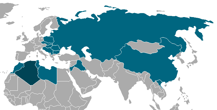
Français : Carte montrant les pays dans lesqulles l'équipe du FLN de football est passé durant sa tournée entre 1958 et 1962. |
| Date | (UTC) |
| Source | |
| Author |
|
| This is a retouched picture, which means that it has been digitally altered from its original version. The original can be viewed here: BlankMap-World-1962.png:
|
I, the copyright holder of this work, hereby publish it under the following licenses:
| This file is licensed under the Creative Commons Attribution-Share Alike 3.0 Unported license. | ||
| ||
| This licensing tag was added to this file as part of the GFDL licensing update. |

|
Permission is granted to copy, distribute and/or modify this document under the terms of the GNU Free Documentation License, Version 1.2 or any later version published by the Free Software Foundation; with no Invariant Sections, no Front-Cover Texts, and no Back-Cover Texts. A copy of the license is included in the section entitled GNU Free Documentation License. |
You may select the license of your choice.
Original upload log[edit]
This image is a derivative work of the following images:
- File:BlankMap-World-1962.png licensed with Cc-by-sa-3.0-migrated, GFDL
- 2007-09-24T02:49:22Z Hoshie 1357x628 (49120 Bytes) put the (N/S) Yemen boundary in white due to the fact the boundaries in southern Saudi Arabia have been disputed, undemarcated, or undisclosed over the years.
- 2007-08-06T00:43:46Z Hoshie 1357x628 (49165 Bytes) Added Cabinda; under same lic. as original.
- 2007-01-28T10:27:46Z Hoshie 1357x628 (49159 Bytes) added Ifni, a Spanish enclave.
- 2007-01-05T23:54:02Z Roke 1357x628 (49104 Bytes) Blank world map with 1962 borders. This is accurate between December 19, 1961 (India takes over the Portugese colony of Goa) and July 1, 1962 (Belgian colony of Ruanda-Urundi separated into Rwanda and Burundi.) See [[w:List o
Uploaded with derivativeFX
File history
Click on a date/time to view the file as it appeared at that time.
| Date/Time | Thumbnail | Dimensions | User | Comment | |
|---|---|---|---|---|---|
| current | 20:24, 8 April 2010 | | 695 × 354 (41 KB) | Clapsus (talk | contribs) | recadrage |
| 19:54, 8 April 2010 |  | 1,357 × 628 (52 KB) | Clapsus (talk | contribs) | +Irak+Joradanie | |
| 19:49, 8 April 2010 |  | 1,357 × 628 (51 KB) | Clapsus (talk | contribs) | {{Information |Description={{fr|Carte montrant les pays dans lesqulles l'équipe du FLN de football est passé durant sa tournée entre 1958 et 1962.}} |Source=*File:BlankMap-World-1962.png |Date=2010-04-08 19:44 ( |
You cannot overwrite this file.
File usage on Commons
There are no pages that use this file.
File usage on other wikis
The following other wikis use this file:
- Usage on ar.wikipedia.org
- Usage on de.wikipedia.org
- Usage on fr.wikipedia.org