File:Fascist concentration camps in yugoslavia-sr.png
Aller à la navigation
Aller à la recherche
Taille de cet aperçu : 506 × 600 pixels. Autres résolutions : 202 × 240 pixels | 405 × 480 pixels | 648 × 768 pixels | 1 076 × 1 275 pixels.
Fichier d’origine (1 076 × 1 275 pixels, taille du fichier : 190 kio, type MIME : image/png)
Légendes
Légendes
Ajoutez en une ligne la description de ce que représente ce fichier
Description[modifier]
| Description |
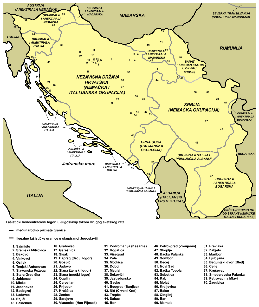
English: Fascist concentration camps in Yugoslavia in World War II - Serbian language version. Српски / srpski: Fašistički koncentracioni logori u Jugoslaviji tokom Drugog svetskog rata - verzija na srpskom jeziku. |
| Source | Travail personnel |
| Auteur | PANONIAN |
Conditions d’utilisation[modifier]
self-made map by user:PANONIAN
| Moi, propriétaire des droits d’auteur sur cette œuvre, la place dans le domaine public. Ceci s'applique dans le monde entier. Dans certains pays, ceci peut ne pas être possible ; dans ce cas : J’accorde à toute personne le droit d’utiliser cette œuvre dans n’importe quel but, sans aucune condition, sauf celles requises par la loi. |
References[modifier]
Map is primarily based on this source:
- Istorijski atlas, Geokarta, Beograd, 1999.
Other secondary sources:
- Valter Manošek, Holokaust u Srbiji, Beograd, 2007.
- Dr Rajko Đurić - Mr Antun Miletić, Istorija holokausta Roma, Beograd, 2008.
- http://www.terra.es/personal7/jqvaraderey/194145fc.gif - Map of fascist Europe (1941-1945)
- http://www.geschichteinchronologie.ch/eu/jugoland/EncJud_juden-im-jugoland-03-holocaust-1941-1944-ENGL.html - Jews in Yugoslavia 03: Holocaust 1941-1944
- http://www.open.ac.uk/socialsciences/semlin/sr/holokaust-u-srbiji.php - Holokaust u okupiranoj Srbiji
- http://www.jerusalim.org/cd/jasenovac/index_en.html - Concentration and Death Camp Jasenovac
- http://www.jobeograd.org/index.php?option=com_content&view=article&id=66&Itemid=111 - Holocaust in Belgrade
Historique du fichier
Cliquer sur une date et heure pour voir le fichier tel qu'il était à ce moment-là.
| Date et heure | Vignette | Dimensions | Utilisateur | Commentaire | |
|---|---|---|---|---|---|
| actuel | 17 octobre 2011 à 13:12 | | 1 076 × 1 275 (190 kio) | PANONIAN (d | contributions) | corrections |
| 31 octobre 2010 à 19:03 |  | 1 076 × 1 275 (178 kio) | PANONIAN (d | contributions) | minor corrections | |
| 30 octobre 2010 à 19:38 |  | 1 076 × 1 275 (179 kio) | PANONIAN (d | contributions) | {{Information |Description={{en|1=Fascist concentration camps in Yugoslavia in World War II - Serbian language version.}} |Source={{own}} |Author=PANONIAN |Date= |Permission= |other_versions= }} |
Vous ne pouvez pas remplacer ce fichier.
Utilisations locales du fichier
Aucune page n’utilise ce fichier.
Utilisations du fichier sur d’autres wikis
Les autres wikis suivants utilisent ce fichier :
- Utilisation sur ba.wikipedia.org
- Utilisation sur be-tarask.wikipedia.org
- Utilisation sur en.wikipedia.org
- Utilisation sur fr.wikipedia.org
- Utilisation sur hr.wikipedia.org
- Utilisation sur it.wikipedia.org
- Utilisation sur pt.wikipedia.org
- Utilisation sur ru.wikipedia.org
- Utilisation sur sh.wikipedia.org
- Utilisation sur sr.wikipedia.org
- Влада народног спаса
- Историја Републике Српске
- Концентрациони логор
- Концентрациони логори у НДХ
- Геноцид над Србима у Другом свјетском рату
- Хронологија геноцида над Србима у Другом свјетском рату
- Јевреји у Србији
- Дрита Тутуновић
- Логори Нацистичке Немачке у Србији
- Геноцид над Србима у Независној Држави Хрватској
- Холокауст у окупираној Србији
- Страдања јеврејских здравствених радника током Другог светског рата у Југославији
- Utilisation sur uz.wikipedia.org
Catégories :
- Maps of Yugoslavia during World War II
- Maps of Serbia during World War II
- Maps of Montenegro during World War II
- Maps of the Independent State of Croatia
- Maps of the history of Vojvodina
- Maps of the history of Banat
- Maps of the history of Bačka
- Maps of the history of Syrmia
- Maps of Bosnia and Herzegovina during World War II
- Maps of the history of North Macedonia in modern times
- Maps of World War II in Slovenia
- Maps of the Holocaust
- The Holocaust in Yugoslavia
- Concentration camps
- Banat (1941-1944)
- Serbian-language maps