File:Federal Republic of Central America (orthographic projection).svg
Pāriet uz navigāciju
Pāriet uz meklēšanu

Size of this PNG preview of this SVG file: 550 × 550 pikseļi. Citi izmēri: 240 × 240 pikseļi | 480 × 480 pikseļi | 768 × 768 pikseļi | 1 024 × 1 024 pikseļi | 2 048 × 2 048 pikseļi.
Sākotnējais fails (SVG fails, definētais izmērs 550 × 550 pikseļi, faila izmērs: 86 KB)
Captions
Captions
Pievieno vienas rindiņas aprakstu, ko šis fails attēlo
Kopsavilkums[labot šo sadaļu]
| Apraksts |
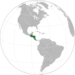
English: An orthographic projection of the Federal Republic of Central America (1823–1839/1841); controlled territories in dark green, claimed but uncontrolled territories (Belize and the Mosquito Coast) in light green Español: Una proyección ortográfica de la República Federal de Centro América; territorios controlados en verde oscuro, territorios reclamados pero no controlados (Belice y la Costa de Mosquitos) en verde claro |
||||||
| Datums | |||||||
| Avots |
Paša darbs
|
||||||
| Autors | Heraldry | ||||||
| Atļauja: (Šī faila izmantošana citur) |
|
||||||
| Citas versijas |
.svg) |
||||||
| SVG veidošana |

.svg)
.svg)
.svg)
.svg)
.svg)
.svg)
.svg)
.svg)
.svg)
.svg)
.svg)
.svg)
.svg)
.svg)
.svg)
.svg)
.svg)
.svg)
.svg)
.svg)
.svg)
.svg)
.svg)
.svg)
.svg)
.svg)
.svg)
.svg)
.svg)
.svg)
.svg)
.svg)
.svg)
.svg)
.svg)
.svg)
.svg)
.svg)
.svg)
.svg)
.svg)
.svg)
.svg)
.svg)
.svg)
.svg)
.svg)
.svg)
.svg)
.svg)
.svg)
.svg)
.svg)
.svg)
.svg)
.svg)
.svg)
.svg)
.svg)
.svg)
.svg)
.svg)
.svg)
.svg)
.svg)
.svg)
.svg)
.svg)
.svg)
.svg)
.svg)
.svg)
.svg)

.svg)

.svg)

.svg)
.svg)
.svg)
.svg)
.svg)
.svg)
.svg)


.svg)
.svg)
.svg)
.svg)
.svg)
.svg)
.svg)

.svg)
.svg)
.svg)
.svg)
.svg)
.svg)
.svg)
.svg)
.svg)
.svg)

.svg)
.svg)
.svg)
.svg)
.svg)
.svg)
.svg)
_without_national_boundaries.svg)
.svg)
.svg)
.svg)
.svg)
.svg)
.svg)

.svg)
.svg)
.png)
.svg)
.svg)
.svg)
.svg)

.svg)
.svg)
.svg)
.svg)
.svg)
.svg)
.svg)
.svg)
.svg)
.svg)
.svg)

.svg)
.svg)
.svg)
.svg)
.svg)
.svg)
.svg)
.svg)
.svg)

.svg)
.svg)

.svg)
.svg)
.svg)
.svg)
.svg)
.svg)
.svg)
.svg)
.svg)
.svg)
.svg)
.svg)
.svg)
.svg)
.svg)
.svg)
.svg)
.svg)
.svg)
.svg)
.svg)
.svg)
.svg)
.svg)
.svg)
.svg)
.svg)
_-_Crimea_disputed.svg)
.svg)
.svg)
.svg)
.svg)
.svg)
.svg)
.svg)
.svg)
.svg)
.svg)
.svg)
_political.svg)
.svg)
.svg)
.svg)
.svg)
_-_Crimea_disputed_-_no_borders.svg)
.svg)
.svg)
.svg)
.svg)
.svg)
.svg)
.svg)
.svg)
.svg)
.svg)
.svg)

.svg)
.svg)
.svg)

.png)
.svg)
.svg)
.svg)
.svg)
.svg)
.svg)
.svg)
.svg)
.svg)
.svg)
.svg)
.svg)
.svg)
.svg)
.svg)
.svg)
.svg)
.svg)
.svg)
.svg)
.svg)
.svg)
.svg)
.svg)
.svg)
.svg)
.svg)
.svg)
.svg)
.svg)
.svg)
.svg)
.svg)
.svg)
.png)
.svg)
.svg)
.svg)
_(orthographic_projection).png)
.svg&action=edit§ion=1)
.svg)
.svg)
.svg)
.svg)
Licence[labot šo sadaļu]
.svg&action=edit§ion=2)
Es, šī darba autortiesību īpašnieks, publicēju to saskaņā ar šo licenci:

|
Ir dota atļauja kopēt, izplatīt un/vai pārveidot šo dokumentu saskaņā ar GNU brīvās dokumentācijas licences, versijas 1.2 vai jebkuras vēlākas versijas, ko publiskojis Brīvās programmatūras fonds nosacījumiem; bez nemainīgajām sadaļā, priekšējā un aizmugurēja'vāka tekstiem. Licences kopija ir iekļauta sadaļā ar nosaukumu GNU brīvās dokumentācijas licence. |
| Šis fails tiek izplatīts saskaņā ar licences Creative Commons Atsauce-Līdzīgi Noteikumi 3.0 Vispārējiem noteikumiem. | ||
| ||
| This licensing tag was added to this file as part of the GFDL licensing update. |
Faila hronoloģija
Uzklikšķini uz datums/laiks kolonnā esošās saites, lai apskatītos, kā šis fails izskatījās tad.
| Datums/Laiks | Attēls | Izmēri | Dalībnieks | Komentārs | |
|---|---|---|---|---|---|
| tagadējais | 2024. gada 28. aprīlis, plkst. 19.44 | | 550 × 550 (86 KB) | PizzaKing13 (diskusija | devums) | error |
| 2024. gada 25. aprīlis, plkst. 22.30 |  | 550 × 550 (86 KB) | PizzaKing13 (diskusija | devums) | changed borders per sources | |
| 2012. gada 12. septembris, plkst. 20.44 |  | 550 × 550 (75 KB) | Palosirkka (diskusija | devums) | Scrubbed with http://codedread.com/scour/ | |
| 2010. gada 30. marts, plkst. 23.57 |  | 550 × 550 (342 KB) | Milenioscuro (diskusija | devums) | fixed South American and African country borders | |
| 2009. gada 5. decembris, plkst. 02.08 |  | 550 × 550 (352 KB) | Keepscases (diskusija | devums) | borders | |
| 2009. gada 4. septembris, plkst. 23.27 |  | 541 × 541 (350 KB) | TownDown (diskusija | devums) | {{Information |Description={{en|1=l}} |Source=Own work by uploader |Author=TownDown |Date= |Permission= |other_versions= }} Category:x |
Šo failu nevar pārrakstīt.
Faila lietojums
Šo failu izmanto vairāk nekā 100 lapās. Šajā sarakstā ir tikai pirmās 100 lapas, kas izmanto šo failu. Pieejams arī pilns saraksts.
.svg)
- Grey–green orthographic projections maps
- User:Heraldry/Central America
- User:Heraldry/Files
- User:Heraldry/Projections
- User:Ssolbergj/orthographic
- User:TownDown/Projections
- User:TownDown/Projections B
- File:ALBA (orthographic projection).png
- File:Africa (orthographic projection).svg
- File:African Union (orthographic projection).svg
- File:Almoravid map.svg
- File:America do Sul (orthographic projection).jpg
- File:Americas (orthographic projection).svg
- File:Andean Community (orthographic projection).svg
- File:Antarctica (orthographic projection).svg
- File:Antillas (orthographic projection).svg
- File:Arctic (orthographic projection).svg
- File:Argentina (orthographic projection).png
- File:Argentina (orthographic projection).svg
- File:Aridoamerica (orthographic projection).svg
- File:Asia (orthographic projection).svg
- File:Association of Southeast Asian Nations (orthographic projection).svg
- File:Australia-New Guinea (orthographic projection).svg
- File:Australia (orthographic projection).svg
- File:Australia map with outlying islands.svg
- File:Brazil (orthographic projection).svg
- File:Canada (orthographic projection).svg
- File:Central America (orthographic projection).svg
- File:Central Asia (orthographic projection).svg
- File:Chile (orthographic projection).svg
- File:Coat of arms of the Federal Republic of Central America.svg
- File:Coat of arms of the United Provinces of Central America.svg
- File:Colombia (orthographic projection).svg
- File:Dominion of Pakistan & Indian Controlled Kashmir (orthographic projection).svg
- File:East Asia (orthographic projection).svg
- File:Ecuador (orthographic projection).svg
- File:Europe (orthographic projection).svg
- File:European Union (orthographic projection).svg
- File:Federal Republic of Central America (orthographic projection).svg
- File:First Brazilian Empire (orthographic projection).svg
- File:First Mexican Empire (orthographic projection).svg
- File:Flag of British Honduras (1919–1981).svg
- File:Flag of Costa Rica (1838-1840).svg
- File:Flag of El Salvador (1839-1865).svg
- File:Flag of Guatemala (1838-1843).svg
- File:Flag of Guatemala (1839-1843).svg
- File:Flag of Honduras (1839-1866).svg
- File:Flag of Los Altos.svg
- File:Flag of Nicaragua (1839-1858).svg
- File:Flag of the Central American Integration System.svg
- File:Flag of the Federal Republic of Central America.svg
- File:Flag of the Province of Chiapas.svg
- File:Flag of the United Provinces of Central America.svg
- File:Georgia (orthographic projection).svg
- File:Global European Union.svg
- File:Great Colombia (orthographic projection).svg
- File:Greater Middle East (orthographic projection).svg
- File:India (orthographic projection).svg
- File:Indonesia (orthographic projection).svg
- File:Iran (orthographic projection).svg
- File:Iraq (orthographic projection).svg
- File:Japan (orthographic projection).svg
- File:Kazakhstan (orthographic projection).svg
- File:Latin America (orthographic projection).svg
- File:Latin Europe (orthographic projection).svg
- File:Logo of the Central American Integration System.svg
- File:Lusophone America (orthographic projection).svg
- File:MERCOSUR (orthographic projection).svg
- File:Maghreb (orthographic projection).svg
- File:Malaysia (orthographic projection).svg
- File:Mesoamerica (orthographic projection) with borders.svg
- File:Mexico (orthographic projection).svg
- File:Mexico and Central America (orthographic projection).svg
- File:Middle East (orthographic projection).svg
- File:Mongolia (orthographic projection).svg
- File:New Spain (orthographic projection).svg
- File:New Zealand (orthographic projection).svg
- File:North Africa (orthographic projection).svg
- File:North America (orthographic projection).svg
- File:North American Agreement (orthographic projection).svg
- File:North Korea (orthographic projection).svg
- File:Paraguay (orthographic projection).svg
- File:People's Republic of China (orthographic projection).svg
- File:Peru (orthographic projection).svg
- File:Peru–Bolivia Confederation (orthographic projection).svg
- File:Philippines (orthographic projection).svg
- File:Republic of China (orthographic projection).svg
- File:Rio Group (orthographic projection).svg
- File:Roman Empire (orthographic projection).svg
- File:Russian Federation (orthographic projection).svg
- File:Second Mexican Empire (orthographic projection).svg
- File:South Asia (orthographic projection) without national boundaries.svg
- File:South Korea (orthographic projection).svg
- File:Third Reich (orthographic projection).svg
- File:Tunisia (orthographic projection).svg
- File:Turkey (orthographic projection).svg
- File:Union of South American Nations (orthographic projection).svg
- File:Union of Soviet Socialist Republics (orthographic projection).svg
- File:United Provinces of Central America (orthographic projection).svg
- File:Venezuela (orthographic projection).svg
.png)
.jpg)
.svg)
.svg)
.png)
.svg)
.svg)
.svg)
.svg)
.svg)
.svg)
.svg)
.svg)
.svg)
.svg)
.svg)
.svg)
.svg)
.svg)
_with_borders.svg)
.svg)
.svg)
.svg)
.svg)
Skatīt vairāk saites uz šo failu.
Globālais faila lietojums
Šīs Vikipēdijas izmanto šo failu:
- Izmantojums ar.wikipedia.org
- Izmantojums ast.wikipedia.org
- Izmantojums ca.wikipedia.org
- Izmantojums da.wikipedia.org
- Izmantojums de.wikipedia.org
- Izmantojums el.wikipedia.org
- Izmantojums en.wikipedia.org
- Izmantojums eo.wikipedia.org
- Izmantojums es.wikipedia.org
- Izmantojums eu.wikipedia.org
- Izmantojums fr.wikipedia.org
- Izmantojums id.wikipedia.org
- Izmantojums it.wikipedia.org
- Izmantojums ka.wikipedia.org
- Izmantojums ko.wikipedia.org
- Izmantojums la.wikipedia.org
- Izmantojums ms.wikipedia.org
- Izmantojums pt.wikipedia.org
- Izmantojums sh.wikipedia.org
- Izmantojums th.wikipedia.org
- Izmantojums uk.wikipedia.org
- Izmantojums vi.wikipedia.org
- Izmantojums www.wikidata.org
- Izmantojums zh.wikipedia.org
- Izmantojums zh.wikivoyage.org
.svg&oldid=874963280)