File:Federal State of Austria (1938).svg
Перайсьці да навігацыі
Перайсьці да пошуку

Памер гэтага PNG-прагляду для SVG-файлу: 450 × 456 піксэлаў. Іншыя разрозьненьні: 237 × 240 піксэлаў | 474 × 480 піксэлаў | 758 × 768 піксэлаў | 1011 × 1024 піксэлаў | 2021 × 2048 піксэлаў.
Арыгінальны файл (SVG-файл, намінальна 450 × 456 піксэлаў, памер файла: 473 кб)
Подпісы
Подпісы
Дадайце аднарадковае тлумачэньне, што зь сябе ўяўляе гэты файл
Апісаньне[рэдагаваць]


.svg)
.svg)
.svg)
.svg)
.svg)


.svg)
.svg)
.svg)


.png)
.png)


.svg)


.svg)

.svg)


.svg)
.svg)
.svg)
.svg)


.svg)
.png)


.svg)


.svg)
.svg)


.svg)


.svg)


.svg&action=edit§ion=1)
.svg)
.svg)
.svg)
.svg)
.svg)
.svg)
.svg)
_cropped.svg)
.svg)
.svg)
.svg)
.svg)
.svg)
.svg)
.svg)
.svg)
.svg)
.svg)
.svg)
.svg)
.svg)
.svg)
.svg)
.svg)
.svg)
.svg)
.svg)
.svg)
.svg)
.svg)
.svg)
.svg)
.svg)
.svg)
.svg)
.svg)
.svg)
.svg)
.svg)
.svg)
.svg)
.svg)
.svg)
.svg)
.svg)
.svg)
.svg)
.svg)
.svg)
.svg)
.svg)
.svg)
.svg)
Гісторыя файла
Націсьніце на дату/час, каб паглядзець, як тады выглядаў файл.
| Дата і час | Мініятура | Памеры | Удзельнік | Камэнтар | |
|---|---|---|---|---|---|
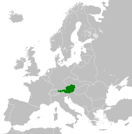
| цяперашняя | 00:38, 13 жніўня 2013 | | 450 × 456 (473 кб) | TRAJAN 117 (Абмеркаваньне | унёсак) | {{Information |Description ={{en|1=The Federal State of Austria in 1938.}} |Source ={{own}} {{AttribSVG|Blank map of Europe 1929-1938.svg|Alphathon}} |Author =TRAJAN 117 {{created with Inkscape}} |Date =... |
Вы ня можаце перазапісаць гэты файл.
Выкарыстаньне файла
Больш чым 100 старонак выкарыстоўваюць гэты файл. У гэтым сьпісе толькі 100 старонак, якія выкарыстоўваюць гэты файл. Даступны таксама поўны сьпіс.
.svg)
- User:Alphathon/Historical Europe
- File:Albania 1956-1990.svg
- File:Albanian Kingdom (1935).svg
- File:Albanian Kingdom (1939).svg
- File:Austrian Lombardy 1789.svg
- File:Austrian Netherlands 1789.svg
- File:Austro-Hungarian Monarchy (1914).svg
- File:Blank map of Europe 1812.svg
- File:Blank map of Europe 1890.svg
- File:Blank map of Europe 1914.svg
- File:Blank map of Europe 1929-1938.svg
- File:Blank map of Europe 1956-1990.svg
- File:Blank map of Europe October 1938 - March 1939.svg
- File:Bulgaria 1956-1990.svg
- File:Confederation of the Rhine (1812).svg
- File:Cortina di ferro.png
- File:Czechoslovak Republic (1938).svg
- File:Czechoslovak Republic (1939).svg
- File:Czechoslovakia 1956–1990.svg
- File:Duchy of Holstein 1789.svg
- File:Duchy of Mecklenburg-Schwerin 1789.svg
- File:Duchy of Warsaw (1812).svg
- File:Duchy of Württemberg 1789.svg
- File:East Germany 1956-1990.svg
- File:Ecclesiastical lands of the Holy Roman Empire 1789.svg
- File:Electorate of Bavaria 1789.svg
- File:Electorate of Brunswick-Lüneburg 1789.svg
- File:Electorate of Saxony 1789.svg
- File:Europe 1789.svg
- File:Europe 1942.svg
- File:First French Empire 1812.svg
- File:Free City Danzig 1930.svg
- File:Free City of Danzig (1812).svg
- File:French Empire (1812).svg
- File:French State (1942).svg
- File:General Government (1942).svg
- File:German Empire 1914.svg
- File:German Reich (1939).svg
- File:Grand Duchy of Tuscany 1789.svg
- File:Grand Principality of Finland (1914).svg
- File:Greater German Reich (1942).svg
- File:Habsburg Monarchy 1789.svg
- File:Hellenic Republic (1935).svg
- File:Hungary 1956-1990.svg
- File:Imperial Italy.png
- File:InterwarCentralEurope.png
- File:Kingdom of Bulgaria (1914).svg
- File:Kingdom of Bulgaria (1942).svg
- File:Kingdom of France (1789).svg
- File:Kingdom of Greece (1890).svg
- File:Kingdom of Greece (1914).svg
- File:Kingdom of Greece (1973).svg
- File:Kingdom of Hungary (1942).svg
- File:Kingdom of Italy (1936).svg
- File:Kingdom of Italy (Napoleonic).svg
- File:Kingdom of Montenegro (1914).svg
- File:Kingdom of Portugal (1890).svg
- File:Kingdom of Prussia 1789.svg
- File:Kingdom of Romania (1890).svg
- File:Kingdom of Romania (1914).svg
- File:Kingdom of Romania (1939).svg
- File:Kingdom of Sardinia 1789.svg
- File:Kingdom of Serbia (1890).svg
- File:Kingdom of Serbia (1914).svg
- File:Kingdom of Spain (1789).svg
- File:Landgraviate of Hesse-Kassel 1789.svg
- File:Location Moldavian Democratic Republic.png
- File:Map Holy Roman Empire 1789.svg
- File:Map of the Republic of Serbia (2006–2008).svg
- File:Maps of Yugoslavia and FR Yugoslavia.svg
- File:Military Administration in Belgium and Northern France (1942).svg
- File:Military Administration in France (1942).svg
- File:Papal States 1789.svg
- File:Poland 1930.svg
- File:Poland 1956-1990.svg
- File:Polish-Lithuanian Commonwealth 1789.svg
- File:Prince-Bishopric of Montenegro (1812).svg
- File:Principality of Albania (1914).svg
- File:Principality of Bulgaria (1890).svg
- File:Principality of Montenegro (1890).svg
- File:Protectorate of Bohemia and Moravia (1942).svg
- File:Reichskommissariat Niederlande (1942).svg
- File:Reichskommissariat Norwegen (1942).svg
- File:Reichskommissariat Ostland (1942).svg
- File:Reichskommissariat Ukraine (1942).svg
- File:Republic of Genoa 1789.svg
- File:Republic of Montenegro (2006).svg
- File:Republic of Venice 1789.svg
- File:Republic of the Seven United Netherlands (1789).svg
- File:Romania 1956-1990.svg
- File:Serbia 1942.svg
- File:Slovak Republic (1942).svg
- File:Spanish Republic (1936).svg
- File:Spanish State (1975).svg
- File:Sweden 1789.svg
- File:Territory of the Serbian Uprising (1812).svg
- File:Voivodeship of Moldavia (1812).svg
- File:Voivodeship of Wallachia (1812).svg
- File:Weimar Republic 1930.svg
- File:West Germany 1956-1990.svg
.svg)
.svg)
.svg)
.svg)
Паказаць болей спасылак на гэты файл.
Глябальнае выкарыстаньне файла
Гэты файл выкарыстоўваецца ў наступных вікі:
- Выкарыстаньне ў ar.wikipedia.org
- Выкарыстаньне ў ba.wikipedia.org
- Выкарыстаньне ў be-tarask.wikipedia.org
- Выкарыстаньне ў be.wikipedia.org
- Выкарыстаньне ў ca.wikipedia.org
- Выкарыстаньне ў cs.wikipedia.org
- Выкарыстаньне ў da.wikipedia.org
- Выкарыстаньне ў el.wikipedia.org
- Выкарыстаньне ў en.wikipedia.org
- Выкарыстаньне ў eo.wikipedia.org
- Выкарыстаньне ў es.wikipedia.org
- Выкарыстаньне ў et.wikipedia.org
- Выкарыстаньне ў fa.wikipedia.org
- Выкарыстаньне ў fi.wikipedia.org
- Выкарыстаньне ў fr.wikipedia.org
- Выкарыстаньне ў he.wikipedia.org
- Выкарыстаньне ў hr.wikipedia.org
- Выкарыстаньне ў hy.wikipedia.org
- Выкарыстаньне ў id.wikipedia.org
- Выкарыстаньне ў it.wikipedia.org
- Выкарыстаньне ў ja.wikipedia.org
- Выкарыстаньне ў ka.wikipedia.org
- Выкарыстаньне ў ko.wikipedia.org
- Выкарыстаньне ў lt.wikipedia.org
- Выкарыстаньне ў mk.wikipedia.org
- Выкарыстаньне ў ms.wikipedia.org
- Выкарыстаньне ў nl.wikipedia.org
- Выкарыстаньне ў pl.wikipedia.org
- Выкарыстаньне ў pt.wikipedia.org
Паказаць глябальнае выкарыстаньне гэтага файла.
.svg)
.svg&oldid=754000440)