File:Feldbahn Baranowitschi - Grabowez - Wel Łuki - Sawin - Pod Sokolje - Myschankabrücke - Kriwoschin - Lesnaja.jpg
Jump to navigation
Jump to search
Size of this preview: 248 × 598 pixels. Other resolutions: 99 × 240 pixels | 576 × 1,389 pixels.
Original file (576 × 1,389 pixels, file size: 523 KB, MIME type: image/jpeg)
Captions
Captions
Add a one-line explanation of what this file represents
Summary
[edit]
| Description |
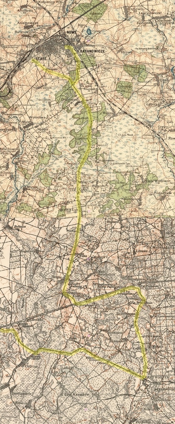
Deutsch: Feldbahn Baranowitschi - Grabowez - Wel Łuki - Sawin - Pod Sokolje - Myschankabrücke - Kriwoschin - Lesnaja |
| Date | between circa 1924 and circa 1927 |
| Source |
Topographic map of Western Belarus, ca. 1924-1927 ,_Tafel.jpg) |
| Author | Unknown author |
| Other versions |
| This is a retouched picture, which means that it has been digitally altered from its original version. Modifications: Retouched using MS Paint for stitching several maps and GIMP 2.10 to highlight the narrow gauge railway. Modifications made by NearEMPTiness.
|
Licensing
[edit]
|
This work is in the public domain in its country of origin and other countries and areas where the copyright term is the author's life plus 70 years or fewer. This work is in the public domain in the United States because it was published (or registered with the U.S. Copyright Office) before January 1, 1929. | |
| This file has been identified as being free of known restrictions under copyright law, including all related and neighboring rights. | |
File history
Click on a date/time to view the file as it appeared at that time.
| Date/Time | Thumbnail | Dimensions | User | Comment | |
|---|---|---|---|---|---|
| current | 12:18, 9 May 2023 | 576 × 1,389 (523 KB) | NearEMPTiness (talk | contribs) | Cropped 1 % horizontally using CropTool with lossless mode. | |
| 12:10, 9 May 2023 |  | 582 × 1,389 (561 KB) | NearEMPTiness (talk | contribs) | + Industriegleis zum Bahnhof | |
| 09:28, 8 May 2023 | 572 × 1,388 (560 KB) | NearEMPTiness (talk | contribs) | Route of narrow gauge railway highlighted | ||
| 09:26, 8 May 2023 |  | 1,198 × 2,860 (2.15 MB) | NearEMPTiness (talk | contribs) | Uploaded a work by {{unknown}} from [http://www.oldmap.org/map-belarus_zapad/?x=26.143685&y=52.864347 Topographic map of Western Belarus, ca. 1924-1927] with UploadWizard |
You cannot overwrite this file.
File usage on Commons
There are no pages that use this file.
File usage on other wikis
The following other wikis use this file:
- Usage on be-tarask.wikipedia.org
- Usage on de.wikipedia.org