File:Fertile Crescent map.png
Zur Navigation springen
Zur Suche springen

Grondezza da questa prevista: 488 × 600 pixels. Other resoluziuns: 195 × 240 pixels | 391 × 480 pixels | 625 × 768 pixels | 833 × 1.024 pixels | 1.988 × 2.443 pixels.
Datoteca originala (1.988 × 2.443 pixels, grondezza da datoteca: 717 KB, tip da MIME: image/png)
Bildtexte
Kurzbeschreibungen
Ergänze eine einzeilige Erklärung, was diese Datei darstellt.
The first signs of monogamy
{{subst:proposed deletion|concern=Incorrect details as well as political motivated terms. See discussion please remove image}}

|
File:Map of fertile crescent.svg ist eine vektorisierte Version dieses Bildes. Diese sollte an Stelle des Rasterbildes verwendet werden, sofern sie nicht schlechter ist.
File:Fertile Crescent map.png → File:Map of fertile crescent.svg
Für weitere Informationen siehe Help:SVG. |
 |
Resumaziun
[modifitgar]| Descripziun |
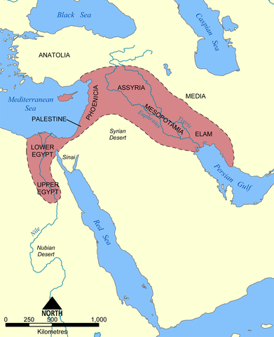
English: This map shows the location and extent of the Fertile Crescent, a region in the Middle East incorporating Ancient Egypt; the Levant; and Mesopotamia.
Français : Carte en anglais du Croissant fertile, région du Moyen-Orient incluant l'Égypte antique, le Levant et la Mésopotamie où a débuté la civilisation. |
| Data | |
| Funtauna |
Eigenes Werk This image was based on a similar map from the 1994 edition of the Encyclopedia Britannica. |
| Autur | User:NormanEinstein |
| Andere Versionen |
[]
See also:
|


Licenza
[modifitgar]
Ich, der Urheberrechtsinhaber dieses Werkes, veröffentliche es hiermit unter der folgenden Lizenz:

|
Es ist erlaubt, die Datei unter den Bedingungen der GNU-Lizenz für freie Dokumentation, Version 1.2 oder einer späteren Version, veröffentlicht von der Free Software Foundation, zu kopieren, zu verbreiten und/oder zu modifizieren; es gibt keine unveränderlichen Abschnitte, keinen vorderen und keinen hinteren Umschlagtext.
Der vollständige Text der Lizenz ist im Kapitel GNU-Lizenz für freie Dokumentation verfügbar. |
| Diese Datei ist unter der Creative-Commons-Lizenz „Namensnennung – Weitergabe unter gleichen Bedingungen 3.0 nicht portiert“ lizenziert. | ||
| ||
| Diese Lizenzmarkierung wurde auf Grund der GFDL-Lizenzaktualisierung hinzugefügt. |
Du darfst es unter einer der obigen Lizenzen deiner Wahl verwenden.
derivative works
[modifitgar]
Derivative works of this file:
Istorgia da las versiuns
Clicca sin ina data/temps per vesair la versiun da lura.
| data/temp | Maletg da prevista | dimensiuns | Utilisader | commentari | |
|---|---|---|---|---|---|
| actual | 18:28, 17. zercl 2010 | | 1.988 × 2.443 (717 KB) | Ras67 (Discussiun | contribuziuns) | cropped and squeezed |
| 20:30, 21. dec 2005 |  | 2.000 × 2.454 (990 KB) | NormanEinstein (Discussiun | contribuziuns) | This map shows the location and extent of the '''Fertile Crescent''', a region in the Middle East incorporating Ancient Egypt, the Levant, and Mesopotamia where civilisation started. Created by NormanEinstein, December 21, 2005. {{GFDL-self}} [[Categor |
Ti na pos betg sursvriver questa datoteca.
Utilisaziun da la datoteca
Las suandantas 26 paginas èn colliadas cun questa datoteca:
- Atlas of Egypt
- Atlas of Iran
- Atlas of Iraq
- Atlas of Israel
- Atlas of Lebanon
- Atlas of Palestine
- Atlas of Syria
- Maps of the history of the Levant
- File:Croissant fertile carte.png
- File:Fertile Crescent map.png
- File:Fertile Crescent map He.png
- File:Fertile Crescent map it.PNG
- File:Fertile Crescent map rus.png
- File:Fruchtbarer Halbmond map deutsch.png
- File:Ilgora Emankorraren mapa.png
- File:Map of fertile crescent-af.svg
- File:Map of fertile crescent-ar.svg
- File:Map of fertile crescent-ca.svg
- File:Map of fertile crescent-ru.svg
- File:Map of fertile crescent.svg
- File:Map of fertile cresent-sr.svg
- File:Mapa da crescente fértil.png
- File:Mapa del Creciente Fértil.png
- File:Mapa do Crecente Fertil en galego.png
- File:Vruchtbare sikkel.svg
- Template:Other versions/Fertile Crescent map
Diever da datoteca global
Die nachfolgenden anderen Wikis verwenden diese Datei:
- Utilisaziun sin azb.wikipedia.org
- Utilisaziun sin az.wikipedia.org
- Utilisaziun sin bg.wikipedia.org
- Utilisaziun sin bn.wikipedia.org
- Utilisaziun sin cs.wikipedia.org
- Utilisaziun sin en.wikipedia.org
- Utilisaziun sin en.wikiversity.org
- Utilisaziun sin en.wiktionary.org
- Utilisaziun sin et.wikipedia.org
- Utilisaziun sin fa.wikipedia.org
- Utilisaziun sin fi.wikipedia.org
- Utilisaziun sin fr.wikipedia.org
- Utilisaziun sin gl.wikipedia.org
- Utilisaziun sin he.wikipedia.org
- Utilisaziun sin hu.wikipedia.org
- Utilisaziun sin id.wikipedia.org
- Utilisaziun sin it.wikipedia.org
- Utilisaziun sin ko.wikipedia.org
- Utilisaziun sin lv.wikipedia.org
- Utilisaziun sin mk.wikipedia.org
- Utilisaziun sin mwl.wikipedia.org
- Utilisaziun sin nn.wikipedia.org
- Utilisaziun sin no.wikipedia.org
- Utilisaziun sin pl.wikipedia.org
- Utilisaziun sin pl.wiktionary.org
- Utilisaziun sin pt.wikibooks.org
- Utilisaziun sin ro.wikipedia.org
- Utilisaziun sin sh.wikipedia.org
- Utilisaziun sin simple.wikipedia.org
- Utilisaziun sin sk.wikipedia.org
- Utilisaziun sin sq.wikipedia.org
- Utilisaziun sin sv.wikipedia.org
Weitere globale Verwendungen dieser Datei anschauen.