File:Finedon Elevation Map.png
Jump to navigation
Jump to search

Size of this preview: 436 × 600 pixels. Other resolutions: 174 × 240 pixels | 349 × 480 pixels | 558 × 768 pixels | 744 × 1,024 pixels | 1,803 × 2,480 pixels.
Original file (1,803 × 2,480 pixels, file size: 1.48 MB, MIME type: image/png)
Captions
Captions
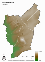
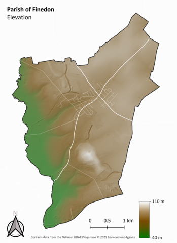
An elevation map of the Parish of Finedon.
Summary
[edit]
| Description |
English: An elevation map of the Parish of Finedon with the road network displayed for reference. |
| Date | |
| Source | Own work using data licensed under the Open Government Licence v3.0 (OGL v.3) |
| Author | Christopher French |
Licensing
[edit]
_(St_Edwards_Crown).svg)
|
This file is licensed under the United Kingdom Open Government Licence v3.0. |
See also: Meta for information on usage on Wikimedia wikis.
|
File history
Click on a date/time to view the file as it appeared at that time.
| Date/Time | Thumbnail | Dimensions | User | Comment | |
|---|---|---|---|---|---|
| current | 10:26, 7 June 2021 | | 1,803 × 2,480 (1.48 MB) | Chrisengland (talk | contribs) | Uploaded a work by Christopher French from Own work using data licensed under the Open Government Licence v3.0 (OGL v.3) with UploadWizard |
You cannot overwrite this file.
File usage on Commons
There are no pages that use this file.
File usage on other wikis
The following other wikis use this file:
- Usage on en.wikipedia.org