File:Fire Control Tower 23.JPG
Jump to navigation
Jump to search

Size of this preview: 450 × 600 pixels. Other resolutions: 180 × 240 pixels | 360 × 480 pixels | 576 × 768 pixels | 768 × 1,024 pixels | 1,536 × 2,048 pixels | 2,700 × 3,600 pixels.
Original file (2,700 × 3,600 pixels, file size: 2.9 MB, MIME type: image/jpeg)
Captions
Captions
Add a one-line explanation of what this file represents
Summary
[edit]
| Description |
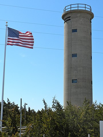
English: Fire Control Tower No. 23 on NRHP since November 17, 2003. On Sunset Boulevard near Sunset Beach west of West Cape May (village) near Cape May Point. Tower was used during WWII, together with batteries in Lewes, Delaware to control the entrance to Delaware Bay. See also File:Battery 223 Cape May Point.JPG. In Lower Township, Cape May County, NJ
|
||
| Date | |||
| Source | Own work | ||
| Author | Smallbones |
| Camera location | | View this and other nearby images on: OpenStreetMap |
|---|
Licensing
[edit]
| I, the copyright holder of this work, release this work into the public domain. This applies worldwide. In some countries this may not be legally possible; if so: I grant anyone the right to use this work for any purpose, without any conditions, unless such conditions are required by law. |
File history
Click on a date/time to view the file as it appeared at that time.
| Date/Time | Thumbnail | Dimensions | User | Comment | |
|---|---|---|---|---|---|
| current | 14:02, 6 April 2010 | | 2,700 × 3,600 (2.9 MB) | Smallbones (talk | contribs) | {{Information |Description={{en|1=Fire Control Tower No. 23 on NRHP since November 17, 2003. On Sunset Boulevard near Sunset Beach west of West Cape May (village) near Cape May Point. Tower was used during WWII, together with batteries in Lewes, Delaware |
You cannot overwrite this file.
File usage on Commons
The following page uses this file:
File usage on other wikis
The following other wikis use this file:
- Usage on en.wikipedia.org
- Usage on www.wikidata.org