File:Flevoland position.svg
ナビゲーションに移動
検索に移動

この SVG ファイルのこの PNG プレビューのサイズ: 200 × 236 ピクセル. その他の解像度: 203 × 240 ピクセル | 407 × 480 ピクセル | 651 × 768 ピクセル | 868 × 1,024 ピクセル | 1,736 × 2,048 ピクセル。
元のファイル (SVG ファイル、200 × 236 ピクセル、ファイルサイズ: 157キロバイト)
キャプション
キャプション
このファイルの内容を1行で記述してください
概要[編集]
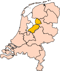
| 解説 | Location of the province of Flevoland in the Netherlands. |
| 日付 | |
| 原典 | Own work, based on freely available GIS data |
| 作者 | User:Mtcv |
| 許可 (ファイルの再利用) |
Data: attribution required; my work: PD |
| その他のバージョン | I attempted to make an svg version of Image:Flevoland-Position.png (with less simplified boundaries) |
Clickable version[編集]

ライセンス[編集]

|
このファイルの著作権者Centraal Bureau voor de Statistiekは、あらゆる人があらゆる目的でこのファイルを使用することを許可しています。ただし著作権者の名義が適切に表示されることを条件とします。再頒布、二次的著作物の製作、商用利用等のあらゆる使用が許可されています。 |
|
|
| 注釈 | この画像には注釈がついています: コモンズで注釈を見る |


ファイルの履歴
過去の版のファイルを表示するには、その版の日時をクリックしてください。
| 日付と時刻 | サムネイル | 寸法 | 利用者 | コメント | |
|---|---|---|---|---|---|
| 現在の版 | 2019年3月2日 (土) 17:19 | | 200 × 236 (157キロバイト) | Thayts (トーク | 投稿記録) | update |
| 2006年10月3日 (火) 00:44 |  | 200 × 236 (158キロバイト) | Mtcv (トーク | 投稿記録) | {{Information| |Description=Location of the province of Noord-Holland (North Holland) in the Netherlands. |Source=Own work, based on freely available GIS data |Date=2006-10-03 |Author=User:Mtcv |Permission=Data: attribution required; my work: PD |othe |
このファイルは上書きできません。
ファイルの使用状況
以下の 14 ページがこのファイルを使用しています:
- Maps of the Netherlands
- File:Drenthe position.svg
- File:Flevoland position.svg
- File:Friesland position.svg
- File:Gelderland position.svg
- File:Groningen position.svg
- File:Limburg position.svg
- File:Noord-Brabant position.svg
- File:Noord-Holland position.svg
- File:Overijssel position.svg
- File:Provinces of the Netherlands.svg
- File:Utrecht position.svg
- File:Zeeland position.svg
- File:Zuid-Holland position.svg
グローバルなファイル使用状況
以下に挙げる他のウィキがこの画像を使っています:
- ar.wikipedia.org での使用状況
- be-tarask.wikipedia.org での使用状況
- br.wikipedia.org での使用状況
- en.wikipedia.org での使用状況
- eu.wikipedia.org での使用状況
- fi.wikipedia.org での使用状況
- hi.wikipedia.org での使用状況
- hu.wikipedia.org での使用状況
- id.wikipedia.org での使用状況
- ja.wikipedia.org での使用状況
- jv.wikipedia.org での使用状況
- lb.wikipedia.org での使用状況
- nds-nl.wikipedia.org での使用状況
- nn.wikipedia.org での使用状況
- pt.wikipedia.org での使用状況
- ru.wikipedia.org での使用状況
このファイルのグローバル使用状況を表示する。