File:Flightlog - Luftbild Steyr 4 III.jpg
Jump to navigation
Jump to search

Size of this preview: 800 × 486 pixels. Other resolutions: 320 × 194 pixels | 640 × 389 pixels | 1,024 × 622 pixels | 1,280 × 777 pixels | 2,886 × 1,752 pixels.
Original file (2,886 × 1,752 pixels, file size: 1.69 MB, MIME type: image/jpeg)
Captions
Captions
Add a one-line explanation of what this file represents
Summary[edit]
| Description |
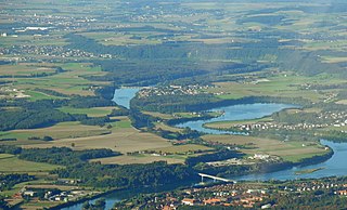
Deutsch: Die Enns an der Landesgrenze von Ober- und Niederösterreich mit dem Rückstau des Kraftwerks Staning. Am linken Ufer liegt die Ortslage Winkling, gehörig zu Dietach, Kronstorf und Steyr |
| Date | |
| Source | File:Flightlog - Luftbild Steyr 4.jpg |
| Author |
Photograph: flightlog Bearbeitung (Ausschnitt erstellt, Farbe und Kontrast korrigiert): Christoph Waghubinger (Lewenstein) |
Licensing[edit]
This file is licensed under the Creative Commons Attribution 2.0 Generic license.
- You are free:
- to share – to copy, distribute and transmit the work
- to remix – to adapt the work
- Under the following conditions:
- attribution – You must give appropriate credit, provide a link to the license, and indicate if changes were made. You may do so in any reasonable manner, but not in any way that suggests the licensor endorses you or your use.
File history
Click on a date/time to view the file as it appeared at that time.
| Date/Time | Thumbnail | Dimensions | User | Comment | |
|---|---|---|---|---|---|
| current | 13:32, 24 July 2019 | | 2,886 × 1,752 (1.69 MB) | Lewenstein (talk | contribs) | == {{int:filedesc}} == {{Information |Description ={{de|1=Die Enns an der Landesgrenze von Ober- und Niederösterreich mit dem Rückstau des Kraftwerks Staning. Am linken Ufer liegt die Ortslage {{wd|Winkling (Gemeinden Dietach, Kronstorf, Steyr)|Winkling}}, gehörig zu Dietach, Kronstorf und Steyr}} |Source =File:Flightlog - Luftbild Steyr 4.jpg |Author ={{photo}}: [https://www.flickr.com/people/flightlog/ flightlog]<br>Bearbeitung (Ausschnitt erstellt, Farbe und Kontras... |
You cannot overwrite this file.
File usage on Commons
The following 3 pages use this file:
File usage on other wikis
The following other wikis use this file:
- Usage on de.wikipedia.org
- Usage on www.wikidata.org