File:Flooding near the Betsiboka River, Madagascar 2010-03-23 lrg.jpg
Aller à la navigation
Aller à la recherche
Taille de cet aperçu : 600 × 600 pixels. Autres résolutions : 240 × 240 pixels | 480 × 480 pixels | 768 × 768 pixels | 1 024 × 1 024 pixels | 2 048 × 2 048 pixels | 3 000 × 3 000 pixels.
Fichier d’origine (3 000 × 3 000 pixels, taille du fichier : 5,34 Mio, type MIME : image/jpeg)
Légendes
Légendes
Ajoutez en une ligne la description de ce que représente ce fichier
Description
[modifier]| Description |
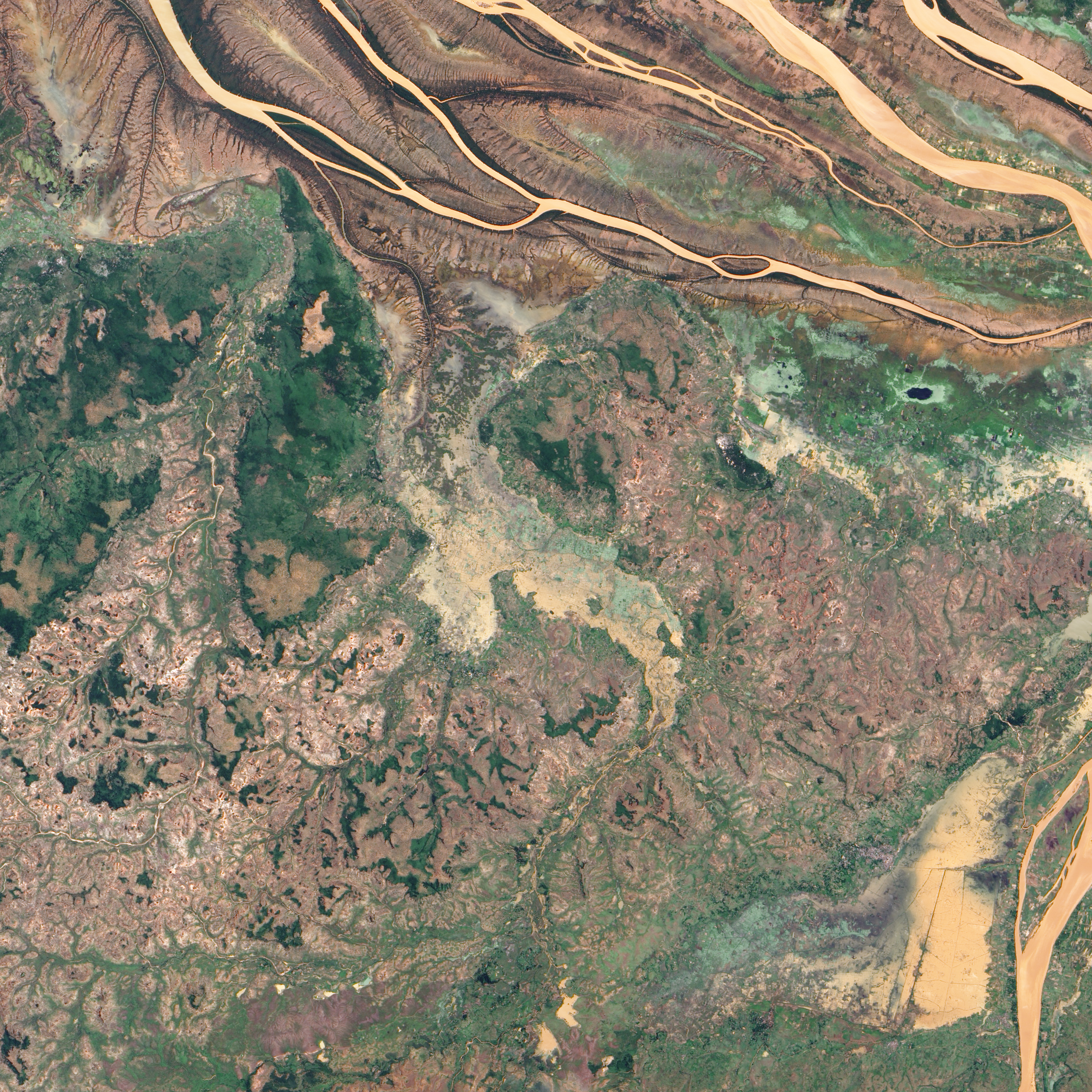
English: In northwestern Madagascar, the Betsiboka River flows toward the coast, its braided streams emptying into the Bombetoka Bay. In late March 2010, however, not long after Tropical Cyclone Hubert passed through the region, part of the river pushed over its banks, flooding nearby agricultural fields.
The Advanced Land Imager (ALI) on NASA’s Earth Observing-1 (EO-1) satellite captured this natural-color image on March 23, 2010. Immediately south of the Betsiboka River, which is visible in the large image, this area is roughly 40 kilometers (25 miles) from the coast. The wide beige-and-green swath filling most of the image is flooded, and uneven rectangles demarcate individual fields. Only areas of relatively high ground appear to have escaped standing water. |
| Date | |
| Source | http://earthobservatory.nasa.gov/NaturalHazards/view.php?id=43240&src=nha |
| Auteur | NASA |
| Autres versions |
|

Conditions d’utilisation
[modifier]
| Ce fichier provient de la NASA. Sauf exception, les documents créés par la NASA ne sont pas soumis à copyright. Pour plus d'informations, voir la politique de copyright de la NASA. | ||
 |
Attention :
|
Historique du fichier
Cliquer sur une date et heure pour voir le fichier tel qu'il était à ce moment-là.
| Date et heure | Vignette | Dimensions | Utilisateur | Commentaire | |
|---|---|---|---|---|---|
| actuel | 26 janvier 2013 à 00:53 | | 3 000 × 3 000 (5,34 Mio) | Slick-o-bot (d | contributions) | Bot: convert to a non-interlaced jpeg (see bug #17645) |
| 26 mars 2010 à 00:50 |  | 3 000 × 3 000 (5,04 Mio) | Captain-tucker (d | contributions) | {{Information |Description={{en|In northwestern Madagascar, the Betsiboka River flows toward the coast, its braided streams emptying into the Bombetoka Bay. In late March 2010, however, not long after Tropical Cyclone Hubert passed through the region, par |
Vous ne pouvez pas remplacer ce fichier.
Utilisations locales du fichier
La page suivante utilise ce fichier :
Utilisations du fichier sur d’autres wikis
Les autres wikis suivants utilisent ce fichier :
- Utilisation sur en.wikipedia.org
- Utilisation sur fr.wikipedia.org
- Utilisation sur ha.wikipedia.org