File:Fontaine de la Force FR Hans Gieng 05 cropped.jpg
Jump to navigation
Jump to search

Size of this preview: 458 × 600 pixels. Other resolutions: 183 × 240 pixels | 366 × 480 pixels | 586 × 768 pixels | 1,055 × 1,382 pixels.
Original file (1,055 × 1,382 pixels, file size: 1.76 MB, MIME type: image/jpeg)
Captions
Captions
Add a one-line explanation of what this file represents
Summary[edit]
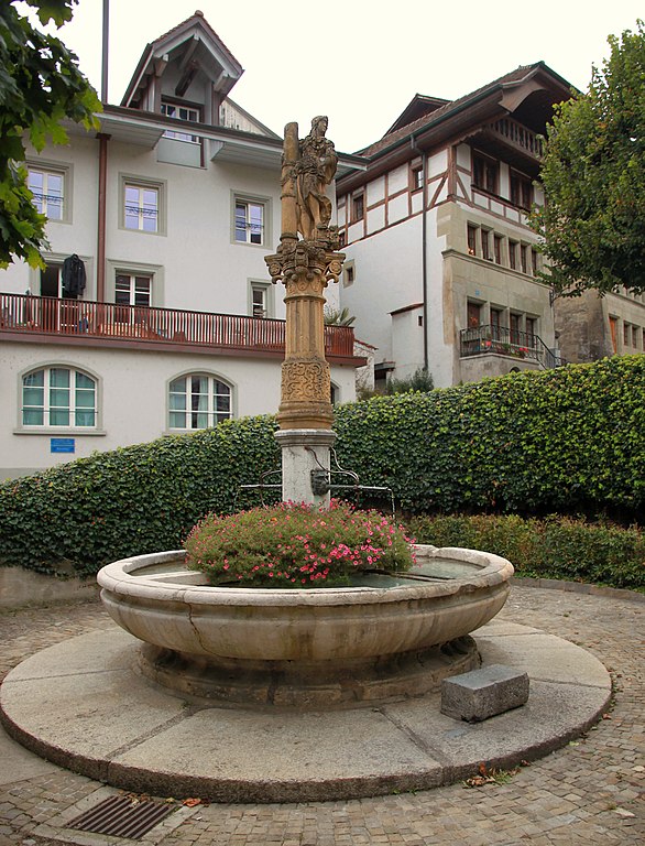
| Fountain of the Strength at the Escalier du Court-Chemin in Fribourg | ||||||||||||||||||||
|---|---|---|---|---|---|---|---|---|---|---|---|---|---|---|---|---|---|---|---|---|
| Artist |
|
|||||||||||||||||||
| Photographer | ||||||||||||||||||||
| Title |
Fountain of the Strength at the Escalier du Court-Chemin in Fribourg |
|||||||||||||||||||
| Description |
Strength is represented as fortitudo, one of the cardinal virtues. She wears armor and helmet, embraces a damaged column with her right arm and has placed her left foot on the chipped capital. The statue, created in the studio of Hans Gieng, amazes with its plastic qualities and expressiveness. Gieng designed this figure after a woodcut by Hans Burgkmair. |
|||||||||||||||||||
| Date | 1549―1550 (sculpture} | |||||||||||||||||||
| Dimensions |
height oft the statue 138 cm (54.3 in) |
|||||||||||||||||||
| Object history | In 1963-1964, the entire Strenght fountain was overhauled. In the process, the fountain figure and the column shaft were transferred to the Fribourg Museum of Art and History. Théo Aeby created a copy of the statue and the column. This copy has since been on display at its original location on Escaliers du Court-Chemin in the lower town of Fribourg. | |||||||||||||||||||
| Credit line |
|
|||||||||||||||||||
| Notes | The sculpture shown is a copy; the original is in the Museum of Art and History Fribourg, Switzerland, nr. MAHF 1964-005a | |||||||||||||||||||
| References |
|
|||||||||||||||||||
| Source | Martin Thurnherr | |||||||||||||||||||
| Permission (Reusing this file) |
|
|||||||||||||||||||
| Other versions | ||||||||||||||||||||


Licensing[edit]
I, the copyright holder of this work, hereby publish it under the following license:
This file is licensed under the Creative Commons Attribution-Share Alike 4.0 International license.
Attribution: Martin Thurnherr
- You are free:
- to share – to copy, distribute and transmit the work
- to remix – to adapt the work
- Under the following conditions:
- attribution – You must give appropriate credit, provide a link to the license, and indicate if changes were made. You may do so in any reasonable manner, but not in any way that suggests the licensor endorses you or your use.
- share alike – If you remix, transform, or build upon the material, you must distribute your contributions under the same or compatible license as the original.
| Object location | | View this and other nearby images on: OpenStreetMap |
|---|
File history
Click on a date/time to view the file as it appeared at that time.
| Date/Time | Thumbnail | Dimensions | User | Comment | |
|---|---|---|---|---|---|
| current | 23:13, 22 October 2021 | | 1,055 × 1,382 (1.76 MB) | AxelHH (talk | contribs) | {{Information |Description= |Source={{own}} |Date= |Author= AxelHH |Permission= |other_versions= }} |
You cannot overwrite this file.
File usage on Commons
The following page uses this file:
File usage on other wikis
The following other wikis use this file:
- Usage on de.wikipedia.org