File:Formative Era sites.svg
跳至導覽
跳至搜尋

此 SVG 檔案的 PNG 預覽的大小:629 × 459 像素。 其他解析度:320 × 234 像素 | 640 × 467 像素 | 1,024 × 747 像素 | 1,280 × 934 像素 | 2,560 × 1,868 像素。
原始檔案 (SVG 檔案,表面大小:629 × 459 像素,檔案大小:100 KB)
說明
說明
添加單行說明來描述出檔案所代表的內容
摘要[編輯]

|
This SVG file contains embedded text that can be translated into your language, using any capable SVG editor, text editor or the SVG Translate tool. For more information see: About translating SVG files. |
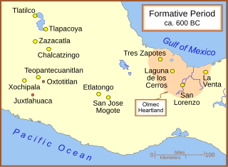
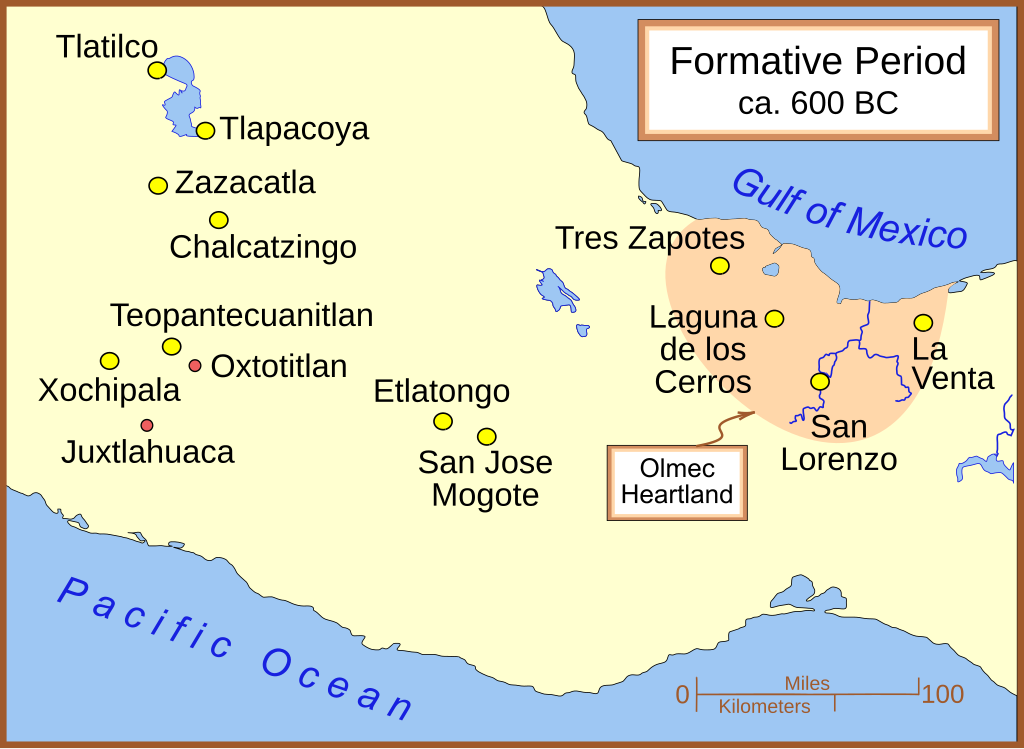
A map of the better known Mexican sites from the Formative Era, with a very general date of 600 BC (BCE). The yellow sites are known villages and towns. The smaller red dots mark locations where artifacts or art has been found without evidence of habitation.
Other versions[編輯]
Part of a series:
-
 }Formative Period sites in Central Mexico
 -
 Formative Period sites in Southeastern Mesoamerica
 -
 Map of the Olmec Heartland
 -
 Classic era sites in Central Mexico
 -
 Site with early evidence for ballplaying
 -
 Maya sites in northern Yucatan 800 AD


Other versions[編輯]
授權條款[編輯]
我,本作品的著作權持有者,決定用以下授權條款發佈本作品:

|
已授權您依據自由軟體基金會發行的無固定段落、封面文字和封底文字GNU自由文件授權條款1.2版或任意後續版本,對本檔進行複製、傳播和/或修改。該協議的副本列在GNU自由文件授權條款中。 |
| 此檔案採用共享創意 姓名標示-相同方式分享 3.0 未在地化版本授權條款。 | ||
| ||
| 已新增授權條款標題至此檔案,作為GFDL授權更新的一部份。 |
您可以選擇您需要的授權條款。
檔案歷史
點選日期/時間以檢視該時間的檔案版本。
| 日期/時間 | 縮圖 | 尺寸 | 用戶 | 備註 | |
|---|---|---|---|---|---|
| 目前 | 2009年1月29日 (四) 14:22 | | 629 × 459(100 KB) | Madman2001(對話 | 貢獻) | Added Xochipala |
| 2007年3月18日 (日) 04:01 |  | 613 × 459(98 KB) | Madman2001(對話 | 貢獻) | a couple of fixes | |
| 2007年2月25日 (日) 05:41 |  | 613 × 459(98 KB) | Madman2001(對話 | 貢獻) | some modifications to match image:Olmec Heartland Overview v2.sg | |
| 2007年2月24日 (六) 21:09 |  | 613 × 459(97 KB) | Madman2001(對話 | 貢獻) | minor modifications | |
| 2007年2月22日 (四) 21:48 |  | 613 × 459(97 KB) | Madman2001(對話 | 貢獻) | Added another site & adjusted colours | |
| 2007年2月22日 (四) 03:36 |  | 613 × 459(96 KB) | Madman2001(對話 | 貢獻) | A few small fixes | |
| 2007年2月22日 (四) 03:33 |  | 607 × 456(59 KB) | Madman2001(對話 | 貢獻) | A map of the better known Mexican sites from the Formative Era. |
無法覆蓋此檔案。
檔案用途
下列12個頁面有用到此檔案:
- Atlas of Mexico
- File:Classic sites 1.svg
- File:Early Mesoamerican Ballgame sites 1.svg
- File:Formative Era sites.svg
- File:Formative Era sites ru.svg
- File:Maya site northern Yucatan 800 AD-es.svg
- File:Maya site northern Yucatan 800 AD.svg
- File:Olmec Heartland Overview 4.svg
- File:Olmec Heartland Overview v2.svg
- File:SE Mesoamerican Formative Period sites.svg
- Category:San José Mogote
- Category:Teopantecuanitlán
全域檔案使用狀況
以下其他 wiki 使用了這個檔案:
- be.wikipedia.org 的使用狀況
- bg.wikipedia.org 的使用狀況
- de.wikipedia.org 的使用狀況
- en.wikipedia.org 的使用狀況
- Olmecs
- Mesoamerican chronology
- Teopantecuanitlan
- Chalcatzingo
- San José Mogote
- Zazacatla
- Olmec influences on Mesoamerican cultures
- Juxtlahuaca
- Oxtotitlán
- Xochipala
- Mirrors in Mesoamerican culture
- Regional communications in ancient Mesoamerica
- User:Abyssal/Prehistory of North America/DYK/46
- User:Abyssal/Portal Prehistory of North America
- en.wikibooks.org 的使用狀況
- es.wikipedia.org 的使用狀況
- fa.wikipedia.org 的使用狀況
- fi.wikipedia.org 的使用狀況
- fr.wikipedia.org 的使用狀況
- gl.wikipedia.org 的使用狀況
- hy.wikipedia.org 的使用狀況
- it.wikipedia.org 的使用狀況
- ja.wikipedia.org 的使用狀況
- ka.wikipedia.org 的使用狀況
- lt.wikipedia.org 的使用狀況
- pl.wikipedia.org 的使用狀況
檢視此檔案的更多全域使用狀況。