File:Former Luther T. Ward Junior High School, Kingsland Avenue, University City, MO - 53268210889.jpg
Jump to navigation
Jump to search

Size of this preview: 450 × 600 pixels. Other resolutions: 180 × 240 pixels | 360 × 480 pixels | 576 × 768 pixels | 768 × 1,024 pixels | 1,536 × 2,048 pixels | 3,024 × 4,032 pixels.
Original file (3,024 × 4,032 pixels, file size: 4.19 MB, MIME type: image/jpeg)
Captions
Captions
Add a one-line explanation of what this file represents
Summary
[edit]
| Description |
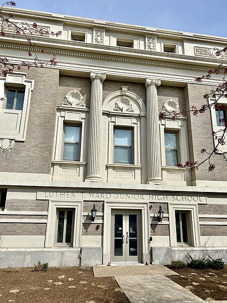
English: Built in 1909, this Classical Revival-style building was designed by Eames and Young to serve as the Women’s Art Academy, founded by businessman and magazine publisher Edward Gardner Lewis, whom owned a magazine publishing and printing business that sat in a complex of buildings adjacent to the site. In 1915, the building was purchased by the University City Public School District, and became home to Luther T. Ward High School, which was expanded in 1923 and 1926, was converted into a Junior High School in 1930, and closed in 1949. The building then housed various departments of the University City government and facilities for the adjacent Delmar-Harvard Elementary School until 1984, when it was purchased by Washington University in St. Louis and became known as the Lewis Collaborative, a combination of Graduate student art studios and apartments. The building features a buff brick exterior, terra cotta trim, decorative reliefs, fluted ionic columns, window surrounds, a cornice with dentils, pilasters, and banded trim at the original building, and simpler wings to the rear. The building is a contributing structure in the University City Plaza Historic District, listed on the National Register of Historic Places in 1975, and remains in use by the Lewis Collaborative. |
| Date | |
| Source | https://www.flickr.com/photos/59081381@N03/53268210889/ |
| Author | w_lemay |
| Camera location | | View this and other nearby images on: OpenStreetMap |
|---|
Licensing
[edit]
This file is licensed under the Creative Commons Attribution-Share Alike 2.0 Generic license.
- You are free:
- to share – to copy, distribute and transmit the work
- to remix – to adapt the work
- Under the following conditions:
- attribution – You must give appropriate credit, provide a link to the license, and indicate if changes were made. You may do so in any reasonable manner, but not in any way that suggests the licensor endorses you or your use.
- share alike – If you remix, transform, or build upon the material, you must distribute your contributions under the same or compatible license as the original.
| This image was originally posted to Flickr by w_lemay at https://flickr.com/photos/59081381@N03/53268210889. It was reviewed on 21 November 2023 by FlickreviewR 2 and was confirmed to be licensed under the terms of the cc-by-sa-2.0. |
File history
Click on a date/time to view the file as it appeared at that time.
| Date/Time | Thumbnail | Dimensions | User | Comment | |
|---|---|---|---|---|---|
| current | 21:54, 21 November 2023 | | 3,024 × 4,032 (4.19 MB) | Ser Amantio di Nicolao (talk | contribs) | Uploaded a work by w_lemay from https://www.flickr.com/photos/59081381@N03/53268210889/ with UploadWizard |
You cannot overwrite this file.
File usage on Commons
There are no pages that use this file.