File:Former Yugoslavia 1991-1995.svg

Původní soubor (soubor SVG, nominální rozměr: 1 832 × 1 142 pixelů, velikost souboru: 108 KB)
Popisky
Popisky
Popis[editovat]
| Popis |
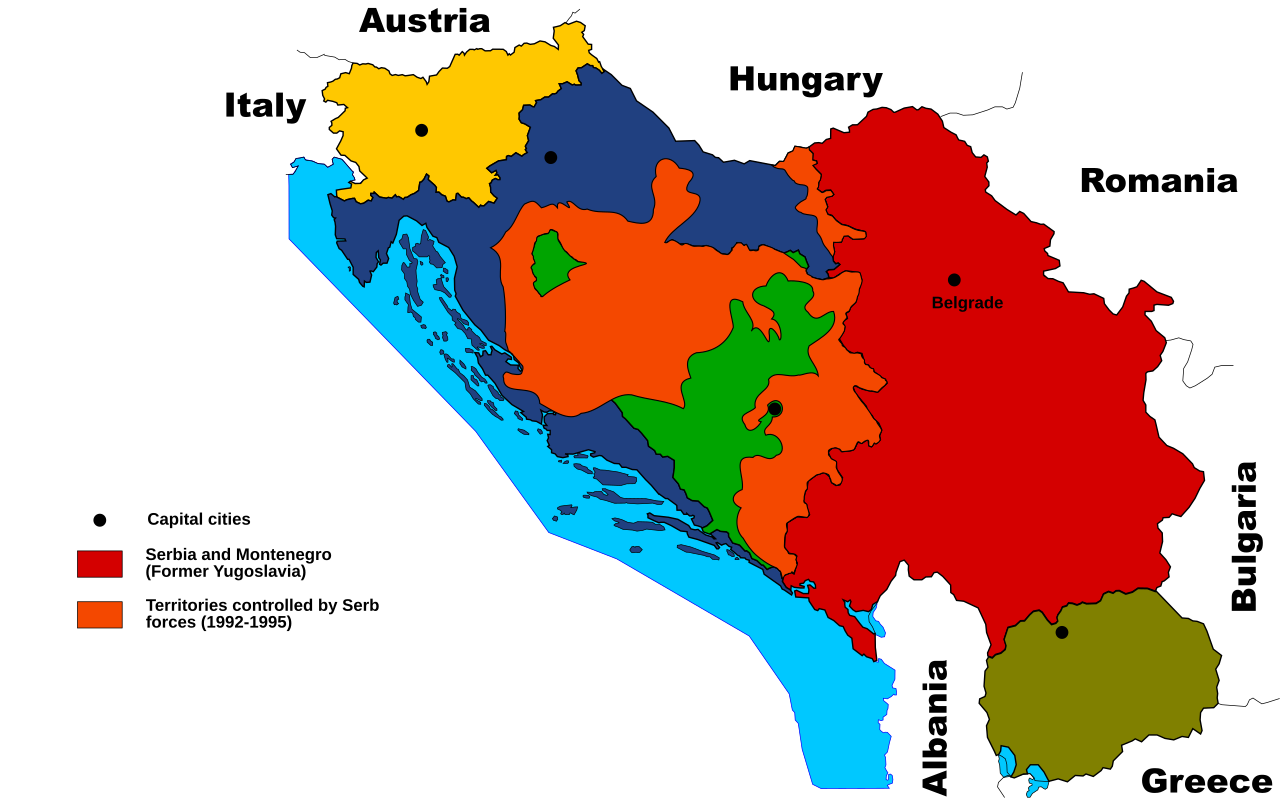
English: Territories of the Republic of Bosnia and Herzegovina and the Republic of Croatia controlled by the Serb forces, after the Operation Corridor (July 1992) in the Yugoslav Wars.
According to the prosecution of War Crimes Tribunal, "Serbian forces" included Yugoslav Army, Serb Territorial Defense of Bosnia and Herzegovina and Croatia, Republic of Srpska Krajina Army, Army of the Republika Srpska, territorial defense of Serbia and Montenegro, Police of Serbia and Police of Republika Srpska, including national security, special police forces of Krajina known as "Martićevci", as well as all Serbian paramilitary forces and volunteer units.[1] Croatia declared independence on June 25, 1991. It was internationally recognized on 15 January 1992 by the United Nations. Bosnia and Herzegovina declared independence on March 5 1992. It was internationally recognized on 22 May 1992 by the United Nations. Serbia and Montenegro proclaimed FR Yugoslavia as a sole successor state of SFR Yugoslavia, on April 27 1992. It remained unrecognized during the conflict (1991-1995). |
| Datum | (UTC) |
| Zdroj | |
| Autor |
|
| Toto je upravený obrázek, což znamená, že byl oproti původní verzi digitálně změněn. Úpravy: used it as a base for another map. Původní verzi je možné zhlédnout zde: Former Yugoslavia 2006.svg. Úpravy provedl Citypeek.
|
Licence[editovat]
| Tento soubor podléhá licenci Creative Commons Uveďte autora-Zachovejte licenci 3.0 Unported | ||
| ||
| Tato licenční šablona byla k tomuto souboru přidána v rámci změny licencování. |

|
Tento dokument smí být kopírován, šířen nebo upravován podle podmínek Svobodné licence GNU pro dokumenty verze 1.2 nebo libovolné vyšší verze publikované nadací Free Software Foundation. Dokument nemá neměnné části ani texty na předním či zadním přebalu. Kopie textu licence je k dispozici v oddíle nazvaném GNU Free Documentation License. |
Původní historie souboru[editovat]
This image is a derivative work of the following images:
- File:Former_Yugoslavia_2006.svg licensed with Cc-by-sa-3.0-migrated, GFDL
- 2006-06-26T11:27:02Z Shazz 1832x1142 (631450 Bytes) ==Authors:== *Based on bitmap by: Paweł Goleniowski [[w:pl:swPawel|swPawel]] *SVG by: ** commons: [[user:Shazz|Shazz]] ** pl.wiki: [[w:pl:user:Shazz|Shazz]] ==Description== * '''pl:''' Mapa byłej Jugosławii, z uwzględnie
- 2006-06-21T08:53:03Z Shazz 1832x1142 (628037 Bytes) ==Authors:== *Based on bitmap by: [[w:pl:swPawel|swPawel]] *SVG by: ** commons: [[user:Shazz|Shazz]] ** pl.wiki: [[w:pl:user:Shazz|Shazz]] ==Description== * '''pl:''' Mapa byłej Jugosławii, z uwzględnieniem podziału Serb
Uploaded with derivativeFX
- ↑ Šešelj ICTY Case information sheet (retrieved 10.07.2009.)
Historie souboru
Kliknutím na datum a čas se zobrazí tehdejší verze souboru.
| Datum a čas | Náhled | Rozměry | Uživatel | Komentář | |
|---|---|---|---|---|---|
| současná | 2. 11. 2011, 14:09 | | 1 832 × 1 142 (108 KB) | Citypeek (diskuse | příspěvky) | Changed the the name of the capital of Serbia |
| 2. 11. 2011, 13:53 |  | 1 832 × 1 142 (108 KB) | Citypeek (diskuse | příspěvky) | minor changes | |
| 17. 10. 2011, 21:33 |  | 1 832 × 1 142 (113 KB) | Citypeek (diskuse | příspěvky) | border added to East-Croatia. | |
| 17. 10. 2011, 15:34 |  | 1 832 × 1 142 (115 KB) | Citypeek (diskuse | příspěvky) | made a few changed as requested | |
| 17. 10. 2011, 06:02 |  | 1 832 × 1 142 (117 KB) | Citypeek (diskuse | příspěvky) | changed colors. | |
| 16. 10. 2011, 12:36 |  | 1 832 × 1 142 (117 KB) | Citypeek (diskuse | příspěvky) | Improvements and correction of errors | |
| 14. 10. 2011, 17:16 |  | 1 832 × 1 142 (152 KB) | Citypeek (diskuse | příspěvky) | == {{int:filedesc}} == {{Information |Description=*Based on bitmap by: Paweł Goleniowski swPawel *SVG by: ** commons: Shazz ** pl.wiki: Shazz == |Source=*File:Former_Yugoslavia_2006.svg |Date=201 |
Tento soubor nemůžete přepsat.
Využití souboru
Na Commons na soubor odkazuje tato stránka:
- File:Former Yugoslavia 2006-2.svg (přesměrování)
Globální využití souboru
Tento soubor využívají následující wiki:
- Využití na en.wikipedia.org
- Využití na mk.wikipedia.org
- Využití na sh.wikipedia.org
- Využití na sr.wikipedia.org
Metadata
- Maps of the Yugoslav wars
- SVG maps of Yugoslavia
- Maps of Greater Serbia
- Maps of the history of Serbia in modern times
- Maps of the history of Montenegro in modern times
- Maps of the history of Republika Srpska
- Maps of the Republic of Serbian Krajina
- Maps of the history of Kosovo in modern times
- Maps of the history of Vojvodina
- Maps of the Bosnian War
- Maps of the Croatian War of Independence
- Maps of the history of the modern Balkans
- Maps of Kosovo and Metohija
- Maps of Republika Srpska (1992-1995)