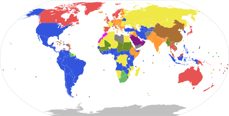
File:Forms of government map.svg

Original file (SVG file, nominally 2,752 × 1,396 pixels, file size: 1.21 MB)
Captions
Captions
Summary[edit]
| DescriptionForms of government map.svg |
English: Please see the legend for more details. |
||
| Map legend |
English (en): World's states coloured by form of government.
Note that several states constitutionally deemed to be multiparty republics are broadly described by outsiders as authoritarian states. This chart aims to represent
de jure form of government, not de facto degree of democracy. |
||
| Date | |||
| Source | Own work | ||
| Creator | |||
| Permission (Reusing this file) |
|
||
| Georeferencing | Georeference the map in Wikimaps Warper If inappropriate please set warp_status = skip to hide. |
Licensing[edit]
- You are free:
- to share – to copy, distribute and transmit the work
- to remix – to adapt the work
- Under the following conditions:
- attribution – You must give appropriate credit, provide a link to the license, and indicate if changes were made. You may do so in any reasonable manner, but not in any way that suggests the licensor endorses you or your use.
- share alike – If you remix, transform, or build upon the material, you must distribute your contributions under the same or compatible license as the original.
File history
Click on a date/time to view the file as it appeared at that time.
| Date/Time | Thumbnail | Dimensions | User | Comment | |
|---|---|---|---|---|---|
| current | 20:28, 16 October 2023 |  | 2,752 × 1,396 (1.21 MB) | ShadZ01 (talk | contribs) | Corrected Kazakhstan as semi-presidential |
| 09:55, 28 January 2022 |  | 2,752 × 1,396 (1.21 MB) | Chubit (talk | contribs) | Updated Burkina Faso | |
| 08:27, 10 January 2022 |  | 2,752 × 1,396 (1.21 MB) | Chubit (talk | contribs) | Update | |
| 09:01, 9 October 2021 |  | 2,752 × 1,396 (1.21 MB) | Chubit (talk | contribs) | ... | |
| 10:59, 7 October 2021 |  | 2,752 × 1,396 (1.21 MB) | Chubit (talk | contribs) | Corrected Abkhazia, Artsakh, Northern Cyprus, South Ossetia, and Transnistria | |
| 10:56, 7 October 2021 |  | 2,752 × 1,396 (1.21 MB) | Chubit (talk | contribs) | Uploaded own work with UploadWizard |
You cannot overwrite this file.
File usage on Commons
There are no pages that use this file.
Metadata
This file contains additional information such as Exif metadata which may have been added by the digital camera, scanner, or software program used to create or digitize it. If the file has been modified from its original state, some details such as the timestamp may not fully reflect those of the original file. The timestamp is only as accurate as the clock in the camera, and it may be completely wrong.
| Short title | World Map |
|---|---|
| Width | 2751.8936 |
| Height | 1396.033 |
