File:Fourpeaked-map1.jpg
Przejdź do nawigacji
Przejdź do wyszukiwania

Rozmiar podglądu – 684 × 599 pikseli. Inne rozdzielczości: 274 × 240 pikseli | 548 × 480 pikseli.
Rozmiar pierwotny (800 × 701 pikseli, rozmiar pliku: 82 KB, typ MIME: image/jpeg)
Podpisy
Podpisy
Dodaj jednolinijkowe objaśnienie tego, co ten plik pokazuje
Opis
[edytuj]
| Opis |
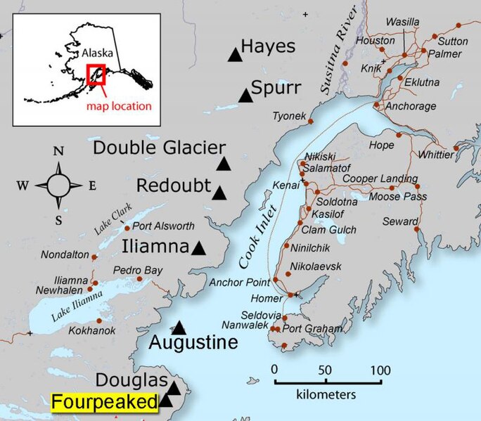
English: AVO map shows the location of Fourpeaked volcano |
| Źródło | Map created by Seth Snedigar and Janet Schaafer for the United States Geological Survey's Alaska Volcano Observatory and the Alaska Division of Geological & Geophysical Surveys |
| Autor | Seth Snedigar and Janet Schaafer for the United States Geological Survey's Alaska Volcano Observatory and the Alaska Division of Geological & Geophysical Surveys |
Licencja
[edytuj]
Ta grafika została utworzona przez pracownika Służby Geologicznej Stanów Zjednoczonych, agencji Departamentu Zasobów Wewnętrznych Stanów Zjednoczonych podczas wykonywania czynności służbowych. Jako utwór Rządu Federalnego Stanów Zjednoczonych, grafika ta znajduje się w domenie publicznej.
|
Oryginalny rejestr przesyłania
[edytuj]
Na Commons przeniósł z en.wikipedia użytkownik Magnus Manske z pomocą narzędzia CommonsHelper.
Oryginalna strona opisu była tutaj. Wszystkie poniższe nazwy użytkowników odwołują się do en.wikipedia.
- 2006-09-23 04:05 Michaelh2001 280×246× (18956 bytes) {{PD-USGov}}
Historia pliku
Kliknij na odpowiedniej dacie/czasie, aby zobaczyć wersję pliku z tamtego okresu.
| Data/czas | Miniatura | Wymiary | Użytkownik | Opis | |
|---|---|---|---|---|---|
| aktualny | 12:14, 9 lip 2011 | | 800 × 701 (82 KB) | Tholme (dyskusja | edycje) | Higher resolution from [http://archive.reefcentral.com/forums/showthread.php?t=937952] |
| 03:25, 18 lut 2011 |  | 280 × 246 (19 KB) | File Upload Bot (Magnus Manske) (dyskusja | edycje) | {{BotMoveToCommons|en.wikipedia|year={{subst:CURRENTYEAR}}|month={{subst:CURRENTMONTHNAME}}|day={{subst:CURRENTDAY}}}} {{Information |Description={{en|AVO map shows the location of Fourpeaked volcano}} |Source=Transferred from [http://en.wikipedia.org en |
Nie możesz nadpisać tego pliku.
Lokalne wykorzystanie pliku
Poniższa strona korzysta z tego pliku:
- File:Fourpeaked-map1.jpg.JPG (przekierowanie do pliku)
Globalne wykorzystanie pliku
Ten plik jest wykorzystywany także w innych projektach wiki:
- Wykorzystanie na en.wikipedia.org
- Wykorzystanie na es.wikipedia.org
- Wykorzystanie na it.wikipedia.org
- Wykorzystanie na nl.wikipedia.org
- Wykorzystanie na pl.wikipedia.org
- Wykorzystanie na ur.wikipedia.org
- Wykorzystanie na www.wikidata.org
Metadane
Kategorie:
- Maps of Fourpeaked volcano
- Active volcanoes
- Aleutian Range
- Maps of Kenai Peninsula Borough, Alaska
- Stratovolcanoes
- Maps of Alaska volcanoes
- Maps of Mount Douglas (Alaska)
- Maps of Mount Redoubt (Alaska)
- Mount Spurr
- Mount Hayes, Alaska
- Maps of Mount Iliamna
- Maps of Augustine Island
- Maps of the Kenai Peninsula
- Iliamna Lake
- Maps of Cook Inlet
- Nanwalek, Alaska