File:Francafrique map.png
Aller à la navigation
Aller à la recherche

Taille de cet aperçu : 800 × 579 pixels. Autres résolutions : 320 × 231 pixels | 640 × 463 pixels | 1 024 × 741 pixels | 1 280 × 926 pixels | 2 560 × 1 852 pixels | 4 463 × 3 228 pixels.
Fichier d’origine (4 463 × 3 228 pixels, taille du fichier : 5,3 Mio, type MIME : image/png)
Légendes
Légendes
Ajoutez en une ligne la description de ce que représente ce fichier
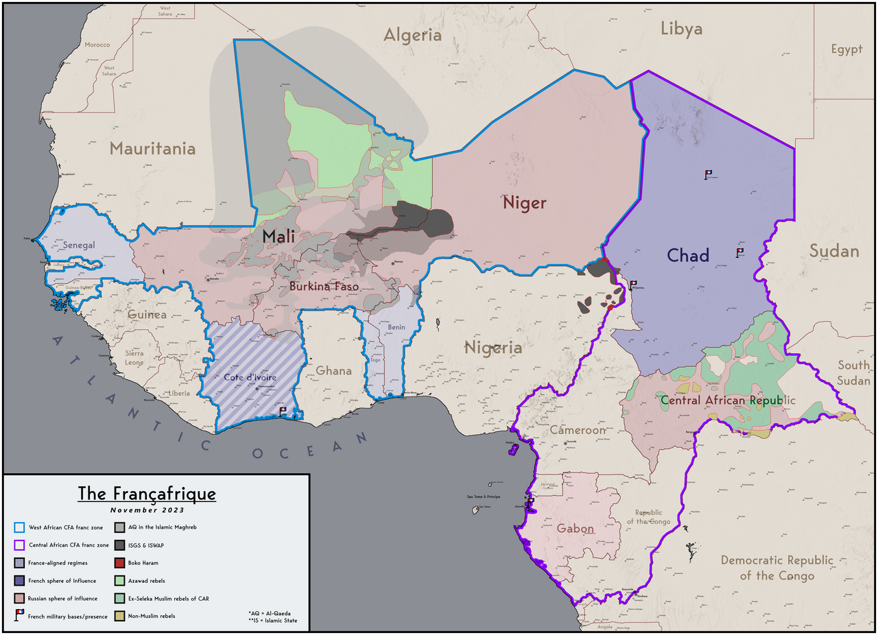
Map of the Francafrique
Description
[modifier]
| Description |
English: Map of the French and Russian spheres of influence in west Africa |
| Date | |
| Source | Travail personnel |
| Auteur | Abdurrahman AbdulMoneim |
Conditions d’utilisation
[modifier]
Moi, en tant que détenteur des droits d’auteur sur cette œuvre, je la publie sous la licence suivante :
Ce fichier est sous la licence Creative Commons Attribution – Partage dans les Mêmes Conditions 4.0 International.
- Vous êtes libre :
- de partager – de copier, distribuer et transmettre cette œuvre
- d’adapter – de modifier cette œuvre
- Sous les conditions suivantes :
- paternité – Vous devez donner les informations appropriées concernant l'auteur, fournir un lien vers la licence et indiquer si des modifications ont été faites. Vous pouvez faire cela par tout moyen raisonnable, mais en aucune façon suggérant que l’auteur vous soutient ou approuve l’utilisation que vous en faites.
- partage à l’identique – Si vous modifiez, transformez, ou vous basez sur cette œuvre, vous devez distribuer votre contribution sous la même licence ou une licence compatible avec celle de l’original.
Historique du fichier
Cliquer sur une date et heure pour voir le fichier tel qu'il était à ce moment-là.
| Date et heure | Vignette | Dimensions | Utilisateur | Commentaire | |
|---|---|---|---|---|---|
| actuel | 15 novembre 2023 à 20:30 | | 4 463 × 3 228 (5,3 Mio) | Userd898 (d | contributions) | correct version for november |
| 15 novembre 2023 à 20:16 |  | 4 463 × 3 228 (5,33 Mio) | Userd898 (d | contributions) | updated for november of 2023 | |
| 22 juin 2023 à 14:04 |  | 4 463 × 3 228 (5,32 Mio) | Userd898 (d | contributions) | Uploaded own work with UploadWizard |
Vous ne pouvez pas remplacer ce fichier.
Utilisations locales du fichier
La page suivante utilise ce fichier :
Utilisations du fichier sur d’autres wikis
Les autres wikis suivants utilisent ce fichier :
- Utilisation sur en.wikipedia.org
- Utilisation sur fr.wikipedia.org
- Utilisation sur pl.wikipedia.org
Métadonnées
Catégories :
- CFA franc
- Maps of West Africa
- Relations of Africa and France
- Russian imperialism
- Islamic State of Iraq and the Levant
- Central African Republic Civil War (2012–present)
- Maps of Northern Mali conflict (2012-)
- Current civil wars maps
- Maps of the Central African Republic Civil War (2012–present)
- Maps of ongoing armed conflicts in Africa