File:France Pays bretons map.svg
跳至導覽
跳至搜尋

此 SVG 檔案的 PNG 預覽的大小:783 × 599 像素。 其他解析度:314 × 240 像素 | 627 × 480 像素 | 1,004 × 768 像素 | 1,280 × 980 像素 | 2,560 × 1,959 像素 | 946 × 724 像素。
原始檔案 (SVG 檔案,表面大小:946 × 724 像素,檔案大小:1,017 KB)
說明
說明
添加單行說明來描述出檔案所代表的內容
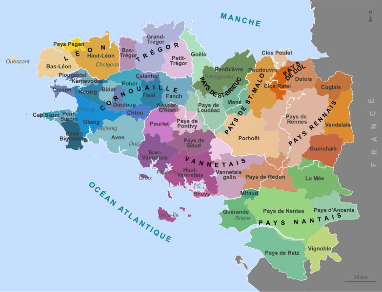
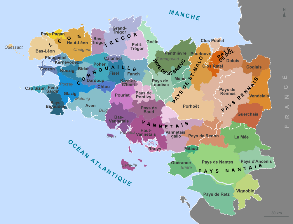
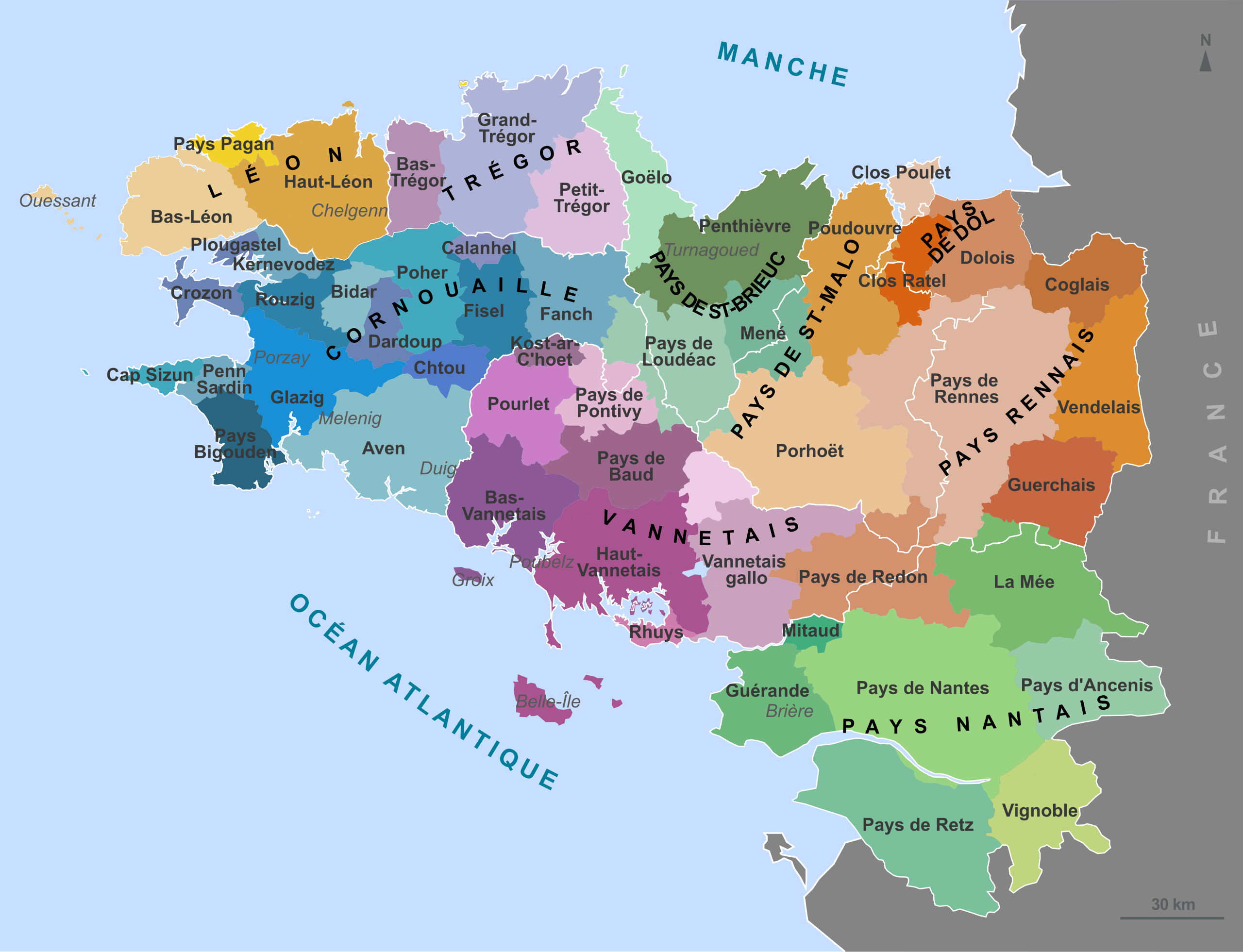
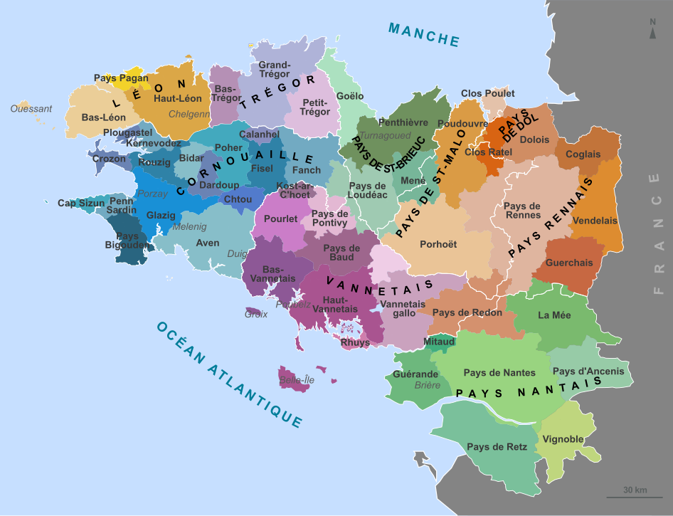
Traditional regions of Brittany
摘要[編輯]
| 描述 |
English: Map of the traditional regions of Brittany (France) Français : Carte des pays traditionnels bretons. Brezhoneg: Kartenn broioù hengounel Breizh (e galleg) |
||
| 日期 | (UTC) | ||
| 來源 | |||
| 作者 |
|
||
| 授權許可 (重用此檔案) |
我,本作品的著作權持有者,決定用以下授權條款發佈本作品:
您可以選擇您需要的授權條款。 |
||
| 其他版本 |
Derivative works of this file: Bretagne historic location map.svg
[]
|


|
This SVG file contains embedded text that can be translated into your language, using any capable SVG editor, text editor or the SVG Translate tool. For more information see: About translating SVG files. |
原始上傳日誌[編輯]
This image is a derivative work of the following images:
- File:France_Pays_bretons_map.jpg licensed with Cc-by-sa-3.0,2.5,2.0,1.0, GFDL
- 2010-03-31T12:59:09Z Pethrus 1500x1189 (835023 Bytes) {{Information |Description={{en|Map of the traditionnal regions of Bretagne (France)}}{{fr|Carte des pays traditionnels bretons}} |Source=[http://www.geobreizh.com www.geobreizh.com], Mikael Bodlore-Penlaez |Date=2010-03-30 |
Uploaded with derivativeFX
檔案歷史
點選日期/時間以檢視該時間的檔案版本。
| 日期/時間 | 縮圖 | 尺寸 | 用戶 | 備註 | |
|---|---|---|---|---|---|
| 目前 | 2010年4月23日 (五) 08:10 | | 946 × 724(1,017 KB) | Pethrus(對話 | 貢獻) | Border fixed. |
| 2010年4月22日 (四) 13:09 |  | 946 × 724(1,017 KB) | Pethrus(對話 | 貢獻) | Name fix. | |
| 2010年4月22日 (四) 12:51 |  | 946 × 724(1,017 KB) | Pethrus(對話 | 貢獻) | {{Information |Description={{en|Map of the traditionnal regions of Brittany (France)}}{{fr|Carte des pays traditionnels bretons.}} |Source=*File:France_Pays_bretons_map.jpg {{inkscape}} |Date=2010-04-22 12:50 (UTC) |Author=*[[:File:France_Pays_breto |
無法覆蓋此檔案。
檔案用途
下列8個頁面有用到此檔案:
全域檔案使用狀況
以下其他 wiki 使用了這個檔案:
- an.wikipedia.org 的使用狀況
- ca.wikipedia.org 的使用狀況
- de.wikipedia.org 的使用狀況
- el.wikipedia.org 的使用狀況
- en.wikipedia.org 的使用狀況
- eo.wikipedia.org 的使用狀況
- es.wikipedia.org 的使用狀況
- fr.wikipedia.org 的使用狀況
- Duché de Bretagne
- Drapeau de la Bretagne
- Pays Bigouden
- Porhoët
- Pays de Retz
- Pays de la Mée
- Saint-Nicolas-du-Pélem
- Haute-Bretagne
- Penthièvre
- Goëlo
- Pays de Bretagne
- Kost ar c'hoad
- Poudouvre
- Pays Pourlet
- Pays Glazik
- Gilles de Rais
- Coglais
- Wikipédia:Atelier graphique/Cartes/Archives/avril 2010
- Presqu'île guérandaise
- Pays Fañch
- Mitau
- Pays du Vignoble nantais
- Pays de Guérande
- Vendelais
- Guerchais
- Portail:Histoire de Bretagne
- Portail:Histoire de Bretagne/Présentation
- Pays Chelgen
- Kost ar c'hoad (pays)
檢視此檔案的更多全域使用狀況。