File:France TGV.png

Fichier d’origine (4 130 × 4 409 pixels, taille du fichier : 2,33 Mio, type MIME : image/png)
Légendes
Légendes
Description[modifier]
| Description |
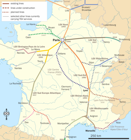
English: Map of French TGV lines in use and under construction. Original intention is to show the location of the Rhin-Rhone TGV. |
| Date | |
| Source | Travail personnel |
| Auteur | Classical geographer |
Background is File:France_blank.svg; north arrow used is File:Arrow North CFCF.svg. For information on TGV lines in general , I used File:Carte TGV.svg; for the Rhin-Rhone project in particular, I found this map to be the most useful, although this one is also not half bad. This website tries to give a map that puts the line into a pan-European perspective, but here I have made no such attempt: no German or UK lines, and in Belgium only the line to Lille are shown.

|
Cette image (de type transport map) devrait être recréée dans un format vectoriel, en tant que fichier SVG. Cela offrirait plusieurs avantages : voir Commons:Media for cleanup pour plus d'informations. Si une version SVG de cette image est déjà disponible, merci de bien vouloir l'envoyer. Après cela, remplacez ce modèle par {{vector version available|nouveau nom d'image.svg}}.
|
Conditions d’utilisation[modifier]
- Vous êtes libre :
- de partager – de copier, distribuer et transmettre cette œuvre
- d’adapter – de modifier cette œuvre
- Sous les conditions suivantes :
- paternité – Vous devez donner les informations appropriées concernant l'auteur, fournir un lien vers la licence et indiquer si des modifications ont été faites. Vous pouvez faire cela par tout moyen raisonnable, mais en aucune façon suggérant que l’auteur vous soutient ou approuve l’utilisation que vous en faites.
- partage à l’identique – Si vous modifiez, transformez, ou vous basez sur cette œuvre, vous devez distribuer votre contribution sous la même licence ou une licence compatible avec celle de l’original.

|
Vous avez la permission de copier, distribuer et modifier ce document selon les termes de la GNU Free Documentation License version 1.2 ou toute version ultérieure publiée par la Free Software Foundation, sans sections inaltérables, sans texte de première page de couverture et sans texte de dernière page de couverture. Un exemplaire de la licence est inclus dans la section intitulée GNU Free Documentation License. |
Historique du fichier
Cliquer sur une date et heure pour voir le fichier tel qu'il était à ce moment-là.
| Date et heure | Vignette | Dimensions | Utilisateur | Commentaire | |
|---|---|---|---|---|---|
| actuel | 1 août 2019 à 12:38 | | 4 130 × 4 409 (2,33 Mio) | Borvan53 (d | contributions) | Update with Nimes-Montpellier Line finished |
| 3 septembre 2017 à 11:38 |  | 4 130 × 4 409 (1,68 Mio) | Classical geographer (d | contributions) | Updated LGV Bretagne and Sud Europe, adjusted Montpellier/Nimes date to 2018. | |
| 18 juillet 2016 à 13:14 |  | 4 127 × 4 428 (1,68 Mio) | Classical geographer (d | contributions) | LGV Est opens; other smaller updates following information at User_talk:Classical_geographer#File:France_TGV.png. | |
| 15 juillet 2013 à 15:19 |  | 2 484 × 2 656 (936 kio) | Classical geographer (d | contributions) | See User_talk:Classical_geographer#File:France_TGV.png for discussion of changes. | |
| 17 octobre 2012 à 11:34 |  | 1 446 × 1 547 (442 kio) | Classical geographer (d | contributions) | Added opening dates for existing lines. Removed any projected opening date for Lyon-Turin. | |
| 3 octobre 2012 à 19:10 |  | 2 482 × 2 663 (1,79 Mio) | Classical geographer (d | contributions) | Smaller. | |
| 3 octobre 2012 à 19:07 |  | 6 290 × 6 647 (2,37 Mio) | Classical geographer (d | contributions) | Updates to construction years. Distinguishing between under construction and planned. | |
| 7 mars 2012 à 21:16 |  | 2 000 × 2 146 (1,34 Mio) | Classical geographer (d | contributions) | Updated LGV Rhin-Rhône; added Nîmes branch; slightly adjusted LGV Est. | |
| 22 juillet 2011 à 18:25 |  | 2 000 × 2 140 (1,37 Mio) | Classical geographer (d | contributions) | Tours-Bordeaux now to open all at once in 2017. | |
| 15 janvier 2011 à 22:32 |  | 2 000 × 2 150 (1,39 Mio) | Classical geographer (d | contributions) | Had forgotten to resize. |
Vous ne pouvez pas remplacer ce fichier.
Utilisations locales du fichier
Les 17 pages suivantes utilisent ce fichier :
- TGV
- Top 200 transport map images that should use vector graphics
- User:Chumwa/OgreBot/Potential transport maps/2016 July 11-20
- User:Chumwa/OgreBot/Potential transport maps/2017 September 1-10
- User:Chumwa/OgreBot/Potential transport maps/2019 August 1-10
- User:Chumwa/OgreBot/Public transport information/2016 July 11-20
- User:Chumwa/OgreBot/Public transport information/2017 September 1-10
- User:Chumwa/OgreBot/Public transport information/2019 August 1-10
- User:Chumwa/OgreBot/Transport Maps/2016 July 11-20
- User:Chumwa/OgreBot/Transport Maps/2017 September 1-10
- User:Chumwa/OgreBot/Transport Maps/2019 August 1-10
- User:Chumwa/OgreBot/Travel and communication maps/2016 July 11-20
- User:Chumwa/OgreBot/Travel and communication maps/2017 September 1-10
- User:Chumwa/OgreBot/Travel and communication maps/2019 August 1-10
- User:Classical geographer
- Category:Contournement Nimes-Montpellier
- Category:TGV
Utilisations du fichier sur d’autres wikis
Les autres wikis suivants utilisent ce fichier :
- Utilisation sur cs.wikipedia.org
- Utilisation sur de.wikipedia.org
- Utilisation sur en.wikipedia.org
- Utilisation sur en.wikibooks.org
- Utilisation sur eo.wikipedia.org
- Utilisation sur es.wikipedia.org
- Utilisation sur fr.wikipedia.org
- Utilisation sur he.wikipedia.org
- Utilisation sur hu.wikipedia.org
- TGV
- TGV Atlantique
- TGV Sud-Est
- TGV Réseau
- TGV Duplex
- Acela Express
- Thalys PBKA
- TGV POS
- Thalys PBA
- Eurostar
- TGV-állomások listája
- TGV La Poste
- Nagysebességű vasút
- LGV Méditerranée
- LGV Est
- Sablon:TGV
- Thalys
- LGV Interconnexion Est
- LGV Sud-Est
- LGV Atlantique
- LGV Rhône-Alpes
- LGV Nord
- LGV Perpignan–Figueres
- LGV Rhin-Rhône
- LGV Bretagne-Pays de la Loire
- LGV Provence-Alpes-Côte d’Azur
Voir davantage sur l’utilisation globale de ce fichier.