File:France TGV.png

File originale (4 130 × 4 409 pixel, dimensione del file: 2,33 MB, tipo MIME: image/png)
Didascalie
Didascalie
Dettagli[modifica]
| Descrizione |
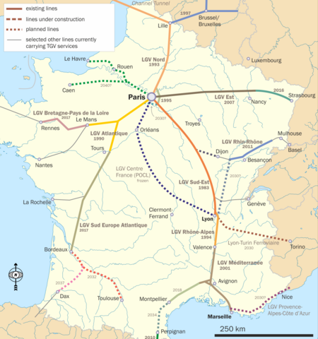
English: Map of French TGV lines in use and under construction. Original intention is to show the location of the Rhin-Rhone TGV. |
| Data | |
| Fonte | Opera propria |
| Autore | Classical geographer |
Background is File:France_blank.svg; north arrow used is File:Arrow North CFCF.svg. For information on TGV lines in general , I used File:Carte TGV.svg; for the Rhin-Rhone project in particular, I found this map to be the most useful, although this one is also not half bad. This website tries to give a map that puts the line into a pan-European perspective, but here I have made no such attempt: no German or UK lines, and in Belgium only the line to Lille are shown.

|
Questa immagine (categorizzazione automatica: transport map) o tutte le immagini in questa categoria o galleria dovrebbero essere ricreate usando grafica vettoriale come file SVG. Questo offre diversi vantaggi: vedi Commons:Media for cleanup per maggiori informazioni. Se è disponibile una versione in formato SVG di questa immagine, per favore caricala. Dopo aver caricato un file SVG, sostituisci questo avviso con il template {{Vector version available|nome_immagine.svg}}.
|
Licenza[modifica]
- Tu sei libero:
- di condividere – di copiare, distribuire e trasmettere quest'opera
- di modificare – di adattare l'opera
- Alle seguenti condizioni:
- attribuzione – Devi fornire i crediti appropriati, un collegamento alla licenza e indicare se sono state apportate modifiche. Puoi farlo in qualsiasi modo ragionevole, ma non in alcun modo che suggerisca che il licenziante approvi te o il tuo uso.
- condividi allo stesso modo – Se remixi, trasformi o sviluppi il materiale, devi distribuire i tuoi contributi in base alla stessa licenza o compatibile all'originale.

|
È permesso copiare, distribuire e/o modificare questo documento in base ai termini della GNU Free Documentation License, Versione 1.2 o successive pubblicata dalla Free Software Foundation; senza alcuna sezione non modificabile, senza testo di copertina e senza testo di quarta di copertina. Una copia della licenza è inclusa nella sezione intitolata Testo della GNU Free Documentation License. |
Cronologia del file
Fare clic su un gruppo data/ora per vedere il file come si presentava nel momento indicato.
| Data/Ora | Miniatura | Dimensioni | Utente | Commento | |
|---|---|---|---|---|---|
| attuale | 12:38, 1 ago 2019 | | 4 130 × 4 409 (2,33 MB) | Borvan53 (discussione | contributi) | Update with Nimes-Montpellier Line finished |
| 11:38, 3 set 2017 |  | 4 130 × 4 409 (1,68 MB) | Classical geographer (discussione | contributi) | Updated LGV Bretagne and Sud Europe, adjusted Montpellier/Nimes date to 2018. | |
| 13:14, 18 lug 2016 |  | 4 127 × 4 428 (1,68 MB) | Classical geographer (discussione | contributi) | LGV Est opens; other smaller updates following information at User_talk:Classical_geographer#File:France_TGV.png. | |
| 15:19, 15 lug 2013 |  | 2 484 × 2 656 (936 KB) | Classical geographer (discussione | contributi) | See User_talk:Classical_geographer#File:France_TGV.png for discussion of changes. | |
| 11:34, 17 ott 2012 |  | 1 446 × 1 547 (442 KB) | Classical geographer (discussione | contributi) | Added opening dates for existing lines. Removed any projected opening date for Lyon-Turin. | |
| 19:10, 3 ott 2012 |  | 2 482 × 2 663 (1,79 MB) | Classical geographer (discussione | contributi) | Smaller. | |
| 19:07, 3 ott 2012 |  | 6 290 × 6 647 (2,37 MB) | Classical geographer (discussione | contributi) | Updates to construction years. Distinguishing between under construction and planned. | |
| 21:16, 7 mar 2012 |  | 2 000 × 2 146 (1,34 MB) | Classical geographer (discussione | contributi) | Updated LGV Rhin-Rhône; added Nîmes branch; slightly adjusted LGV Est. | |
| 18:25, 22 lug 2011 |  | 2 000 × 2 140 (1,37 MB) | Classical geographer (discussione | contributi) | Tours-Bordeaux now to open all at once in 2017. | |
| 22:32, 15 gen 2011 |  | 2 000 × 2 150 (1,39 MB) | Classical geographer (discussione | contributi) | Had forgotten to resize. |
Impossibile sovrascrivere questo file.
Utilizzo del file
Le seguenti 17 pagine usano questo file:
- TGV
- Top 200 transport map images that should use vector graphics
- User:Chumwa/OgreBot/Potential transport maps/2016 July 11-20
- User:Chumwa/OgreBot/Potential transport maps/2017 September 1-10
- User:Chumwa/OgreBot/Potential transport maps/2019 August 1-10
- User:Chumwa/OgreBot/Public transport information/2016 July 11-20
- User:Chumwa/OgreBot/Public transport information/2017 September 1-10
- User:Chumwa/OgreBot/Public transport information/2019 August 1-10
- User:Chumwa/OgreBot/Transport Maps/2016 July 11-20
- User:Chumwa/OgreBot/Transport Maps/2017 September 1-10
- User:Chumwa/OgreBot/Transport Maps/2019 August 1-10
- User:Chumwa/OgreBot/Travel and communication maps/2016 July 11-20
- User:Chumwa/OgreBot/Travel and communication maps/2017 September 1-10
- User:Chumwa/OgreBot/Travel and communication maps/2019 August 1-10
- User:Classical geographer
- Category:Contournement Nimes-Montpellier
- Category:TGV
Utilizzo globale del file
Anche i seguenti wiki usano questo file:
- Usato nelle seguenti pagine di cs.wikipedia.org:
- Usato nelle seguenti pagine di de.wikipedia.org:
- Usato nelle seguenti pagine di en.wikipedia.org:
- Usato nelle seguenti pagine di en.wikibooks.org:
- Usato nelle seguenti pagine di eo.wikipedia.org:
- Usato nelle seguenti pagine di es.wikipedia.org:
- Usato nelle seguenti pagine di fr.wikipedia.org:
- Usato nelle seguenti pagine di he.wikipedia.org:
- Usato nelle seguenti pagine di hu.wikipedia.org:
- TGV
- TGV Atlantique
- TGV Sud-Est
- TGV Réseau
- TGV Duplex
- Acela Express
- Thalys PBKA
- TGV POS
- Thalys PBA
- Eurostar
- TGV-állomások listája
- TGV La Poste
- Nagysebességű vasút
- LGV Méditerranée
- LGV Est
- Sablon:TGV
- Thalys
- LGV Interconnexion Est
- LGV Sud-Est
- LGV Atlantique
- LGV Rhône-Alpes
- LGV Nord
- LGV Perpignan–Figueres
- LGV Rhin-Rhône
- LGV Bretagne-Pays de la Loire
- LGV Provence-Alpes-Côte d’Azur
Visualizza l'utilizzo globale di questo file.