File:France map Lambert-93 topographic-blank.svg
ナビゲーションに移動
検索に移動

この SVG ファイルのこの PNG プレビューのサイズ: 632 × 600 ピクセル. その他の解像度: 253 × 240 ピクセル | 506 × 480 ピクセル | 809 × 768 ピクセル | 1,079 × 1,024 ピクセル | 2,158 × 2,048 ピクセル | 2,000 × 1,898 ピクセル。
元のファイル (SVG ファイル、2,000 × 1,898 ピクセル、ファイルサイズ: 1.56メガバイト)
キャプション
キャプション
このファイルの内容を1行で記述してください
概要
[編集]| カメラの位置 | | 以下のサービスでこの位置を確認する: オープンストリートマップ |
|---|
| 解説 |
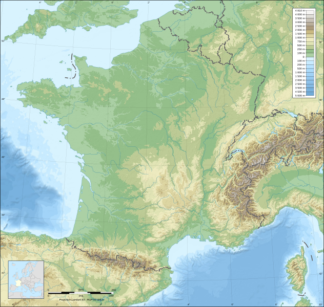
English: Blank topographic map of France in the official Lambert-93 projection.
Note: The background map is a raster image embedded in the SVG file. Français : Carte topographique vierge de la France suivant la projection officielle Lambert-93. Note : Le fond de carte est une image bitmap embarquée dans le fichier SVG. Lambert-93 projection ; RGF-93 datum
|
||
| 日付 | |||
| 原典 |
Own work
|
||
| 作者 | Eric Gaba (Sting - fr:Sting) | ||
| 許可 (ファイルの再利用) |
|
||
| その他のバージョン |
このファイルの派生的著作物:
Same map but with topography and bathymetry:
|
||
| SVG 開発 | このSVG地図は埋込み文を用いており,テキストエディタを用いて容易に翻訳することができますいます。 |


ライセンス
[編集]
この作品の著作権者である私は、この作品を以下のライセンスで提供します。

|
この文書は、フリーソフトウェア財団発行のGNUフリー文書利用許諾書 (GNU Free Documentation License) 1.2またはそれ以降のバージョンの規約に基づき、複製や再配布、改変が許可されます。不可変更部分、表紙、背表紙はありません。このライセンスの複製は、GNUフリー文書利用許諾書という章に含まれています。 |
This file is licensed under the Creative Commons Attribution-Share Alike 4.0 International, 3.0 Unported, 2.5 Generic, 2.0 Generic and 1.0 Generic license.
- あなたは以下の条件に従う場合に限り、自由に
- 共有 – 本作品を複製、頒布、展示、実演できます。
- 再構成 – 二次的著作物を作成できます。
- あなたの従うべき条件は以下の通りです。
- 表示 – あなたは適切なクレジットを表示し、ライセンスへのリンクを提供し、変更があったらその旨を示さなければなりません。これらは合理的であればどのような方法で行っても構いませんが、許諾者があなたやあなたの利用行為を支持していると示唆するような方法は除きます。
- 継承 – もしあなたがこの作品をリミックスしたり、改変したり、加工した場合には、あなたはあなたの貢献部分を元の作品とこれと同一または互換性があるライセンスの下に頒布しなければなりません。
あなたは上記のライセンスから、どれか一つ以上を選択できます。
ファイルの履歴
過去の版のファイルを表示するには、その版の日時をクリックしてください。
| 日付と時刻 | サムネイル | 寸法 | 利用者 | コメント | |
|---|---|---|---|---|---|
| 現在の版 | 2017年10月19日 (木) 15:36 | | 2,000 × 1,898 (1.56メガバイト) | Sting (トーク | 投稿記録) | No borders over the Lake of Constance |
| 2008年11月13日 (木) 17:24 |  | 2,000 × 1,898 (1.56メガバイト) | Sting (トーク | 投稿記録) | + boundary for Channel Islands ; - canals | |
| 2008年10月1日 (水) 04:59 |  | 2,000 × 1,898 (1.6メガバイト) | Sting (トーク | 投稿記録) | == Summary == {{Location|46|15|00|N|02|06|00|E|scale:10000000}} <br/> {{Information |Description={{en|Blank topographic map of France in the official Lambert-93 projection.}} {{fr|Carte topographique vierge de la France suiva |
このファイルは上書きできません。
ファイルの使用状況
以下の 20 ページがこのファイルを使用しています:
- User:Linguae
- User:Sting/Gallery: Regional maps
- File:1202 French campaign.png
- File:DA MASSALIA A ILERDA 49 aC.png
- File:DA ROMA A MASSALIA 49 aC.png
- File:France map Lambert-93-Maximum altitude.svg
- File:France map Lambert-93-blank.svg
- File:France map Lambert-93 topographic-ancient Roman roads.svg
- File:France map Lambert-93 topographic-blank.svg
- File:France map Lambert-93 topographic with regions-blank.svg
- File:France map Lambert-93 topographic with regions and departements-blank.svg
- File:France map Lambert-93 with regions-blank.svg
- File:France map Lambert-93 with regions and departments-blank.svg
- File:France map Lambert-93 with regions and departments polygons-blank.svg
- File:France map Lambert-93 with rivers-blank.svg
- File:France map Lambert-93 with rivers and regions-blank.svg
- File:Henry II Final Campaign.png
- File:MARCIA DI ANNIBALE DA NOVA CARTHAGO A ITALIA 218 aC.png
- File:Normandy campaign 1204.png
- Template:Other versions/France map Lambert-93
グローバルなファイル使用状況
以下に挙げる他のウィキがこの画像を使っています:
- ast.wikipedia.org での使用状況
- ca.wikipedia.org での使用状況
- de.wikipedia.org での使用状況
- es.wikipedia.org での使用状況
- fr.wikipedia.org での使用状況
- fr.wikibooks.org での使用状況
- fr.wikinews.org での使用状況
- Utilisateur:Grondin/Météo
- Météo en France : une journée partagée entre instabilité et soleil le 9 mars 2009
- Météo en France : Les prévisions pour le 10 mars 2009
- Météo en France : amélioration pour le 11 mars 2009
- Météo en France : les prévisions pour le 12 mars 2009
- Météo en France : le soleil s'installera le 13 mars 2009
- Météo en France : les prévisions pour le 14 mars 2009
- Météo en France : Les prévisions pour le 15 mars 2009
- Météo en France : les prévisions pour le 16 mars 2009
- Météo en France : les prévisions pour le 17 mars 2009
- Météo en France : les prévisions pour le 18 mars 2009
- Météo en France : les prévisions pour le 19 mars 2009
- Météo en France : les prévisions pour le 20 mars 2009
- Météo en France : gelées matinales pour le 21 mars 2009
- Météo en France : les prévisions pour le 22 mars 2009
- Météo en France : les prévisions pour le 23 mars 2009
- Météo en France : les prévisions pour le 24 mars 2009
- Météo en France : précipitations sur le nord le 25 mars 2009
- Météo en France : le nord sous les pluies le 26 mars 2009
- Météo en France : la pluie s'installe sur le nord le 27 mars 2009
- Météo en France : pluies, averses orageuses au programme du 28 mars 2009
- Météo en France : entre éclaircies et averses le 29 mars 2009
- Météo en France : gelées matinales pour le 30 mars 2009
- Météo en France : le beau temps s'installe le 31 mars 2009
- Météo en France : intempéries en Méditerranée le 1er avril 2009
- Météo en France : pluies sur le pourtour méditerranéen pour le 2 avril 2009
- Météo en France : les prévisions pour le 3 avril 2009
- Météo en France : prévisions pour le 4 avril 2009
- Météo en France : brouillards matinaux pour le 5 avril 2009
- Météo en France : journée agréable pour le 6 avril 2009
- Utilisateur:Grondin/Tâches/Météo
- Météo en France : perturbations pour le 7 avril 2009
このファイルのグローバル使用状況を表示する。