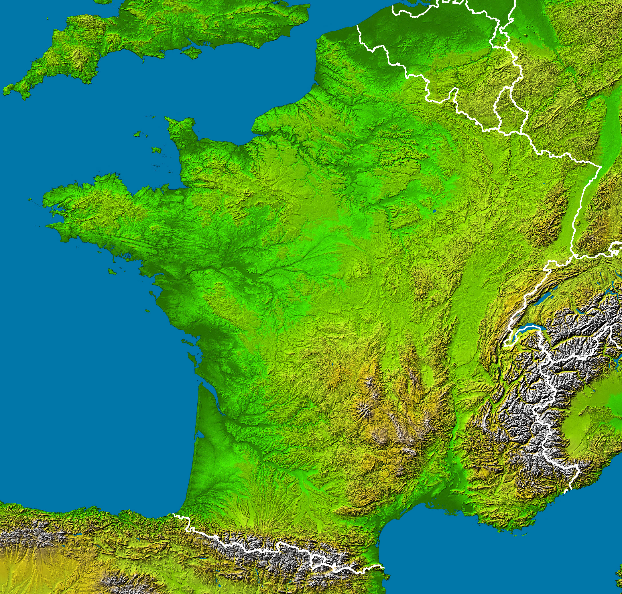
File:France radar 2.jpg
跳转到导航
跳转到搜索
本预览的尺寸:628 × 600像素。 其他分辨率:251 × 240像素 | 503 × 480像素 | 804 × 768像素 | 1,072 × 1,024像素 | 2,172 × 2,074像素。
原始文件 (2,172 × 2,074像素,文件大小:3.13 MB,MIME类型:image/jpeg)
说明
说明
添加一行文字以描述该文件所表现的内容
摘要
[编辑]
en :
- Subject : France viewed by NASA Shuttle radar-imaging ;
- Source : NASA Earth Observatory (modified) ;
- Original image in Wikipedia : Image:France_radar.jpg ;
- This version : Without shadows along the borders, modified by Sting.
- Location: 42 to 51.5 ° North, 5.5 West to 8 ° East
- Orientation: North toward the top, Mercator projection
- Image Data: shaded and colored SRTM elevation model
- Original Data Resolution: 1 arcsecond (~30 meters)
- Date Acquired: February 2000
- Projection équirectangulaire
- top:51.625°
- bottom:42.00°
- left:-5.75°
- right:8.75°
fr :
- Sujet : Image radar de la France vue depuis la navette spatiale, par la NASA ;
- Source : NASA Earth Observatory (modifiée) ;
- Image originale sur Wikipédia : Image:France_radar.jpg ;
- Cette version : Sans ombres le long des frontières, modifiée par Sting.
许可协议
[编辑]
- The purpose of NASA's Earth Observatory is to provide a freely-accessible publication on the Internet where the public can obtain new satellite imagery and scientific information about our home planet. The focus is on Earth's climate and environmental change. In particular, we hope our site is useful to public media and educators. Any and all materials published on the Earth Observatory are freely available for re-publication or re-use, except where copyright is indicated. We ask that NASA's Earth Observatory be given credit for its original materials.
|
|
 | |
| This work was previously under Public Domain, or a Free License. It has been digitally enhanced and/or modified. This derivative work has been (or is hereby) released into the public domain by its author, Sting at the French Wikipedia project. This applies worldwide. 在一些国家这可能不合法;如果是这样的话,那么:
|
文件历史
点击某个日期/时间查看对应时刻的文件。
| 日期/时间 | 缩略图 | 大小 | 用户 | 备注 | |
|---|---|---|---|---|---|
| 当前 | 2006年2月23日 (四) 04:23 | | 2,172 × 2,074(3.13 MB) | Sting(留言 | 贡献) | '''en :''' * '''Subject :''' France viewed by NASA Shuttle radar-imaging ; * '''Source :''' [http://earthobservatory.nasa.gov/Newsroom/NewImages/images.php3?img_id=15360 NASA Earth Observatory] (modified) ; * '''Original image in Wikipedia :''' [[:Image: |
您不可以覆盖此文件。
文件用途
全域文件用途
以下其他wiki使用此文件:
- de.wikipedia.org上的用途
- de.wikinews.org上的用途
- en.wikipedia.org上的用途
- eo.wikipedia.org上的用途
- es.wikipedia.org上的用途
- frp.wikipedia.org上的用途
- fr.wikipedia.org上的用途
- Région naturelle de France
- Discussion:Région naturelle de France
- Utilisateur:Bludwarf
- Utilisateur:Chauki
- Utilisateur:Wikisoft*/Frageoloc
- Utilisateur:Wikisoft*/Paris
- Utilisateur:Wikisoft*/Cartes
- Utilisateur:Wikisoft*/Tests cartes 1
- Discussion utilisateur:Wikisoft*/Tests cartes 1
- Discussion utilisateur:TomKr/Cartographie
- Utilisateur:Wikisoft*/Géobox-Montagnes-France
- Garrigues (région naturelle)
- is.wikipedia.org上的用途
- wuu.wikipedia.org上的用途
- zh.wikipedia.org上的用途