File:Francuskie i brytyjskie forty 1753 1758.jpg
Aller à la navigation
Aller à la recherche
Pas de plus haute résolution disponible.
Francuskie_i_brytyjskie_forty_1753_1758.jpg (457 × 591 pixels, taille du fichier : 179 kio, type MIME : image/jpeg)
Légendes
Légendes
Ajoutez en une ligne la description de ce que représente ce fichier
| Description |
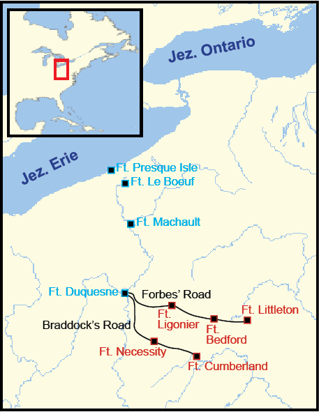
Polski: Mapa pokazuje pozycje francuskich (niebieski) i brytyjskich (czerwony) fortów w latach 1753-1758, oraz przybliżoną trasę Drogi Braddocka (Braddock's Road) i Forbesa (Forbes' Road). |
| Date | (UTC) |
| Source | |
| Auteur |
|
| Cette image a été retouchée, ce qui signifie qu'elle a été modifiée par ordinateur et est différente de l'image d'origine. Liste des modifications : Polish labels, minor graphical edits. L'image d'origine se trouve ici : French British Forts 1753 1758.png:
|
Moi, en tant que détenteur des droits d’auteur sur cette œuvre, je la publie sous les licences suivantes :
This image is in the public domain because it came from the site https://www.demis.nl/products/web-map-server/examples/ and was released by the copyright holder. Permission is granted to copy, distribute and/or modify this map since it is based on free of copyright images from: www.demis.nl. See also approval email on de.wp and its clarification.
|
| This work has been released into the public domain by its copyright holder, www.demis.nl. This applies worldwide. Dans certains pays, ceci peut ne pas être possible ; dans ce cas : www.demis.nl accorde à toute personne le droit d’utiliser cette œuvre dans n’importe quel but, sans aucune condition, sauf celles requises par la loi.
|
| Moi, propriétaire des droits d’auteur sur cette œuvre, la place dans le domaine public. Ceci s'applique dans le monde entier. Dans certains pays, ceci peut ne pas être possible ; dans ce cas : J’accorde à toute personne le droit d’utiliser cette œuvre dans n’importe quel but, sans aucune condition, sauf celles requises par la loi. |
Vous pouvez choisir l’une de ces licences.
Journal des téléversements d’origine[modifier]
This image is a derivative work of the following images:
- File:French_British_Forts_1753_1758.png licensed with PD-Demis, PD-self
- 2007-01-07T21:46:11Z Tomcool 328x423 (32279 Bytes)
- 2007-01-07T21:31:23Z Tomcool 328x423 (32315 Bytes)
- 2007-01-07T21:27:02Z Tomcool 328x423 (32225 Bytes)
- 2007-01-02T23:27:31Z Tomcool 328x423 (31772 Bytes)
- 2006-12-27T02:24:25Z Tomcool 328x423 (29345 Bytes)
- 2006-12-27T02:22:05Z Tomcool 328x423 (20473 Bytes)
- 2006-12-27T02:07:43Z Tomcool 328x423 (29006 Bytes)
- 2006-12-27T01:57:41Z Tomcool 328x423 (24780 Bytes)
- 2006-12-27T01:10:18Z Tomcool 715x762 (72748 Bytes)
- 2006-03-25T16:03:13Z Tomcool 813x549 (736319 Bytes) ==Description== French and British forts built in the Ohio Country from 1753 to 1758. Includes French Forts (New France): Fort Presque Isle, Fort Le Boeuf, Fort Machault and Fort Duquesne. Also, Britsh Forts: Fort Littleton
Téléversé avec derivativeFX
Historique du fichier
Cliquer sur une date et heure pour voir le fichier tel qu'il était à ce moment-là.
| Date et heure | Vignette | Dimensions | Utilisateur | Commentaire | |
|---|---|---|---|---|---|
| actuel | 14 mai 2011 à 14:13 | | 457 × 591 (179 kio) | Hoodinski (d | contributions) | {{Information |Description={{en|1=French and British forts built in the Ohio Country from 1753 to 1758. Includes French Forts (New France): Fort Presque Isle, Fort Le Boeuf, Fort Machault and Fort Duquesne. Also, Britsh Forts: Fort Littleton, Fort Bedfo |
Vous ne pouvez pas remplacer ce fichier.
Utilisations locales du fichier
Aucune page n’utilise ce fichier.
Utilisations du fichier sur d’autres wikis
Les autres wikis suivants utilisent ce fichier :
- Utilisation sur fr.wikipedia.org
- Utilisation sur pl.wikipedia.org