File:French British Forts 1753 1758.png
Aller à la navigation
Aller à la recherche
Pas de plus haute résolution disponible.
French_British_Forts_1753_1758.png (328 × 423 pixels, taille du fichier : 32 kio, type MIME : image/png)
Légendes
Légendes
Ajoutez en une ligne la description de ce que représente ce fichier

|
Cette image (de type historical map) devrait être recréée dans un format vectoriel, en tant que fichier SVG. Cela offrirait plusieurs avantages : voir Commons:Media for cleanup pour plus d'informations. Si une version SVG de cette image est déjà disponible, merci de bien vouloir l'envoyer. Après cela, remplacez ce modèle par {{vector version available|nouveau nom d'image.svg}}.
|
Description
[modifier]
| Description |
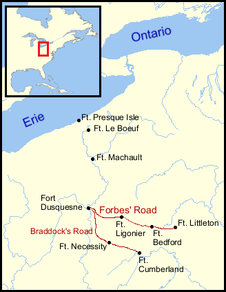
English: French and British forts built in the Ohio Country from 1753 to 1758. Includes French Forts (New France): Fort Presque Isle, Fort Le Boeuf, Fort Machault and Fort Duquesne. Also, British Forts: Fort Littleton, Fort Bedford, Fort Ligonier, Fort Necessity and Fort Cumberland. Shows positions of Lancaster, Pennsylvania, and Philadelphia, Pennsylvania. Also shows the approximate routes of Braddock's Road and Forbes Road. |
| Date | |
| Source | Positions determined by descriptions found in The Frontier Forts of Western Pennsylvania, Albert, George Dallas, C. M. Busch, state printer, Harrisburg, 1896, and other sources; Background map courtesy of Demis |
| Auteur | Thomas Cool |
| Autres versions |
Œuvres dérivées de ce fichier : |
Conditions d’utilisation
[modifier]
| Moi, propriétaire des droits d’auteur sur cette œuvre, la place dans le domaine public. Ceci s'applique dans le monde entier. Dans certains pays, ceci peut ne pas être possible ; dans ce cas : J’accorde à toute personne le droit d’utiliser cette œuvre dans n’importe quel but, sans aucune condition, sauf celles requises par la loi. |
This image is in the public domain because it came from the site https://www.demis.nl/products/web-map-server/examples/ and was released by the copyright holder. Permission is granted to copy, distribute and/or modify this map since it is based on free of copyright images from: www.demis.nl. See also approval email on de.wp and its clarification.
|
| This work has been released into the public domain by its copyright holder, www.demis.nl. This applies worldwide. Dans certains pays, ceci peut ne pas être possible ; dans ce cas : www.demis.nl accorde à toute personne le droit d’utiliser cette œuvre dans n’importe quel but, sans aucune condition, sauf celles requises par la loi.
|
Historique du fichier
Cliquer sur une date et heure pour voir le fichier tel qu'il était à ce moment-là.
| Date et heure | Vignette | Dimensions | Utilisateur | Commentaire | |
|---|---|---|---|---|---|
| actuel | 7 janvier 2007 à 21:46 | | 328 × 423 (32 kio) | Tomcool~commonswiki (d | contributions) | |
| 7 janvier 2007 à 21:31 |  | 328 × 423 (32 kio) | Tomcool~commonswiki (d | contributions) | ||
| 7 janvier 2007 à 21:27 |  | 328 × 423 (31 kio) | Tomcool~commonswiki (d | contributions) | ||
| 2 janvier 2007 à 23:27 |  | 328 × 423 (31 kio) | Tomcool~commonswiki (d | contributions) | ||
| 27 décembre 2006 à 02:24 |  | 328 × 423 (29 kio) | Tomcool~commonswiki (d | contributions) | ||
| 27 décembre 2006 à 02:22 |  | 328 × 423 (20 kio) | Tomcool~commonswiki (d | contributions) | ||
| 27 décembre 2006 à 02:07 |  | 328 × 423 (28 kio) | Tomcool~commonswiki (d | contributions) | ||
| 27 décembre 2006 à 01:57 |  | 328 × 423 (24 kio) | Tomcool~commonswiki (d | contributions) | ||
| 27 décembre 2006 à 01:10 |  | 715 × 762 (71 kio) | Tomcool~commonswiki (d | contributions) | ||
| 25 mars 2006 à 16:03 |  | 813 × 549 (719 kio) | Tomcool~commonswiki (d | contributions) | ==Description== French and British forts built in the Ohio Country from 1753 to 1758. Includes French Forts (New France): Fort Presque Isle, Fort Le Boeuf, Fort Machault and Fort Duquesne. Also, Britsh Forts: Fort Littleton, Fort Bedford, Fort Ligonier, |
Vous ne pouvez pas remplacer ce fichier.
Utilisations locales du fichier
Les 2 pages suivantes utilisent ce fichier :
Utilisations du fichier sur d’autres wikis
Les autres wikis suivants utilisent ce fichier :
- Utilisation sur ca.wikipedia.org
- Utilisation sur de.wikipedia.org
- Utilisation sur en.wikipedia.org
- Utilisation sur es.wikipedia.org
- Utilisation sur fr.wikipedia.org
- Utilisation sur he.wikipedia.org
- Utilisation sur it.wikipedia.org
- Utilisation sur ja.wikipedia.org
- Utilisation sur pt.wikipedia.org
Catégories :
- Maps of the French and Indian War
- Forts in Pennsylvania
- Forbes Road
- Braddock Road (Braddock expedition)
- Forbes Expedition
- Braddock Expedition
- 1750s maps of Pennsylvania
- French forts in the United States
- British forts in the United States
- Fort Le Boeuf
- Fort Machault
- Fort Presque Isle
- Fort Duquesne
- Fort Cumberland (Maryland)
- Maps of the history of Pennsylvania
- Maps of the history of Maryland
- Fort Lyttleton (Pennsylvania)