File:French Empire (1812).svg
Siirry navigaatioon
Siirry hakuun

Tämän PNG-esikatselun koko koskien SVG-tiedostoa: 450 × 456 kuvapistettä. Muut resoluutiot: 237 × 240 kuvapistettä | 474 × 480 kuvapistettä | 758 × 768 kuvapistettä | 1 011 × 1 024 kuvapistettä | 2 021 × 2 048 kuvapistettä.
Alkuperäinen tiedosto (SVG-tiedosto; oletustarkkuus 450 × 456 kuvapistettä; tiedostokoko 632 KiB)
Kuvatekstit
Kuvatekstit
Lisää yhden rivin pituinen kuvaus tästä tiedostosta
Yhteenveto[muokkaa]


.svg)
.svg)
.svg)
.svg)
.svg)


.svg)
.svg)
.svg)


.png)
.png)


.svg)


.svg)

.svg)


.svg)
.svg)
.svg)
.svg)


.svg)
.png)


.svg)


.svg)
.svg)


.svg)


.svg)


.svg&action=edit§ion=1)
.svg)
.svg)
.svg)
.svg)
.svg)
.svg)
.svg)
_cropped.svg)
.svg)
.svg)
.svg)
.svg)
.svg)
.svg)
.svg)
.svg)
.svg)
.svg)
.svg)
.svg)
.svg)
.svg)
.svg)
.svg)
.svg)
.svg)
.svg)
.svg)
.svg)
.svg)
.svg)
.svg)
.svg)
.svg)
.svg)
.svg)
.svg)
.svg)
.svg)
.svg)
.svg)
.svg)
.svg)
.svg)
.svg)
.svg)
.svg)
.svg)
.svg)
.svg)
.svg)
.svg)
.svg)
Tiedoston historia
Päiväystä napsauttamalla näet, millainen tiedosto oli kyseisellä hetkellä.
| Päiväys | Pienoiskuva | Koko | Käyttäjä | Kommentti | |
|---|---|---|---|---|---|
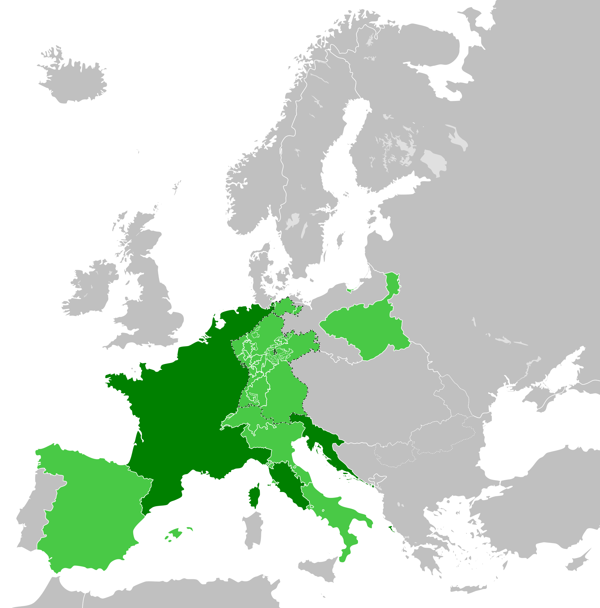
| nykyinen | 30. toukokuuta 2019 kello 22.32 | | 450 × 456 (632 KiB) | Cplakidas (keskustelu | muokkaukset) | correcting the Ionan Islands: they were not a client state, but annexed to France; and by 1812, most of them apart from Corfu and Paxoi (not depicted in this map) were under British control. |
| 5. tammikuuta 2018 kello 15.03 |  | 450 × 456 (611 KiB) | TRAJAN 117 (keskustelu | muokkaukset) | +++ | |
| 27. joulukuuta 2017 kello 11.52 |  | 450 × 456 (610 KiB) | TRAJAN 117 (keskustelu | muokkaukset) | +++ | |
| 24. joulukuuta 2017 kello 07.45 |  | 450 × 456 (610 KiB) | TRAJAN 117 (keskustelu | muokkaukset) | +++ | |
| 24. joulukuuta 2017 kello 01.59 |  | 450 × 456 (610 KiB) | TRAJAN 117 (keskustelu | muokkaukset) | Update | |
| 12. joulukuuta 2013 kello 07.49 |  | 450 × 456 (588 KiB) | TRAJAN 117 (keskustelu | muokkaukset) | Coloured in Ionian Islands. | |
| 5. lokakuuta 2013 kello 16.07 |  | 450 × 456 (588 KiB) | TRAJAN 117 (keskustelu | muokkaukset) | Updated | |
| 14. toukokuuta 2013 kello 01.42 |  | 450 × 456 (449 KiB) | TRAJAN 117 (keskustelu | muokkaukset) | Minor fix | |
| 14. toukokuuta 2013 kello 01.38 |  | 450 × 456 (449 KiB) | TRAJAN 117 (keskustelu | muokkaukset) | {{Information |Description ={{en|1=The French Empire in 1812.}} |Source ={{own}} {{AttribSVG|First French Empire 1812.svg|Alphathon}} |Author =TRAJAN 117 {{created with Inkscape}} |Date =2013-05-14 |Perm... |
Et voi tallentaa uutta tiedostoa tämän tilalle.
Tiedoston käyttö
Enemmän kuin 100 sivua linkittävät tähän tiedostoon. Seuraava lista näyttää 100 ensimmäistä sivua, jotka käyttävät vain tätä tiedostoa. Koko lista on saatavilla.
.svg)
- User:Alphathon/Historical Europe
- File:Albania 1956-1990.svg
- File:Albanian Kingdom (1935).svg
- File:Albanian Kingdom (1939).svg
- File:Austrian Lombardy 1789.svg
- File:Austrian Netherlands 1789.svg
- File:Austro-Hungarian Monarchy (1914).svg
- File:Blank map of Europe 1812.svg
- File:Blank map of Europe 1890.svg
- File:Blank map of Europe 1914.svg
- File:Blank map of Europe 1929-1938.svg
- File:Blank map of Europe 1956-1990.svg
- File:Blank map of Europe October 1938 - March 1939.svg
- File:Bulgaria 1956-1990.svg
- File:Confederation of the Rhine (1812).svg
- File:Cortina di ferro.png
- File:Czechoslovak Republic (1938).svg
- File:Czechoslovak Republic (1939).svg
- File:Czechoslovakia 1956–1990.svg
- File:Duchy of Holstein 1789.svg
- File:Duchy of Mecklenburg-Schwerin 1789.svg
- File:Duchy of Warsaw (1812).svg
- File:Duchy of Württemberg 1789.svg
- File:East Germany 1956-1990.svg
- File:Ecclesiastical lands of the Holy Roman Empire 1789.svg
- File:Electorate of Bavaria 1789.svg
- File:Electorate of Brunswick-Lüneburg 1789.svg
- File:Electorate of Saxony 1789.svg
- File:Europe 1789.svg
- File:Europe 1942.svg
- File:First French Empire 1812.svg
- File:Free City Danzig 1930.svg
- File:Free City of Danzig (1812).svg
- File:French Empire (1812).svg
- File:French State (1942).svg
- File:General Government (1942).svg
- File:German Empire 1914.svg
- File:German Reich (1939).svg
- File:Grand Duchy of Tuscany 1789.svg
- File:Grand Principality of Finland (1914).svg
- File:Greater German Reich (1942).svg
- File:Habsburg Monarchy 1789.svg
- File:Hellenic Republic (1935).svg
- File:Hungary 1956-1990.svg
- File:Imperial Italy.png
- File:InterwarCentralEurope.png
- File:Kingdom of Bulgaria (1914).svg
- File:Kingdom of France (1789).svg
- File:Kingdom of Greece (1890).svg
- File:Kingdom of Greece (1914).svg
- File:Kingdom of Greece (1973).svg
- File:Kingdom of Hungary (1942).svg
- File:Kingdom of Italy (1936).svg
- File:Kingdom of Italy (Napoleonic).svg
- File:Kingdom of Montenegro (1914).svg
- File:Kingdom of Portugal (1890).svg
- File:Kingdom of Prussia 1789.svg
- File:Kingdom of Romania (1890).svg
- File:Kingdom of Romania (1914).svg
- File:Kingdom of Romania (1939).svg
- File:Kingdom of Sardinia 1789.svg
- File:Kingdom of Serbia (1890).svg
- File:Kingdom of Serbia (1914).svg
- File:Kingdom of Spain (1789).svg
- File:Landgraviate of Hesse-Kassel 1789.svg
- File:Location Moldavian Democratic Republic.png
- File:Map Holy Roman Empire 1789.svg
- File:Map of the Republic of Serbia (2006–2008).svg
- File:Maps of Yugoslavia and FR Yugoslavia.svg
- File:Military Administration in Belgium and Northern France (1942).svg
- File:Military Administration in France (1942).svg
- File:Papal States 1789.svg
- File:Poland 1930.svg
- File:Poland 1956-1990.svg
- File:Polish-Lithuanian Commonwealth 1789.svg
- File:Prince-Bishopric of Montenegro (1812).svg
- File:Principality of Albania (1914).svg
- File:Principality of Bulgaria (1890).svg
- File:Principality of Montenegro (1890).svg
- File:Protectorate of Bohemia and Moravia (1942).svg
- File:Reichskommissariat Niederlande (1942).svg
- File:Reichskommissariat Norwegen (1942).svg
- File:Reichskommissariat Ostland (1942).svg
- File:Reichskommissariat Ukraine (1942).svg
- File:Republic of Genoa 1789.svg
- File:Republic of Montenegro (2006).svg
- File:Republic of Venice 1789.svg
- File:Republic of the Seven United Netherlands (1789).svg
- File:Romania 1956-1990.svg
- File:Serbia 1942.svg
- File:Slovak Republic (1942).svg
- File:Spanish Republic (1936).svg
- File:Spanish State (1975).svg
- File:Sweden 1789.svg
- File:Territory of the Serbian Uprising (1812).svg
- File:Voivodeship of Moldavia (1812).svg
- File:Voivodeship of Wallachia (1812).svg
- File:Weimar Republic 1930.svg
- File:West Germany 1956-1990.svg
- File:Yugoslavia 1956-1990.svg
.svg)
.svg)
.svg)
.svg)
Näytä lisää linkkejä tähän tiedostoon.
Tiedoston järjestelmänlaajuinen käyttö
Seuraavat muut wikit käyttävät tätä tiedostoa:
- Käyttö kohteessa als.wikipedia.org
- Käyttö kohteessa arc.wikipedia.org
- Käyttö kohteessa ar.wikipedia.org
- Käyttö kohteessa arz.wikipedia.org
- Käyttö kohteessa ast.wikipedia.org
- Käyttö kohteessa az.wikipedia.org
- Käyttö kohteessa cs.wikipedia.org
- Käyttö kohteessa de.wikipedia.org
- Käyttö kohteessa en.wikipedia.org
- Käyttö kohteessa en.wikibooks.org
- Käyttö kohteessa es.wikipedia.org
- Käyttö kohteessa fa.wikipedia.org
- Käyttö kohteessa fi.wikipedia.org
- Käyttö kohteessa gl.wikipedia.org
- Käyttö kohteessa hy.wikipedia.org
- Käyttö kohteessa id.wikipedia.org
- Käyttö kohteessa it.wikipedia.org
- Käyttö kohteessa ja.wikipedia.org
- Käyttö kohteessa ka.wikipedia.org
- Käyttö kohteessa ko.wikipedia.org
- Käyttö kohteessa la.wikipedia.org
- Käyttö kohteessa mt.wikipedia.org
- Käyttö kohteessa no.wikipedia.org
- Käyttö kohteessa pl.wikipedia.org
- Käyttö kohteessa pt.wikipedia.org
- Käyttö kohteessa ro.wikipedia.org
- Käyttö kohteessa ru.wikibooks.org
- Käyttö kohteessa sh.wikipedia.org
- Käyttö kohteessa simple.wikipedia.org
- Käyttö kohteessa tr.wikipedia.org
- Käyttö kohteessa vi.wikipedia.org
- Käyttö kohteessa www.wikidata.org
.svg&oldid=804374806)