File:French Mandate for Syria and the Lebanon map en.svg
Salta a la navegació
Salta a la cerca

Mida d'aquesta previsualització PNG del fitxer SVG: 725 × 599 píxels. Altres resolucions: 290 × 240 píxels | 581 × 480 píxels | 929 × 768 píxels | 1.239 × 1.024 píxels | 2.478 × 2.048 píxels | 922 × 762 píxels.
Fitxer original (fitxer SVG, nominalment 922 × 762 píxels, mida del fitxer: 245 Ko)
Llegendes
Llegendes
Afegeix una explicació d'una línia del que representa aquest fitxer
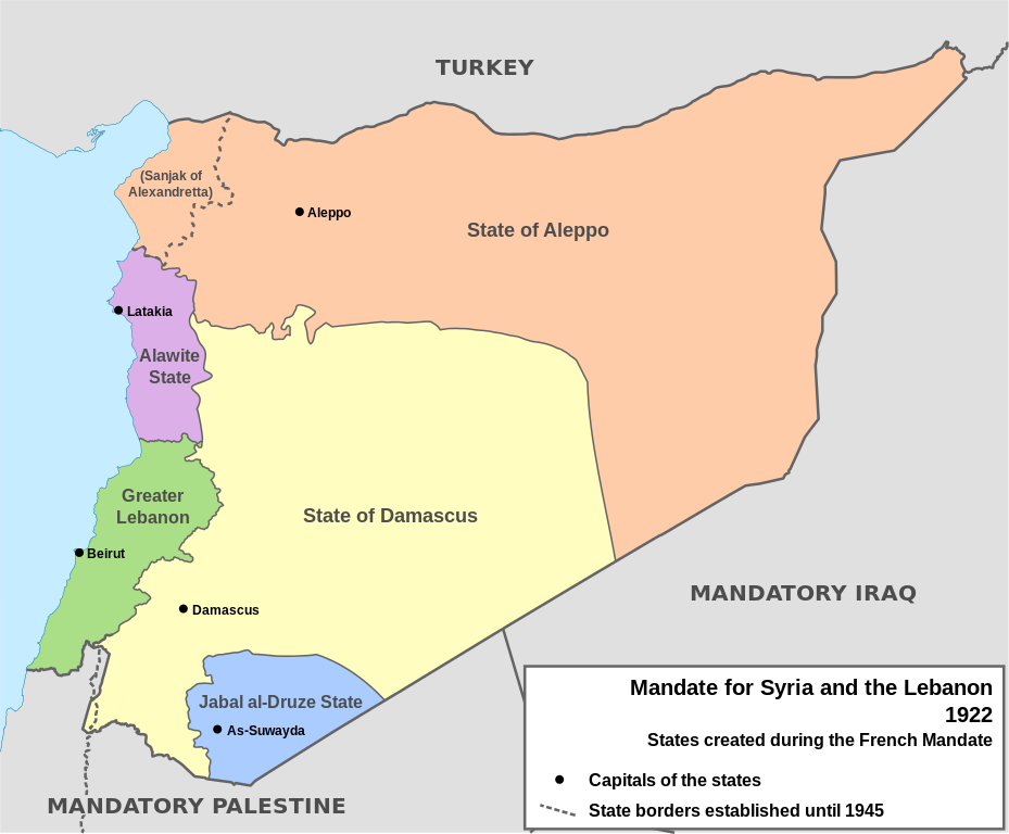
Map of the French Mandate for Syria and the Lebanon and the states created in 1922
Resum
[modifica]| Descripció |
English: Map of French Mandate for Syria and the Lebanon and the states created in 1922, in English. Sources:
|
| Data | |
| Font | Treball propi, based on File:Syria, administrative divisions - de - colored.svg |
| Autor | Don-kun, TUBS, NordNordWest |
| Altres versions |
[]
|


Llicència
[modifica]
Jo, el titular dels drets d'autor d'aquest treball, el public sota les següents llicències:

|
S'autoritza la còpia, la distribució i la modificació d'aquest document sota els termes de la llicència de documentació lliure GNU versió 1.2 o qualsevol altra versió posterior que publiqui la Free Software Foundation; sense seccions invariants, ni textos de portada, ni textos de contraportada. S'inclou una còpia d'aquesta llicència en la secció titulada GNU Free Documentation License. |
Aquest fitxer està subjecte a la llicència de Creative Commons Reconeixement 3.0 No adaptada.
- Sou lliure de:
- compartir – copiar, distribuir i comunicar públicament l'obra
- adaptar – fer-ne obres derivades
- Amb les condicions següents:
- reconeixement – Heu de donar la informació adequada sobre l'autor, proporcionar un enllaç a la llicència i indicar si s'han realitzat canvis. Podeu fer-ho amb qualsevol mitjà raonable, però de cap manera no suggereixi que l'autor us dóna suport o aprova l'ús que en feu.
Podeu seleccionar la llicència que vulgueu.
Historial del fitxer
Cliqueu una data/hora per veure el fitxer tal com era aleshores.
| Data/hora | Miniatura | Dimensions | Usuari/a | Comentari | |
|---|---|---|---|---|---|
| actual | 16:05, 4 feb 2013 | | 922 × 762 (245 Ko) | AnonMoos (discussió | contribucions) | Change "Libanon" to "Lebanon" |
| 15:33, 4 feb 2013 |  | 922 × 762 (250 Ko) | Don-kun (discussió | contribucions) | fix border to palestine, source: http://en.wikisource.org/wiki/Franco-British_Convention_on_Certain_Points_Connected_with_the_Mandates_for_Syria_and_the_Lebanon,_Palestine_and_Mesopotamia | |
| 18:43, 30 gen 2013 |  | 922 × 762 (248 Ko) | Don-kun (discussió | contribucions) | minus ahistorical lakes (and so all waterbodies) | |
| 21:44, 26 gen 2013 |  | 922 × 762 (282 Ko) | Don-kun (discussió | contribucions) | {{Information |Description ={{en|1=Map of French Mandate for Syria and the Lebanon and the states created in 1922, in English.}} |Source ={{own}}, based on File:Syria, administrative divisions - de - colored.svg |Author =[[User:... |
No podeu sobreescriure aquest fitxer.
Ús del fitxer
Les 17 pàgines següents utilitzen aquest fitxer:
- File:Flag-map of Syria (Irredentist).svg
- File:French Mandate for Syria and the Lebanon map ar.svg
- File:French Mandate for Syria and the Lebanon map ca.svg
- File:French Mandate for Syria and the Lebanon map de.svg
- File:French Mandate for Syria and the Lebanon map en.svg
- File:French Mandate for Syria and the Lebanon map es.svg
- File:French Mandate for Syria and the Lebanon map fr.svg
- File:French Mandate for Syria and the Lebanon map he.svg
- File:French Mandate for Syria and the Lebanon map hy.png
- File:French Mandate for Syria and the Lebanon map tr.svg
- Template:Other versions/French Mandate for Syria and the Lebanon
- Category:Alawite State
- Category:Djebel Druze State
- Category:French Mandate of Lebanon
- Category:Hatay State
- Category:State of Damascus
- Category:State of Greater Lebanon
.svg)
Ús global del fitxer
Utilització d'aquest fitxer en altres wikis:
- Utilització a af.wikipedia.org
- Utilització a ar.wikipedia.org
- Utilització a ast.wikipedia.org
- Utilització a azb.wikipedia.org
- Utilització a az.wikipedia.org
- Utilització a be.wikipedia.org
- Utilització a bg.wikipedia.org
- Utilització a bn.wikipedia.org
- Utilització a cs.wikipedia.org
- Utilització a de.wikipedia.org
- Utilització a el.wikipedia.org
- Utilització a en.wikipedia.org
Vegeu més usos globals d'aquest fitxer.