File:French Mandate for Syria and the Lebanon map en.svg
来自Wikimedia Commons
跳转到导航
跳转到搜索

此SVG文件的PNG预览的大小:725 × 599像素。 其他分辨率:290 × 240像素 | 581 × 480像素 | 929 × 768像素 | 1,239 × 1,024像素 | 2,478 × 2,048像素 | 922 × 762像素。
原始文件 (SVG文件,尺寸为922 × 762像素,文件大小:245 KB)
文件信息
结构化数据
说明
说明
添加一行文字以描述该文件所表现的内容
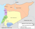
Map of the French Mandate for Syria and the Lebanon and the states created in 1922
Carte du mandat français en Syrie et au Liban et de ses états créés en 1922, en anglais
摘要
[编辑]| 描述French Mandate for Syria and the Lebanon map en.svg |
English: Map of French Mandate for Syria and the Lebanon and the states created in 1922, in English. Sources:
|
| 日期 | |
| 来源 | 自己的作品, based on File:Syria, administrative divisions - de - colored.svg |
| 作者 | Don-kun, TUBS, NordNordWest |
| 其他版本 |
[编辑]
|
许可协议
[编辑]我,本作品著作权人,特此采用以下许可协议发表本作品:

|
已授权您依据自由软件基金会发行的无固定段落及封面封底文字(Invariant Sections, Front-Cover Texts, and Back-Cover Texts)的GNU自由文件许可协议1.2版或任意后续版本的条款,复制、传播和/或修改本文件。该协议的副本请见“GNU Free Documentation License”。http://www.gnu.org/copyleft/fdl.htmlGFDLGNU Free Documentation Licensetruetrue |
本文件采用知识共享署名 3.0 未本地化版本许可协议授权。
- 您可以自由地:
- 共享 – 复制、发行并传播本作品
- 修改 – 改编作品
- 惟须遵守下列条件:
- 署名 – 您必须对作品进行署名,提供授权条款的链接,并说明是否对原始内容进行了更改。您可以用任何合理的方式来署名,但不得以任何方式表明许可人认可您或您的使用。
您可以选择您需要的许可协议。
文件历史
点击某个日期/时间查看对应时刻的文件。
| 日期/时间 | 缩略图 | 大小 | 用户 | 备注 | |
|---|---|---|---|---|---|
| 当前 | 2013年2月4日 (一) 16:05 |  | 922 × 762(245 KB) | AnonMoos(留言 | 贡献) | Change "Libanon" to "Lebanon" |
| 2013年2月4日 (一) 15:33 |  | 922 × 762(250 KB) | Don-kun(留言 | 贡献) | fix border to palestine, source: http://en.wikisource.org/wiki/Franco-British_Convention_on_Certain_Points_Connected_with_the_Mandates_for_Syria_and_the_Lebanon,_Palestine_and_Mesopotamia | |
| 2013年1月30日 (三) 18:43 |  | 922 × 762(248 KB) | Don-kun(留言 | 贡献) | minus ahistorical lakes (and so all waterbodies) | |
| 2013年1月26日 (六) 21:44 |  | 922 × 762(282 KB) | Don-kun(留言 | 贡献) | {{Information |Description ={{en|1=Map of French Mandate for Syria and the Lebanon and the states created in 1922, in English.}} |Source ={{own}}, based on File:Syria, administrative divisions - de - colored.svg |Author =[[User:... |
您不可以覆盖此文件。
文件用途
以下17个页面使用本文件:
- File:Flag-map of Syria (Irredentist).svg
- File:French Mandate for Syria and the Lebanon map ar.svg
- File:French Mandate for Syria and the Lebanon map ca.svg
- File:French Mandate for Syria and the Lebanon map de.svg
- File:French Mandate for Syria and the Lebanon map en.svg
- File:French Mandate for Syria and the Lebanon map es.svg
- File:French Mandate for Syria and the Lebanon map fr.svg
- File:French Mandate for Syria and the Lebanon map he.svg
- File:French Mandate for Syria and the Lebanon map hy.png
- File:French Mandate for Syria and the Lebanon map tr.svg
- Template:Other versions/French Mandate for Syria and the Lebanon
- Category:Alawite State
- Category:Djebel Druze State
- Category:French Mandate of Lebanon
- Category:Hatay State
- Category:State of Damascus
- Category:State of Greater Lebanon
全域文件用途
以下其他wiki使用此文件:
- af.wikipedia.org上的用途
- ar.wikipedia.org上的用途
- ast.wikipedia.org上的用途
- azb.wikipedia.org上的用途
- az.wikipedia.org上的用途
- be-tarask.wikipedia.org上的用途
- be.wikipedia.org上的用途
- bg.wikipedia.org上的用途
- bn.wikipedia.org上的用途
- cs.wikipedia.org上的用途
- de.wikipedia.org上的用途
- el.wikipedia.org上的用途
- en.wikipedia.org上的用途
查看此文件的更多全域用途。
元数据
此文件含有额外信息,这些信息可能是创建或数字化该文件时使用的数码相机或扫描仪所添加的。如果文件已从其原始状态修改,某些详细信息可能无法完全反映修改后的文件。
| 宽度 | 921.83398 |
|---|---|
| 高度 | 761.91602 |


