File:French Proposal 4 April 1946.jpg
跳至導覽
跳至搜尋
預覽大小:457 × 599 像素。 其他解析度:183 × 240 像素 | 366 × 480 像素 | 641 × 840 像素。
原始檔案 (641 × 840 像素,檔案大小:124 KB,MIME 類型:image/jpeg)
說明
說明
添加單行說明來描述出檔案所代表的內容
摘要[編輯]
| 描述 |
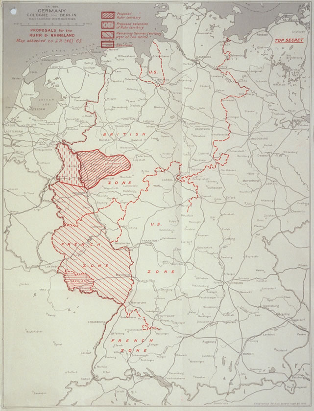
English: French Proposal for the Ruhr Area and the Rhineland. 日本語: ルール地域とラインラントに関するフランスの提案を示した地図。英国が作成。 |
| 日期 | |
| 來源 | http://zis.uibk.ac.at:81/zisneu/dokumente/karten/4.php |
| 作者 | The UK Chiefs of Staff Committee |
授權條款[編輯]
這一創作於英國管轄區內的作品現在位於公有領域。
其原因是以下之一:
HMSO已經宣布,皇家版權到期適用於全世界範圍(參考:HMSO Email Reply)
|
 |
原始上傳日誌[編輯]
The original description page was here. All following user names refer to en.wikipedia.
- 2008-07-06 14:34 Stor stark7 641×840× (126817 bytes) {{Information |Description= French Proposal for the Ruhr Area and the Rhineland. |Source=http://zis.uibk.ac.at:81/zisneu/dokumente/karten/4.php |Date=4.4.1946 |Author=The UK Chiefs of Staff Committee |Permission= UK crown copyright (which is what applies
檔案歷史
點選日期/時間以檢視該時間的檔案版本。
| 日期/時間 | 縮圖 | 尺寸 | 使用者 | 備註 | |
|---|---|---|---|---|---|
| 目前 | 2011年8月28日 (日) 09:39 | | 641 × 840(124 KB) | Lombroso(留言 | 貢獻) |
無法覆蓋此檔案。
檔案用途
沒有使用此檔案的頁面。
全域檔案使用狀況
以下其他 wiki 使用了這個檔案:
- ar.wikipedia.org 的使用狀況
- ca.wikipedia.org 的使用狀況
- de.wikipedia.org 的使用狀況
- es.wikipedia.org 的使用狀況
- et.wikipedia.org 的使用狀況
- fr.wikipedia.org 的使用狀況
- Plan Monnet
- Discussion:Plan Monnet
- Wikipédia:Statistiques des anecdotes de la page d'accueil/Visibilité des anecdotes (2017)
- Wikipédia:Le saviez-vous ?/Anecdotes proposées/Archivage des discussions/Archives/2017-1
- Wikipédia:Statistiques des anecdotes de la page d'accueil/Visibilité des anecdotes (2017)/2017 03
- Wikipédia:Le saviez-vous ?/Archives/2017
- it.wikipedia.org 的使用狀況
- ja.wikipedia.org 的使用狀況
- no.wikipedia.org 的使用狀況
- vi.wikipedia.org 的使用狀況
- zh.wikipedia.org 的使用狀況