File:French vineyards de.svg
Jump to navigation
Jump to search

Size of this PNG preview of this SVG file: 599 × 599 pixels. Other resolutions: 240 × 240 pixels | 480 × 480 pixels | 768 × 768 pixels | 1,023 × 1,024 pixels | 2,047 × 2,048 pixels | 1,796 × 1,797 pixels.
Original file (SVG file, nominally 1,796 × 1,797 pixels, file size: 385 KB)
Captions
Captions
Add a one-line explanation of what this file represents
| Description |
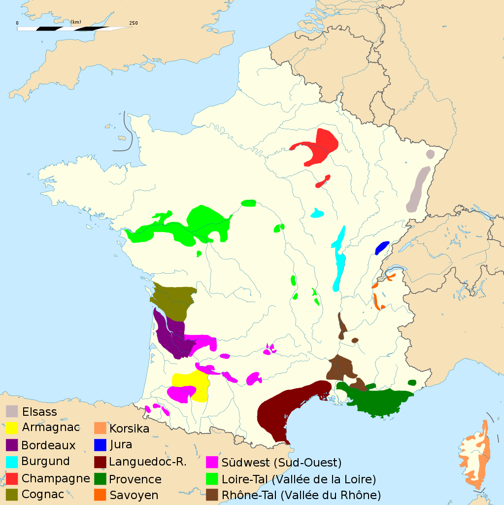
Deutsch: Karte der Weinbauregionen Frankreichs. English: Map of French vineyards. Français : Carte des principaux vignobles français. Español: Regiones vitivinícolas de Francia. |
| Date | (UTC) |
| Source | |
| Author |
|
| This is a retouched picture, which means that it has been digitally altered from its original version. Modifications: Deutsche Übersetzung/traduction allemand/German translation. The original can be viewed here: French vineyards.svg:
|
I, the copyright holder of this work, hereby publish it under the following license:
This file is licensed under the Creative Commons Attribution-Share Alike 2.5 Generic license.
- You are free:
- to share – to copy, distribute and transmit the work
- to remix – to adapt the work
- Under the following conditions:
- attribution – You must give appropriate credit, provide a link to the license, and indicate if changes were made. You may do so in any reasonable manner, but not in any way that suggests the licensor endorses you or your use.
- share alike – If you remix, transform, or build upon the material, you must distribute your contributions under the same or compatible license as the original.
Original upload log
[edit]
This image is a derivative work of the following images:
- File:French_vineyards.svg licensed with Cc-by-sa-2.5
- 2009-05-17T18:09:59Z Sdaubert 1796x1797 (663958 Bytes) Change some colors, move scale.
- 2009-05-17T14:25:37Z Sdaubert 1796x1797 (663915 Bytes) Change some colors. "Vallée du Rhône" instead of "Rhône" in legend.
- 2009-05-17T14:21:59Z Sdaubert 1796x1797 (663915 Bytes) Change some colors. "Vallée du Rhône" instead of "Rhône" in legend.
- 2009-05-17T13:05:42Z Sdaubert 1796x1797 (663957 Bytes) Coordinates deleted. Spanish rivers deleted (to ease reading of legend)
- 2009-05-17T11:32:09Z Sdaubert 1796x1797 (739086 Bytes) {{Information |Description={{en|Map of French vineyards.}} {{fr|Carte des principaux vignobles français.}} |Source=*[[:File:France_blank.svg|]] |Date=2009-05-17 12:30 (UTC) |Author=*[[:File:France_blank.svg|]]: Eric Gaba ([[
Uploaded with derivativeFX
File history
Click on a date/time to view the file as it appeared at that time.
| Date/Time | Thumbnail | Dimensions | User | Comment | |
|---|---|---|---|---|---|
| current | 20:09, 17 May 2009 | | 1,796 × 1,797 (385 KB) | Furfur (talk | contribs) | {{Information |Description={{de|Karte der Weinbauregionen Frankreichs.}} {{en|Map of French vineyards.}} {{fr|Carte des principaux vignobles français.}} {{es|Regiones vitivinícolas de Francia.}} |Source=*File:French_vineyards.svg |Date=2009-05-17 |
You cannot overwrite this file.
File usage on Commons
There are no pages that use this file.
File usage on other wikis
The following other wikis use this file:
- Usage on de.wikipedia.org
- Usage on nl.wikipedia.org
- Usage on pfl.wikipedia.org