File:Fundy High & Low tide.jpg
Original file (540 × 720 pixels, file size: 126 KB, MIME type: image/jpeg)
Captions
Captions
Summary
[edit]
| Description |
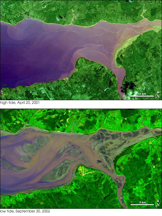
English: "This pair of images from the Advanced Spaceborne Thermal Emission and Reflection Radiometer (ASTER) on NASA’s Terra satellite shows the dramatic difference in the amount of water-covered land at the head of the southeast corner of the bay during a high tide on April 20, 2001, and a low tide on September 30, 2002. Vegetation is green, and water ranges from dark blue (deeper water) to light purple (shallow water)." |
| Date | |
| Source | NASA Earth Observatory, url=http://earthobservatory.nasa.gov/IOTD/view.php?id=6650 |
| Author | NASA/GSFC/METI/ERSDAC/JAROS, and U.S./Japan ASTER Science Team |
| Permission (Reusing this file) |
Images from NASA are usually free of copyright and are in the PUBLIC Domain. |
"The large tides in the Bay of Fundy result from tidal resonance. Tidal resonance occurs when the amount of time it takes a large wave to travel from the mouth of a bay to the far shore and back to the mouth is the same, or nearly the same, as the time between the high and low tides. This coincidence means that the general sloshing of the water around the bay can become synchronized with the lunar tides, amplifying their effect. When other factors come into play, such as storm surges, the tides in the Bay of Fundy have exceeded 20 meters."
Licensing
[edit]
| This file is in the public domain in the United States because it was solely created by NASA. NASA copyright policy states that "NASA material is not protected by copyright unless noted". (See Template:PD-USGov, NASA copyright policy page or JPL Image Use Policy.) | ||
 |
Warnings:
|
File history
Click on a date/time to view the file as it appeared at that time.
| Date/Time | Thumbnail | Dimensions | User | Comment | |
|---|---|---|---|---|---|
| current | 00:35, 28 May 2012 | | 540 × 720 (126 KB) | Marshallsumter (talk | contribs) | {{Information |Description ={{en|1="This pair of images from the Advanced Spaceborne Thermal Emission and Reflection Radiometer (ASTER) on NASA’s Terra satellite shows the dramatic difference in the amount of water-covered land at the head of the ... |
You cannot overwrite this file.
File usage on Commons
There are no pages that use this file.
File usage on other wikis
The following other wikis use this file:
- Usage on en.wikiversity.org