File:G-F triangulation.jpg
跳至導覽
跳至搜尋
無更高解析度可提供。
G-F_triangulation.jpg (272 × 400 像素,檔案大小:21 KB,MIME 類型:image/jpeg)
說明
說明
添加單行說明來描述出檔案所代表的內容
摘要[編輯]
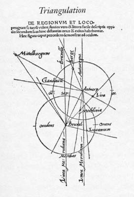
| 描述 | Gemma Frisius's 1533 diagram introducing the idea of triangulation into the science of surveying. Having established a baseline, eg the cities of Brussels and Antwerp, the location of other cities, eg Middelburg, can be found by taking its compass direction at each end of the baseline, and plotting where the two directions cross. Note that this was only a theoretical presentation of the concept -- because of hills etc, it is in fact actually impossible to see Middelburg from either Brussels or Antwerp! Nevertheless, the figure soon became well known all across Europe. |
| 日期 | |
| 來源 | Libellus de locorum describendorum ratione. This scan found at [1] |
| 作者 | Gemma Frisius |
![[1]](http://www.math.yorku.ca/SCS/Gallery/images/G-F_triangulation.jpg)
授權條款[編輯]
|
本作品在其來源國以及其他版權期限是作者逝世後100年或以下的國家與地區屬於公有領域。 | |
| 此作品無已知的著作權限制,亦不受所有相關和鄰接的權利限制。 | |
檔案歷史
點選日期/時間以檢視該時間的檔案版本。
| 日期/時間 | 縮圖 | 尺寸 | 用戶 | 備註 | |
|---|---|---|---|---|---|
| 目前 | 2008年4月30日 (三) 16:46 | | 272 × 400(21 KB) | Jheald(對話 | 貢獻) | {{Information |Description=en:Gemma Frisius's 1533 diagram introducing the idea of en:triangulation into the science of surveying. Having established a baseline, eg the cities of Brussels and Antwerp, the location of other cities, eg Middelberg |
無法覆蓋此檔案。
檔案用途
下列頁面有用到此檔案:
全域檔案使用狀況
以下其他 wiki 使用了這個檔案:
- de.wikipedia.org 的使用狀況
- de.wiktionary.org 的使用狀況
- en.wikipedia.org 的使用狀況
- eo.wikipedia.org 的使用狀況
- ja.wikipedia.org 的使用狀況
- pl.wikipedia.org 的使用狀況
- pl.wiktionary.org 的使用狀況
- ru.wikipedia.org 的使用狀況
- sl.wikipedia.org 的使用狀況
- zh.wikipedia.org 的使用狀況