File:Gafilo 2004-03-03.jpg
跳至導覽
跳至搜尋

預覽大小:600 × 600 像素。 其他解析度:240 × 240 像素 | 480 × 480 像素 | 768 × 768 像素 | 1,024 × 1,024 像素 | 2,048 × 2,048 像素 | 6,000 × 6,000 像素。
原始檔案 (6,000 × 6,000 像素,檔案大小:3.88 MB,MIME 類型:image/jpeg)
說明
說明
添加單行說明來描述出檔案所代表的內容
摘要
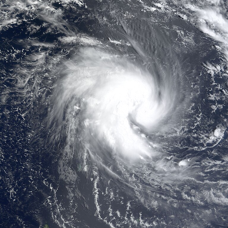
[編輯]| 描述 | The MODIS instrument onboard NASA's Terra satellite captured this true-color image of Tropical Cyclone Gafilo as it was churning in the Indian Ocean approximately 800 miles northwest of northern Madagascar. At the time this image was acquired, Gafilo had maximum sustained winds near 75 mph and was moving west at 8 mph. Gafilo was expected to strengthen and take a turn towards the southwest and possibly affect northern Madagascar by the weekend. | |||||
| 日期 | ||||||
| 來源 | http://earthobservatory.nasa.gov/NaturalHazards/natural_hazards_v2.php3?img_id=11984 | |||||
| 作者 | Image courtesy Jesse Allen, NASA Earth Observatory at NASA GSFC. | |||||
| 授權許可 (重用此檔案) |
|

檔案歷史
點選日期/時間以檢視該時間的檔案版本。
| 日期/時間 | 縮圖 | 尺寸 | 用戶 | 備註 | |
|---|---|---|---|---|---|
| 目前 | 2013年4月27日 (六) 12:10 | | 6,000 × 6,000(3.88 MB) | Meow(對話 | 貢獻) | Official size |
| 2006年11月16日 (四) 20:54 |  | 6,000 × 6,000(4.68 MB) | Good kitty(對話 | 貢獻) | == Summary == {{Information |Description=The MODIS instrument onboard NASA's Terra satellite captured this true-color image of Tropical Cyclone Gafilo as it was churning in the Indian Ocean approximately 800 miles northwest of northern Madagascar. At the |
無法覆蓋此檔案。
檔案用途
下列頁面有用到此檔案:
全域檔案使用狀況
以下其他 wiki 使用了這個檔案:
- en.wikipedia.org 的使用狀況
- fr.wikipedia.org 的使用狀況
- uk.wikipedia.org 的使用狀況
- zh.wikipedia.org 的使用狀況