File:Gains territoriaux de la France en 1814.svg
跳至導覽
跳至搜尋

此 SVG 檔案的 PNG 預覽的大小:632 × 600 像素。 其他解析度:253 × 240 像素 | 506 × 480 像素 | 809 × 768 像素 | 1,079 × 1,024 像素 | 2,158 × 2,048 像素 | 2,000 × 1,898 像素。
原始檔案 (SVG 檔案,表面大小:2,000 × 1,898 像素,檔案大小:314 KB)
說明
說明
添加單行說明來描述出檔案所代表的內容
摘要
[編輯]
| 描述 |
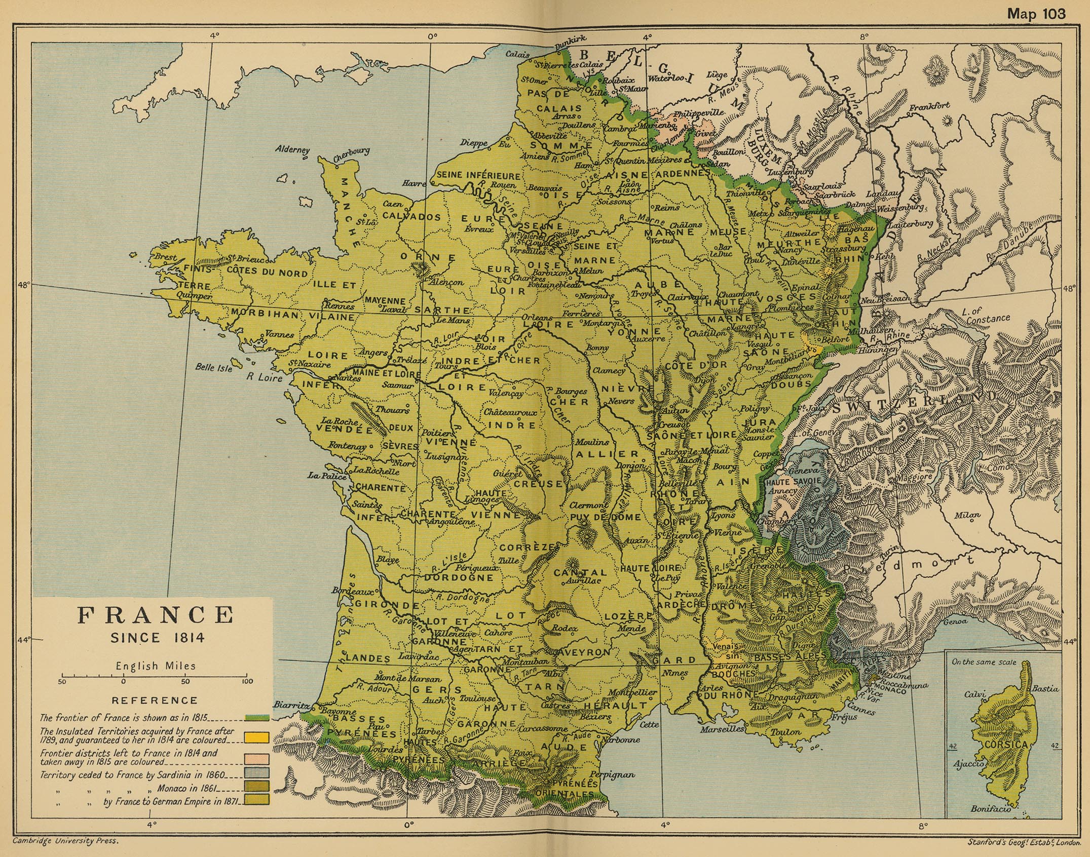
English: Blank map of France in 1814, with territories obtained with the 1814 Treaty of Paris (in red), but lost with the 1815 Treaty of Paris.
Français : Carte vierge de la France en 1814, avec en rouge les territoires obtenus par le Traité de Paris de 1814, mais perdus après le Traité de Paris de 1815, après l'épisode des 100 jours. Lambert-93 projection ; RGF-93 datum Scale: 1:2,000,000 |
| 日期 | (UTC) |
| 來源 |
|
| 作者 |
|
| 其他版本 | |
| 姓名標示 (由许可协议要求) | © Sémhur / Wikimedia Commons / |
| SVG | W3C-validity not checked. |
| Graphic Lab |
| 拍攝地點 | | 位於此地的本圖片與其他圖片: OpenStreetMap |
|---|
授權條款
[編輯]
我,本作品的著作權持有者,決定用以下授權條款發佈本作品:
| 公共版權:本藝術作品是自由的,您可以依據自由藝術作品許可協議的條款傳播和/或修改本藝術作品。您可以在Copyleft Attitude網站或其他網站找到該許可協議的樣本。 |
This file is licensed under the Creative Commons Attribution-Share Alike Attribution-Share Alike 4.0 International, 3.0 Unported, 2.5 Generic, 2.0 Generic and 1.0 Generic license.
- 您可以自由:
- 分享 – 複製、發佈和傳播本作品
- 重新修改 – 創作演繹作品
- 惟需遵照下列條件:
- 姓名標示 – 您必須指名出正確的製作者,和提供授權條款的連結,以及表示是否有對內容上做出變更。您可以用任何合理的方式來行動,但不得以任何方式表明授權條款是對您許可或是由您所使用。
- 相同方式分享 – 如果您利用本素材進行再混合、轉換或創作,您必須基於如同原先的相同或兼容的條款,來分布您的貢獻成品。
您可以選擇您需要的授權條款。
原始上傳日誌
[編輯]
This image is a derivative work of the following images:
- File:France_map_Lambert-93_with_regions_and_departments-blank.svg licensed with Cc-by-sa-3.0,2.5,2.0,1.0, GFDL
- 2008-11-13T17:38:21Z Sting 2000x1898 (885358 Bytes) + boundary for Channel Islands
- 2008-10-01T04:50:15Z Sting 2000x1898 (883528 Bytes) == Summary == {{Location|46|15|00|N|02|06|00|E|scale:10000000}} {{Information |Description={{en|Blank map of [[:en:France|France]] in the official Lambert-93 projection, with regions and departments boundaries.}} {{fr|Carte
Uploaded with derivativeFX
檔案歷史
點選日期/時間以檢視該時間的檔案版本。
| 日期/時間 | 縮圖 | 尺寸 | 用戶 | 備註 | |
|---|---|---|---|---|---|
| 目前 | 2014年2月8日 (六) 17:40 | | 2,000 × 1,898(314 KB) | Sémhur(對話 | 貢獻) | == {{int:filedesc}} == {{Information |Description= {{en|Blank map of France in 1814, with territories obtained with the 1814 Treaty of Paris (in red), but lost with the 1815 Treaty of Paris. }} {{fr|Carte vierge de la [[:fr:France|Franc... |
無法覆蓋此檔案。
檔案用途
下列2個頁面有用到此檔案:
全域檔案使用狀況
以下其他 wiki 使用了這個檔案:
- ca.wikipedia.org 的使用狀況
- de.wikipedia.org 的使用狀況
- en.wikipedia.org 的使用狀況
- es.wikipedia.org 的使用狀況
- fr.wikipedia.org 的使用狀況
- hi.wikipedia.org 的使用狀況
- it.wikipedia.org 的使用狀況
- mk.wikipedia.org 的使用狀況
- nl.wikipedia.org 的使用狀況
- pnb.wikipedia.org 的使用狀況
- ro.wikipedia.org 的使用狀況
- ur.wikipedia.org 的使用狀況
- vi.wikipedia.org 的使用狀況
- zh.wikipedia.org 的使用狀況