File:Galapagos Islands topographic map-en.svg
跳转到导航
跳转到搜索

此SVG文件的PNG预览的大小:600 × 600像素。 其他分辨率:240 × 240像素 | 480 × 480像素 | 768 × 768像素 | 1,024 × 1,024像素 | 2,048 × 2,048像素 | 2,160 × 2,160像素。
原始文件 (SVG文件,尺寸为2,160 × 2,160像素,文件大小:2.62 MB)
说明
说明
添加一行文字以描述该文件所表现的内容
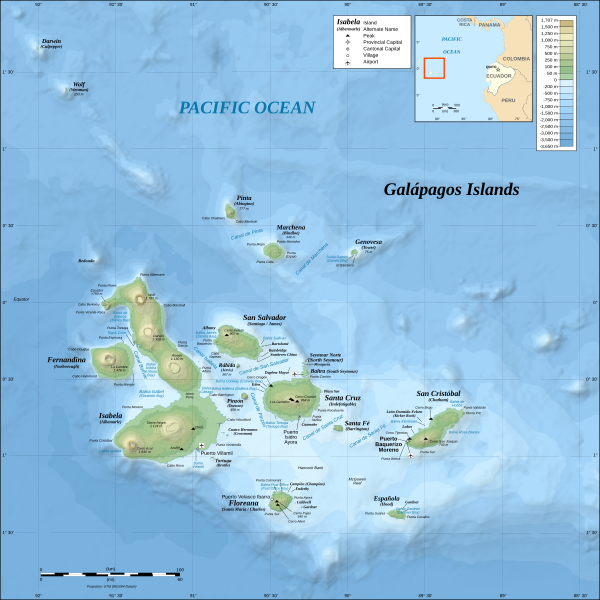
Topographic and bathymetric map of the Galápagos Islands, Ecuador.
摘要
[编辑]| 描述 |
*The background map is a raster image embedded in the SVG file. *UTM projection, WGS84 datum *Scales: **Topography: 1:800,000 (accuracy: 200m) **Bathymetry: 1:4,000,000 (accuracy: 1,000m) |
| 日期 | (UTC) |
| 来源 | |
| 作者 |
|
| 其他版本 |
[]
|

.png)


| 这是一张修改过的图片,这意味着它已在原版本的基础上通过软件进行了编辑,改动内容:Translated from German into English。其原始版本为:Galapagos Islands topographic map-de.svg。修改者:MatthewStevens。
|
我,本作品著作权人,特此采用以下许可协议发表本作品:
- 您可以自由地:
- 共享 – 复制、发行并传播本作品
- 修改 – 改编作品
- 惟须遵守下列条件:
- 署名 – 您必须对作品进行署名,提供授权条款的链接,并说明是否对原始内容进行了更改。您可以用任何合理的方式来署名,但不得以任何方式表明许可人认可您或您的使用。
- 相同方式共享 – 如果您再混合、转换或者基于本作品进行创作,您必须以与原先许可协议相同或相兼容的许可协议分发您贡献的作品。

|
已授权您依据自由软件基金会发行的无固定段落及封面封底文字(Invariant Sections, Front-Cover Texts, and Back-Cover Texts)的GNU自由文件许可协议1.2版或任意后续版本的条款,复制、传播和/或修改本文件。该协议的副本请见“GNU Free Documentation License”。 |
您可以选择您需要的许可协议。
原始上传日志
[编辑]
This image is a derivative work of the following images:
- File:Galapagos_Islands_topographic_map-de.svg licensed with Cc-by-sa-3.0,2.5,2.0,1.0, GFDL
- 2008-11-03T19:33:06Z NordNordWest 2160x2160 (2744048 Bytes) corrected
- 2008-10-26T17:07:45Z NordNordWest 2160x2160 (2746684 Bytes) {{Location|00|30|00|S|90|30|00|W|scale:1000000}} {{Information |Description= {{de|Topografische and bathymetrische Karte der [[:de:Galápagos-Inseln|Galápagos-Inseln]], [[:de:Ecuador|Ecuador]].}} {{en|Topographic and bathyme
Uploaded with derivativeFX
文件历史
点击某个日期/时间查看对应时刻的文件。
| 日期/时间 | 缩略图 | 大小 | 用户 | 备注 | |
|---|---|---|---|---|---|
| 当前 | 2016年10月4日 (二) 11:40 | | 2,160 × 2,160(2.62 MB) | Teofilo(留言 | 贡献) | <s>Marlborough</s> → Narborough |
| 2011年9月2日 (五) 00:15 |  | 2,160 × 2,160(2.62 MB) | MatthewStevens(留言 | 贡献) | {{Information |Description={{de|Topografische and bathymetrische Karte der Galápagos-Inseln, Ecuador.}} {{en|Topographic and bathymetric map of the Galápagos Islands, [[:en:Ecuador|Ecu |
您不可以覆盖此文件。
文件用途
以下11个页面使用本文件:
- Ecuador
- File:Galapagos Islands topographic map-blank.svg
- File:Galapagos Islands topographic map-blank (2).png
- File:Galapagos Islands topographic map-de.svg
- File:Galapagos Islands topographic map-en.svg
- File:Galapagos Islands topographic map-fi.svg
- File:Galapagos Islands topographic map-fr.png
- File:Galapagos Islands topographic map-fr.svg
- File:Galapagos Islands topographic map-mk.svg
- File:Galapagos Islands topographic map be.svg
- Template:Other versions/Galapagos Islands topographic map
全域文件用途
以下其他wiki使用此文件:
- azb.wikipedia.org上的用途
- bg.wikipedia.org上的用途
- br.wikipedia.org上的用途
- da.wikipedia.org上的用途
- en.wikipedia.org上的用途
- en.wikiversity.org上的用途
- es.wikipedia.org上的用途
- fa.wikipedia.org上的用途
- fy.wikipedia.org上的用途
- gl.wikipedia.org上的用途
- hy.wikipedia.org上的用途
- id.wikipedia.org上的用途
- is.wikipedia.org上的用途
- it.wikipedia.org上的用途
- km.wikipedia.org上的用途
- mi.wikipedia.org上的用途
- mr.wikipedia.org上的用途
- ms.wikipedia.org上的用途
- my.wikipedia.org上的用途
- nds-nl.wikipedia.org上的用途
- nl.wikipedia.org上的用途
- no.wikipedia.org上的用途
- pl.wikipedia.org上的用途
- pt.wikipedia.org上的用途
查看此文件的更多全域用途。
元数据
分类:
- Bathymetric maps of the Pacific Ocean
- Galapagos Rise
- Wolf-Darwin Lineament
- Topographic maps of the Galápagos Islands
- Mosquera Island
- Baltra
- Pinta Island
- Isla Marchena
- Maps of Genovesa Island
- Seymour Norte
- Daphne Mayor
- Cerro Dragon
- Enderby Island
- Lobos Island
- León Dormido
- Maps of Fernandina Island
- Maps of Isla Isabela (Galapagos)
- Maps of Santiago (Galápagos)
- Maps of Santa Cruz (Galápagos)
- Maps of Santa Fé (Barrington)
- Maps of Floreana Island
- Maps of Española Island (Galápagos)
- Wolf Island (Galápagos)
- Darwin Island
- Pinzón Island
- South Plaza
- Rábida Island
- Roca Redonda
- Los Gemelos (Santa Cruz, Galápagos)
- Chico volcano (Galápagos)