File:Ganges River Delta, Bangladesh, India.jpg

Archivo original (1400 × 1370 píxeles; tamaño de archivo: 805 kB; tipo MIME: image/jpeg)
Leyendas
Leyendas
Resumen
[editar]
| Descripción |
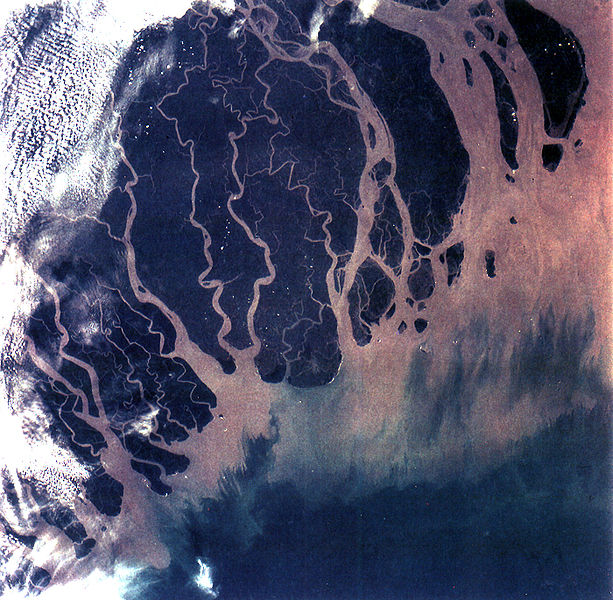
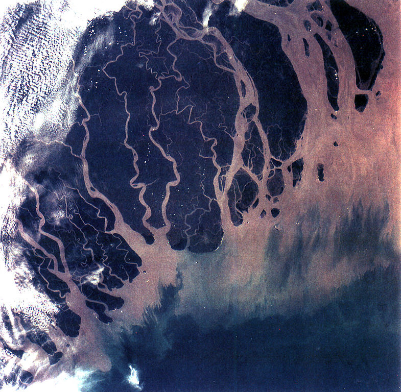
The Ganges River Delta (fig. 5) is the largest inter-tidal delta in the world. With its extensive mangrove mud flats, swamp vegetation and sand dunes, it is characteristic of many tropical and subtropical coasts. The vegetation cushions the shoreline from wind and wave action while the mangrove trees provide a habitat and food for aquatic and terrestrial plant and animal life. The increasing demand for lumber and firewood is outpacing the natural re-growth of the mangrove trees. Space Shuttle photographs, taken over time, permit monitoring of environmental changes in the delta caused by population pressures, and allows mapping of geological changes caused by shifting distributaries and delta growth. As seen in this photograph, the tributaries and distributaries of the Ganges and Brahmaputra Rivers deposit huge amounts of silt and clay that create a shifting maze of waterways and islands in the Bay of Bengal. |
| Fecha | |
| Fuente | https://eol.jsc.nasa.gov/SearchPhotos/photo.pl?mission=STS066&roll=92&frame=013 |
| Autor | NASA |
Este archivo fue catalogado por Johnson Space Center de la Administración Nacional de Aeronáutica y del Espacio (NASA) de los Estados Unidos de Américabajo el identificador de foto: STS066-92-013.Esta etiqueta no indica el estado de los derechos de autor del trabajo adjunto. Se requiere una etiqueta de derechos de autor normal. Para más información vea Commons:Sobre las licencias. Otros idiomas:
|
Licencia
[editar]
| Este archivo es de dominio público porque fue creado por la NASA. Las políticas sobre copyright de la NASA estipulan que «el material de la NASA no está protegido con copyright a menos que se indique lo contrario». (Políticas sobre copyright de la NASA o Políticas sobre la utilización de imágenes del Jet Propulsion Laboratory). | ||
 |
Advertencias:
|
Historial del archivo
Haz clic sobre una fecha y hora para ver el archivo tal como apareció en ese momento.
| Fecha y hora | Miniatura | Dimensiones | Usuario | Comentario | |
|---|---|---|---|---|---|
| actual | 20:07 25 oct 2005 | | 1400 × 1370 (805 kB) | Brian0918 (discusión | contribs.) | GANGES RIVER DELTA, BANGLADESH, INDIA (STS066-92-013). The Ganges River Delta (fig. 5) is the largest inter-tidal delta in the world. With its extensive mangrove mud flats, swamp vegetation and sand dunes, it is characteristic of many tropical and subtr |
No puedes sobrescribir este archivo.
Usos del archivo
Las siguientes páginas usan este archivo:
Uso global del archivo
Las wikis siguientes utilizan este archivo:
- Uso en ar.wikipedia.org
- Uso en ast.wikipedia.org
- Uso en bh.wikipedia.org
- Uso en bn.wikipedia.org
- Uso en br.wikipedia.org
- Uso en ca.wikipedia.org
- Uso en cs.wikipedia.org
- Uso en cy.wikipedia.org
- Uso en da.wikipedia.org
- Uso en en.wikipedia.org
- Geography of Bangladesh
- River delta
- Geography of West Bengal
- Water politics
- Geology of Bangladesh
- Ganges water dispute
- Portal:Geography/Featured picture/2009, week 39
- Portal:Geography/Featured picture archive/2009
- Outline of geography
- User:Bettymnz4/Geology of Bangladesh
- Flood pulse concept
- User talk:Vsmith/Archive27
- Deltaic lobe
- Uso en eo.wikipedia.org
- Uso en es.wikipedia.org
- Uso en et.wikipedia.org
- Uso en eu.wikipedia.org
- Uso en ext.wikipedia.org
- Uso en fr.wikipedia.org
- Uso en gl.wikipedia.org
- Uso en hif.wikipedia.org
- Uso en hi.wikipedia.org
Ver más uso global de este archivo.