File:Gaza Strip Access Restrictions.pdf

پروندهٔ اصلی (۴٬۹۵۰ × ۷٬۰۸۵ پیکسل، اندازهٔ پرونده: ۴٫۷۶ مگابایت، نوع MIME پرونده: application/pdf)
گزینهها
عنوان
خلاصه[ویرایش]
| توضیح |
Deutsch: Gazastreifen mit Zugangsbeschränkungen für seine Bewohner
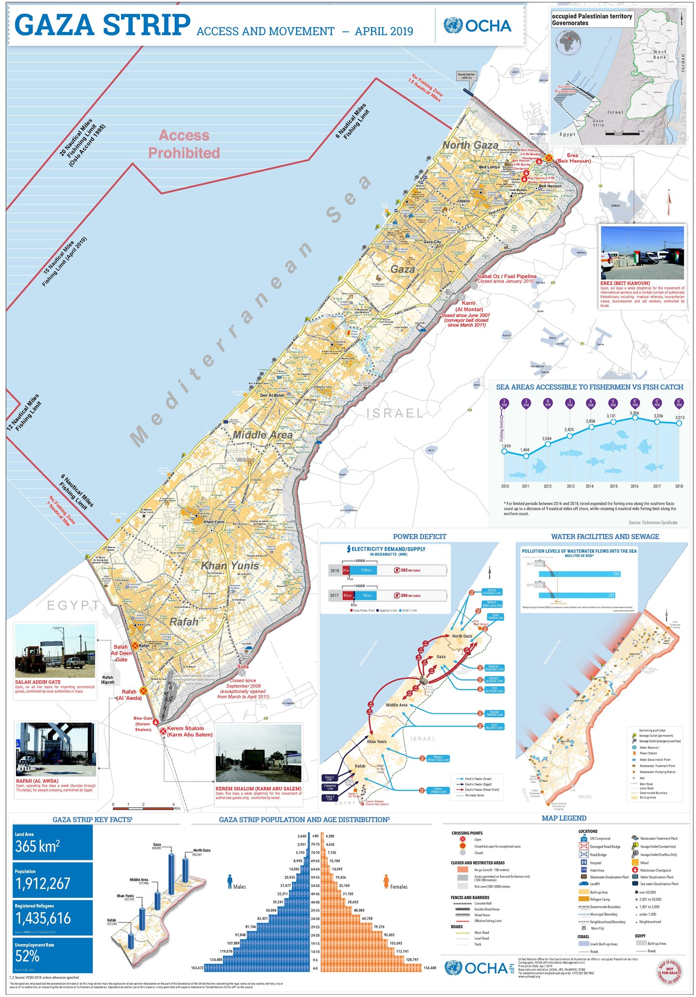
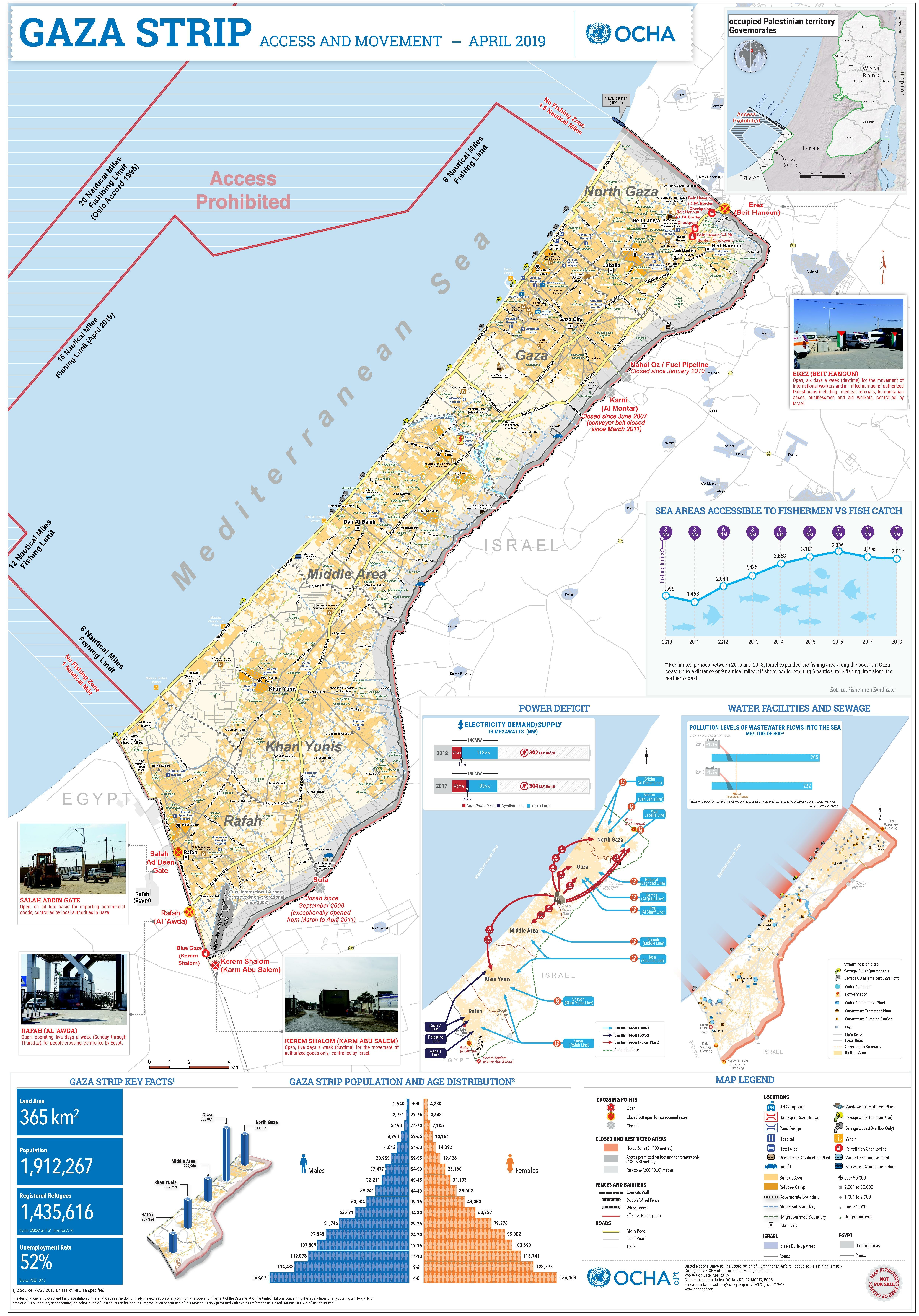
English: A map of the Gaza Strip and the access restrictions its residents have |
|||
| تاریخ | ||||
| منبع | https://www.ochaopt.org/sites/default/files/Gaza_A0_2023.pdf | |||
| پدیدآور | United Nations Office for the Coordination of Humanitarian Affairs (OCHA) | |||
| اجازهنامه (استفادهٔ مجدد از این پرونده) |
|

تاریخچهٔ پرونده
روی تاریخ/زمانها کلیک کنید تا نسخهٔ مربوط به آن هنگام را ببینید.
| تاریخ/زمان | بندانگشتی | ابعاد | کاربر | توضیح | |
|---|---|---|---|---|---|
| کنونی | ۱۲ دسامبر ۲۰۲۳، ساعت ۱۲:۱۳ |  | ۴٬۹۵۰ در ۷٬۰۸۵ (۴٫۷۶ مگابایت) | Wickey (بحث | مشارکتها) | Reverted to version as of 21:42, 14 December 2020 (UTC). Different image; please put it in a new file |
| ۸ اکتبر ۲۰۲۳، ساعت ۱۵:۲۷ |  | ۴٬۹۵۰ در ۷٬۰۸۵ (۶٫۸ مگابایت) | Isochrone (بحث | مشارکتها) | 2023 version from https://www.ochaopt.org/sites/default/files/Gaza_A0_2023.pdf | |
| ۱۴ دسامبر ۲۰۲۰، ساعت ۲۱:۴۲ |  | ۴٬۹۵۰ در ۷٬۰۸۵ (۴٫۷۶ مگابایت) | Veggies (بحث | مشارکتها) | {{Information |Description=A map of the Gaza Strip and the access restrictions its residents have |Source=https://www.ochaopt.org/sites/default/files/gaza_a0_press.pdf |Date=2019-05-07 |Author=United Nations Office for the Coordination of Humanitarian Affairs (OCHA) |Permission={{PD-UN-map}} |other_versions= }} |
شما نمیتوانید این پرونده را رونویسی کنید.
کاربرد پرونده
صفحهٔ زیر از این تصویر استفاده میکند:
کاربرد سراسری پرونده
ویکیهای دیگر زیر از این پرونده استفاده میکنند:
- کاربرد در ar.wikipedia.org
- کاربرد در arz.wikipedia.org
- کاربرد در az.wikipedia.org
- کاربرد در bn.wikipedia.org
- کاربرد در ca.wikipedia.org
- کاربرد در da.wikipedia.org
- کاربرد در de.wikipedia.org
- کاربرد در el.wikipedia.org
- کاربرد در en.wikipedia.org
- کاربرد در eo.wikipedia.org
- کاربرد در es.wikipedia.org
- کاربرد در eu.wikipedia.org
- کاربرد در fa.wikipedia.org
- کاربرد در fi.wikipedia.org
- کاربرد در fr.wikipedia.org
- کاربرد در he.wikipedia.org
- کاربرد در id.wikipedia.org
- کاربرد در ja.wikipedia.org
- کاربرد در kk.wikipedia.org
- کاربرد در ms.wikipedia.org
- کاربرد در nl.wikipedia.org
- کاربرد در no.wikipedia.org
- کاربرد در pap.wikipedia.org
- کاربرد در sat.wikipedia.org
- کاربرد در tr.wikipedia.org
- کاربرد در zh.wikipedia.org