File:Gaza Strip map2.svg
Salta a la navegació
Salta a la cerca

Mida d'aquesta previsualització PNG del fitxer SVG: 489 × 599 píxels. Altres resolucions: 196 × 240 píxels | 392 × 480 píxels | 627 × 768 píxels | 836 × 1.024 píxels | 1.672 × 2.048 píxels | 725 × 888 píxels.
Fitxer original (fitxer SVG, nominalment 725 × 888 píxels, mida del fitxer: 211 Ko)
Llegendes
Llegendes
Afegeix una explicació d'una línia del que representa aquest fitxer
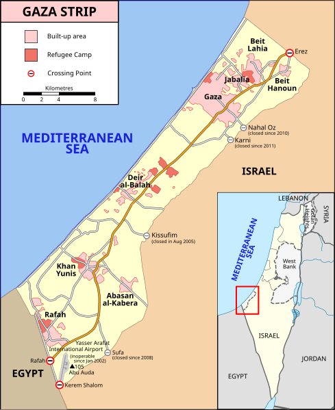
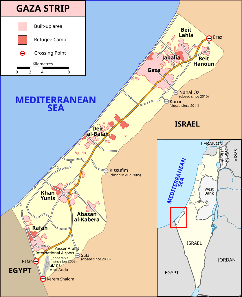
Location map of the Gaza Strip, showing built-up areas, refugee camps, and crossing points
Resum
[modifica]| Descripció |
[] Bahasa Indonesia: Peta Jalur Gaza menunjukkan kota-kota utama dan negara-negara tetangga. Deutsch: Gazastreifen, urspr. English: A map of the Gaza Strip showing key towns and neighbouring countries. Español: Mapa de la Franja de Gaza Français : Carte de la bande de Gaza Norsk bokmål: Kart over Gazastripen Türkçe: Gazze Şeridi haritası, önemli kentler ve komşu ülkeler gösteriliyor. Ελληνικά: Χάρτης της Λωρίδας της Γάζας με τις κύριες πόλεις και τις γειτονικές χώρες Кыргызча: Газа тилкесинин картасы 中文(繁體): 加沙地帶(或稱加薩走廊)地圖 العربية : خارطة قطاع غزة |
||
| Data | |||
| Font |
SVG version of File:Gaza_Strip_map.png, created using Inkscape v. 0.46. with help from GIMP 2.4.7.:
|
||
| Autor | Gringer (talk) 14:01, 8 January 2009 (UTC) | ||
| Altres versions |
[] Ver1:
Ver2:
|


Llicència
[modifica]
Aquest fitxer està subjecte a la llicència de Creative Commons Reconeixement i Compartir Igual 3.0 No adaptada.
- Sou lliure de:
- compartir – copiar, distribuir i comunicar públicament l'obra
- adaptar – fer-ne obres derivades
- Amb les condicions següents:
- reconeixement – Heu de donar la informació adequada sobre l'autor, proporcionar un enllaç a la llicència i indicar si s'han realitzat canvis. Podeu fer-ho amb qualsevol mitjà raonable, però de cap manera no suggereixi que l'autor us dóna suport o aprova l'ús que en feu.
- compartir igual – Si modifiqueu, transformeu, o generareu amb el material, haureu de distribuir les vostres contribucions sota una llicència similar o una de compatible com l'original
Historial del fitxer
Cliqueu una data/hora per veure el fitxer tal com era aleshores.
| Data/hora | Miniatura | Dimensions | Usuari/a | Comentari | |
|---|---|---|---|---|---|
| actual | 12:37, 20 feb 2024 | | 725 × 888 (211 Ko) | Artelow (discussió | contribucions) | File uploaded using svgtranslate tool (https://svgtranslate.toolforge.org/). Added translation for ky. |
| 11:05, 24 oct 2023 |  | 725 × 888 (210 Ko) | Artelow (discussió | contribucions) | File uploaded using svgtranslate tool (https://svgtranslate.toolforge.org/). Added translation for ky. | |
| 10:44, 24 oct 2023 |  | 725 × 888 (210 Ko) | Artelow (discussió | contribucions) | File uploaded using svgtranslate tool (https://svgtranslate.toolforge.org/). Added translation for ky. | |
| 20:27, 20 oct 2023 |  | 725 × 888 (194 Ko) | Davidpar (discussió | contribucions) | File uploaded using svgtranslate tool (https://svgtranslate.toolforge.org/). Added translation for ca. | |
| 15:21, 19 oct 2023 |  | 725 × 888 (176 Ko) | Guglani (discussió | contribucions) | File uploaded using svgtranslate tool (https://svgtranslate.toolforge.org/). Added translation for pa-guru. | |
| 09:55, 19 oct 2023 |  | 725 × 888 (176 Ko) | Guglani (discussió | contribucions) | File uploaded using svgtranslate tool (https://svgtranslate.toolforge.org/). Added translation for pa-guru. | |
| 08:38, 19 oct 2023 |  | 725 × 888 (176 Ko) | Guglani (discussió | contribucions) | File uploaded using svgtranslate tool (https://svgtranslate.toolforge.org/). Added translation for pa-guru. | |
| 23:24, 18 oct 2023 |  | 725 × 888 (158 Ko) | Ispanas (discussió | contribucions) | File uploaded using svgtranslate tool (https://svgtranslate.toolforge.org/). Added translation for lt. | |
| 05:23, 14 oct 2023 |  | 725 × 888 (140 Ko) | Gringer (discussió | contribucions) | Update text version per https://www.ochaopt.org/content/escalation-gaza-strip-and-israel-flash-update-1 | |
| 15:00, 8 oct 2023 |  | 725 × 888 (360 Ko) | Isochrone (discussió | contribucions) | Update closed border checkpoints per https://www.ochaopt.org/content/escalation-gaza-strip-and-israel-flash-update-1 |
No podeu sobreescriure aquest fitxer.
Ús del fitxer
Les 53 pàgines següents utilitzen aquest fitxer:
- Gaza
- User:Magog the Ogre/Multilingual legend/2023 October 13-16
- User:Magog the Ogre/Multilingual legend/2023 October 17-21
- User:Magog the Ogre/Multilingual legend/2023 October 22-26
- User:Magog the Ogre/Multilingual legend/2023 October 5-8
- User:Magog the Ogre/Multilingual legend/2024 February 20-24
- User talk:MapMaster
- File:Gaza Strip el.svg
- File:Gaza Strip map-hu.svg
- File:Gaza Strip map-ru.svg
- File:Gaza Strip map.png
- File:Gaza Strip map.svg
- File:Gaza Strip map2-ar1.svg
- File:Gaza Strip map2.svg
- File:Gaza Strip map2 heb.svg
- File:Gaza Strip map2 hr.svg
- File:Gaza Strip map2 id.svg
- File:Gaza Strip map2 ko.svg
- File:Gaza Strip map2 uk.svg
- File:Gaza Strip map2 zh1.svg
- File:Gaza Strip map - ITA.svg
- File:Gaza Strip map - fr.svg
- File:Gaza Strip map 2 polish version polska wersja pl.svg
- File:Gaza Strip map blank.svg
- File:Gaza Strip map el.svg
- File:Gaza Strip map fa.svg
- File:Gaza Strip map mk.svg
- File:Gaza Strip map sr.svg
- File:Gaza Strip ro.svg
- File:Gazastreifen Karte.png
- File:Gazastrook Nederlandstalige kaart.svg
- File:Gazeko zerrenda-eu.svg
- File:Gz-map-fr.png
- File:Gz-map-no.png
- File:Gz-map-tr.png
- File:Gz-map.png
- File:Gz-mapa.png
- File:Mapa De La Franja De Gaza-ca.svg
- File:Mapa da Faixa de Gaza.svg
- File:Mapa de la Franja de Gaza.svg
- File:Stráice Gaza learscail.svg
- File:مخيم رفح svg.jpg
- Template:Other versions/Gaza Strip map
- Help:Cartography
- Category:Border crossings of the Gaza Strip
- Category:Education in the Gaza Strip
- Category:Gaza Strip
- Category:Geography of the Gaza Strip
- Category:History of the Gaza Strip
- Category:March 2012 Gaza–Israel clashes
- Category:Mosques in the Gaza Strip
- Category:Populated places in the Gaza Strip
- Category:Villages in the Gaza Strip
Ús global del fitxer
Utilització d'aquest fitxer en altres wikis:
- Utilització a af.wikipedia.org
- Utilització a ang.wikipedia.org
- Utilització a ar.wikipedia.org
- Utilització a arz.wikipedia.org
- Utilització a ast.wikipedia.org
- Utilització a azb.wikipedia.org
- Utilització a az.wikipedia.org
- Utilització a ba.wikipedia.org
- Utilització a be-tarask.wikipedia.org
- Utilització a be.wikipedia.org
- Utilització a bg.wikipedia.org
- Utilització a bh.wikipedia.org
- Utilització a bn.wikipedia.org
- Utilització a ca.wikipedia.org
- Utilització a ce.wikipedia.org
- Utilització a cs.wikipedia.org
- Utilització a cs.wikiquote.org
- Utilització a cv.wikipedia.org
- Utilització a da.wikipedia.org
- Utilització a en.wikipedia.org
- Gaza Strip
- United Arab Republic
- Rafah
- Philadelphi Corridor
- Karni crossing
- 2006 Israeli operation in Beit Hanoun
- Fatah–Hamas conflict
- 2008 breach of the Egypt–Gaza border
- Blockade of the Gaza Strip
- Wikipedia:Graphics Lab/Map workshop/top
- Wikipedia:Graphics Lab/Map workshop
- Wikipedia:Graphics Lab/Resources/Map Advice
- Wikipedia:WikiProject Maps/Conventions/Historical maps
- 2009 Hamas political violence in Gaza
- File talk:Gaza Strip map2.svg
- Talk:Eastern Bloc/Archive 2
- Talk:United Nations Fact Finding Mission on the Gaza Conflict/Archive 2
- March 2010 Israel–Gaza clashes
- March 2012 Gaza–Israel clashes
Vegeu més usos globals d'aquest fitxer.