File:Gaza Strip map2.svg
Aller à la navigation
Aller à la recherche

Taille de cet aperçu PNG pour ce fichier SVG : 489 × 599 pixels. Autres résolutions : 196 × 240 pixels | 392 × 480 pixels | 627 × 768 pixels | 836 × 1 024 pixels | 1 672 × 2 048 pixels | 725 × 888 pixels.
Fichier d’origine (Fichier SVG, nominalement de 725 × 888 pixels, taille : 211 kio)
Légendes
Légendes
Ajoutez en une ligne la description de ce que représente ce fichier
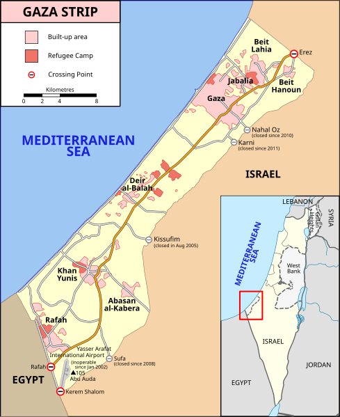
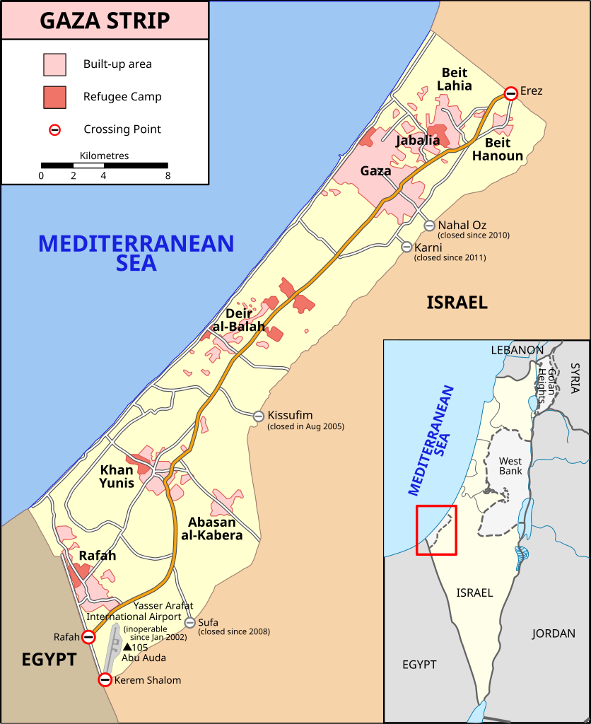
Location map of the Gaza Strip, showing built-up areas, refugee camps, and crossing points
Description
[modifier]| Description |
[] Bahasa Indonesia: Peta Jalur Gaza menunjukkan kota-kota utama dan negara-negara tetangga. Deutsch: Gazastreifen, urspr. English: A map of the Gaza Strip showing key towns and neighbouring countries. Español: Mapa de la Franja de Gaza Français : Carte de la bande de Gaza Norsk bokmål: Kart over Gazastripen Türkçe: Gazze Şeridi haritası, önemli kentler ve komşu ülkeler gösteriliyor. Ελληνικά: Χάρτης της Λωρίδας της Γάζας με τις κύριες πόλεις και τις γειτονικές χώρες Кыргызча: Газа тилкесинин картасы 中文(繁體): 加沙地帶(或稱加薩走廊)地圖 العربية : خارطة قطاع غزة |
||
| Date | |||
| Source |
SVG version of File:Gaza_Strip_map.png, created using Inkscape v. 0.46. with help from GIMP 2.4.7.:
|
||
| Auteur | Gringer (talk) 14:01, 8 January 2009 (UTC) | ||
| Autres versions |
[] Ver1:
Ver2:
|


Conditions d’utilisation
[modifier]
Ce fichier est disponible selon les termes de la licence Creative Commons Attribution – Partage dans les Mêmes Conditions 3.0 (non transposée).
- Vous êtes libre :
- de partager – de copier, distribuer et transmettre cette œuvre
- d’adapter – de modifier cette œuvre
- Sous les conditions suivantes :
- paternité – Vous devez donner les informations appropriées concernant l'auteur, fournir un lien vers la licence et indiquer si des modifications ont été faites. Vous pouvez faire cela par tout moyen raisonnable, mais en aucune façon suggérant que l’auteur vous soutient ou approuve l’utilisation que vous en faites.
- partage à l’identique – Si vous modifiez, transformez, ou vous basez sur cette œuvre, vous devez distribuer votre contribution sous la même licence ou une licence compatible avec celle de l’original.
Historique du fichier
Cliquer sur une date et heure pour voir le fichier tel qu'il était à ce moment-là.
| Date et heure | Vignette | Dimensions | Utilisateur | Commentaire | |
|---|---|---|---|---|---|
| actuel | 20 février 2024 à 12:37 | | 725 × 888 (211 kio) | Artelow (d | contributions) | File uploaded using svgtranslate tool (https://svgtranslate.toolforge.org/). Added translation for ky. |
| 24 octobre 2023 à 11:05 |  | 725 × 888 (210 kio) | Artelow (d | contributions) | File uploaded using svgtranslate tool (https://svgtranslate.toolforge.org/). Added translation for ky. | |
| 24 octobre 2023 à 10:44 |  | 725 × 888 (210 kio) | Artelow (d | contributions) | File uploaded using svgtranslate tool (https://svgtranslate.toolforge.org/). Added translation for ky. | |
| 20 octobre 2023 à 20:27 |  | 725 × 888 (194 kio) | Davidpar (d | contributions) | File uploaded using svgtranslate tool (https://svgtranslate.toolforge.org/). Added translation for ca. | |
| 19 octobre 2023 à 15:21 |  | 725 × 888 (176 kio) | Guglani (d | contributions) | File uploaded using svgtranslate tool (https://svgtranslate.toolforge.org/). Added translation for pa-guru. | |
| 19 octobre 2023 à 09:55 |  | 725 × 888 (176 kio) | Guglani (d | contributions) | File uploaded using svgtranslate tool (https://svgtranslate.toolforge.org/). Added translation for pa-guru. | |
| 19 octobre 2023 à 08:38 |  | 725 × 888 (176 kio) | Guglani (d | contributions) | File uploaded using svgtranslate tool (https://svgtranslate.toolforge.org/). Added translation for pa-guru. | |
| 18 octobre 2023 à 23:24 |  | 725 × 888 (158 kio) | Ispanas (d | contributions) | File uploaded using svgtranslate tool (https://svgtranslate.toolforge.org/). Added translation for lt. | |
| 14 octobre 2023 à 05:23 |  | 725 × 888 (140 kio) | Gringer (d | contributions) | Update text version per https://www.ochaopt.org/content/escalation-gaza-strip-and-israel-flash-update-1 | |
| 8 octobre 2023 à 15:00 |  | 725 × 888 (360 kio) | Isochrone (d | contributions) | Update closed border checkpoints per https://www.ochaopt.org/content/escalation-gaza-strip-and-israel-flash-update-1 |
Vous ne pouvez pas remplacer ce fichier.
Utilisations locales du fichier
Les 54 pages suivantes utilisent ce fichier :
- Gaza
- User:Magog the Ogre/Multilingual legend/2023 October 13-16
- User:Magog the Ogre/Multilingual legend/2023 October 17-21
- User:Magog the Ogre/Multilingual legend/2023 October 22-26
- User:Magog the Ogre/Multilingual legend/2023 October 5-8
- User:Magog the Ogre/Multilingual legend/2024 February 20-24
- User talk:MapMaster
- File:Gaza Strip el.svg
- File:Gaza Strip map-hu.svg
- File:Gaza Strip map-ru.svg
- File:Gaza Strip map.png
- File:Gaza Strip map.svg
- File:Gaza Strip map2-ar1.svg
- File:Gaza Strip map2.svg
- File:Gaza Strip map2 heb.svg
- File:Gaza Strip map2 hr.svg
- File:Gaza Strip map2 id.svg
- File:Gaza Strip map2 ko.svg
- File:Gaza Strip map2 uk.svg
- File:Gaza Strip map2 zh1.svg
- File:Gaza Strip map - ITA.svg
- File:Gaza Strip map - fr.svg
- File:Gaza Strip map 2 polish version polska wersja pl.svg
- File:Gaza Strip map ar.svg
- File:Gaza Strip map blank.svg
- File:Gaza Strip map el.svg
- File:Gaza Strip map fa.svg
- File:Gaza Strip map mk.svg
- File:Gaza Strip map sr.svg
- File:Gaza Strip ro.svg
- File:Gazastreifen Karte.png
- File:Gazastrook Nederlandstalige kaart.svg
- File:Gazeko zerrenda-eu.svg
- File:Gz-map-fr.png
- File:Gz-map-no.png
- File:Gz-map-tr.png
- File:Gz-map.png
- File:Gz-mapa.png
- File:Mapa De La Franja De Gaza-ca.svg
- File:Mapa da Faixa de Gaza.svg
- File:Mapa de la Franja de Gaza.svg
- File:Stráice Gaza learscail.svg
- File:مخيم رفح svg.jpg
- Template:Other versions/Gaza Strip map
- Help:Cartography
- Category:Border crossings of the Gaza Strip
- Category:Education in the Gaza Strip
- Category:Gaza Strip
- Category:Geography of the Gaza Strip
- Category:History of the Gaza Strip
- Category:March 2012 Gaza–Israel clashes
- Category:Mosques in the Gaza Strip
- Category:Populated places in the Gaza Strip
- Category:Villages in the Gaza Strip
Utilisations du fichier sur d’autres wikis
Les autres wikis suivants utilisent ce fichier :
- Utilisation sur af.wikipedia.org
- Utilisation sur ang.wikipedia.org
- Utilisation sur ar.wikipedia.org
- Utilisation sur arz.wikipedia.org
- Utilisation sur ast.wikipedia.org
- Utilisation sur azb.wikipedia.org
- Utilisation sur az.wikipedia.org
- Utilisation sur ba.wikipedia.org
- Utilisation sur be-tarask.wikipedia.org
- Utilisation sur be.wikipedia.org
- Utilisation sur bg.wikipedia.org
- Utilisation sur bh.wikipedia.org
- Utilisation sur bn.wikipedia.org
- Utilisation sur ca.wikipedia.org
- Utilisation sur ce.wikipedia.org
- Utilisation sur cs.wikipedia.org
- Utilisation sur cs.wikiquote.org
- Utilisation sur cv.wikipedia.org
- Utilisation sur da.wikipedia.org
- Utilisation sur en.wikipedia.org
- Gaza Strip
- United Arab Republic
- Rafah
- Philadelphi Corridor
- Karni crossing
- 2006 Israeli operation in Beit Hanoun
- Fatah–Hamas conflict
- 2008 breach of the Egypt–Gaza border
- Blockade of the Gaza Strip
- Wikipedia:Graphics Lab/Map workshop/top
- Wikipedia:Graphics Lab/Map workshop
- Wikipedia:Graphics Lab/Resources/Map Advice
- Wikipedia:WikiProject Maps/Conventions/Historical maps
- 2009 Hamas political violence in Gaza
- File talk:Gaza Strip map2.svg
- Talk:Eastern Bloc/Archive 2
- Talk:United Nations Fact Finding Mission on the Gaza Conflict/Archive 2
- March 2010 Israel–Gaza clashes
- March 2012 Gaza–Israel clashes
Voir davantage sur l’utilisation globale de ce fichier.