File:Gaza Strip map2.svg
跳至導覽
跳至搜尋

此 SVG 檔案的 PNG 預覽的大小:489 × 599 像素。 其他解析度:196 × 240 像素 | 392 × 480 像素 | 627 × 768 像素 | 836 × 1,024 像素 | 1,672 × 2,048 像素 | 725 × 888 像素。
原始檔案 (SVG 檔案,表面大小:725 × 888 像素,檔案大小:211 KB)
說明
說明
添加單行說明來描述出檔案所代表的內容
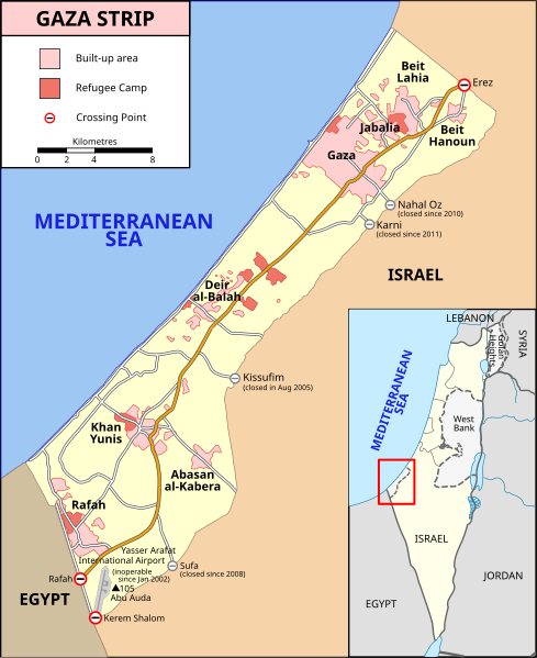
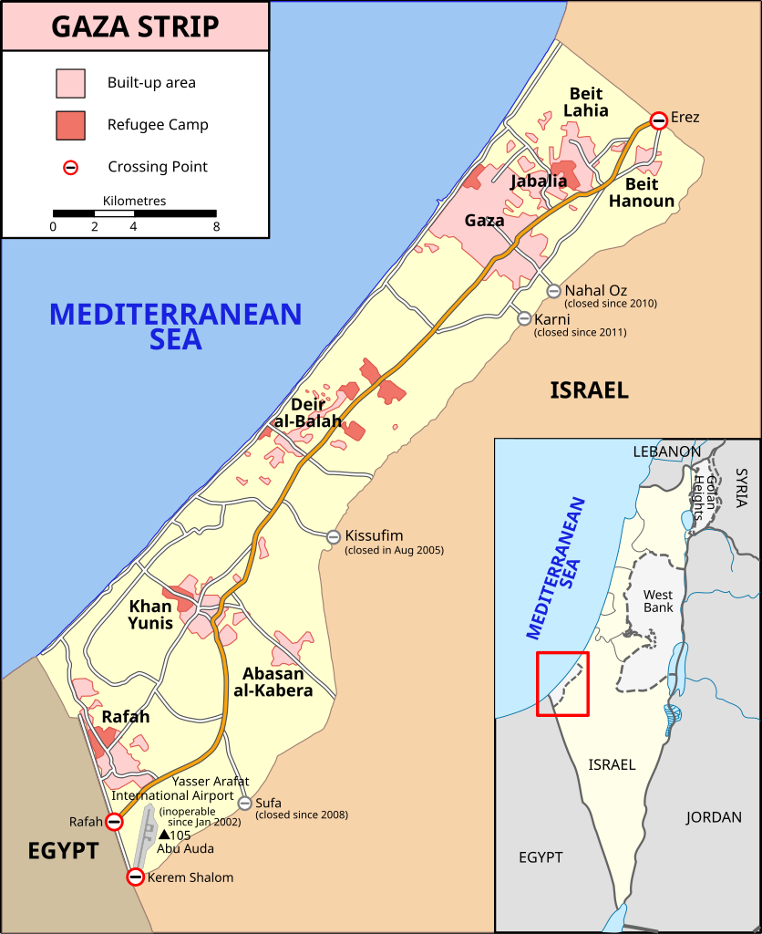
Location map of the Gaza Strip, showing built-up areas, refugee camps, and crossing points
摘要
[編輯]| 描述 |
[] Bahasa Indonesia: Peta Jalur Gaza menunjukkan kota-kota utama dan negara-negara tetangga. Deutsch: Gazastreifen, urspr. English: A map of the Gaza Strip showing key towns and neighbouring countries. Español: Mapa de la Franja de Gaza Français : Carte de la bande de Gaza Norsk bokmål: Kart over Gazastripen Türkçe: Gazze Şeridi haritası, önemli kentler ve komşu ülkeler gösteriliyor. Ελληνικά: Χάρτης της Λωρίδας της Γάζας με τις κύριες πόλεις και τις γειτονικές χώρες Кыргызча: Газа тилкесинин картасы 中文(繁體): 加沙地帶(或稱加薩走廊)地圖 العربية : خارطة قطاع غزة |
||
| 日期 | |||
| 來源 |
SVG version of File:Gaza_Strip_map.png, created using Inkscape v. 0.46. with help from GIMP 2.4.7.:
|
||
| 作者 | Gringer (talk) 14:01, 8 January 2009 (UTC) | ||
| 其他版本 |
[] Ver1:
Ver2:
|


授權條款
[編輯]
此檔案採用創用CC 姓名標示-相同方式分享 3.0 未在地化版本授權條款。
- 您可以自由:
- 分享 – 複製、發佈和傳播本作品
- 重新修改 – 創作演繹作品
- 惟需遵照下列條件:
- 姓名標示 – 您必須指名出正確的製作者,和提供授權條款的連結,以及表示是否有對內容上做出變更。您可以用任何合理的方式來行動,但不得以任何方式表明授權條款是對您許可或是由您所使用。
- 相同方式分享 – 如果您利用本素材進行再混合、轉換或創作,您必須基於如同原先的相同或兼容的條款,來分布您的貢獻成品。
檔案歷史
點選日期/時間以檢視該時間的檔案版本。
| 日期/時間 | 縮圖 | 尺寸 | 使用者 | 備註 | |
|---|---|---|---|---|---|
| 目前 | 2024年2月20日 (二) 12:37 | | 725 × 888(211 KB) | Artelow(留言 | 貢獻) | File uploaded using svgtranslate tool (https://svgtranslate.toolforge.org/). Added translation for ky. |
| 2023年10月24日 (二) 11:05 |  | 725 × 888(210 KB) | Artelow(留言 | 貢獻) | File uploaded using svgtranslate tool (https://svgtranslate.toolforge.org/). Added translation for ky. | |
| 2023年10月24日 (二) 10:44 |  | 725 × 888(210 KB) | Artelow(留言 | 貢獻) | File uploaded using svgtranslate tool (https://svgtranslate.toolforge.org/). Added translation for ky. | |
| 2023年10月20日 (五) 20:27 |  | 725 × 888(194 KB) | Davidpar(留言 | 貢獻) | File uploaded using svgtranslate tool (https://svgtranslate.toolforge.org/). Added translation for ca. | |
| 2023年10月19日 (四) 15:21 |  | 725 × 888(176 KB) | Guglani(留言 | 貢獻) | File uploaded using svgtranslate tool (https://svgtranslate.toolforge.org/). Added translation for pa-guru. | |
| 2023年10月19日 (四) 09:55 |  | 725 × 888(176 KB) | Guglani(留言 | 貢獻) | File uploaded using svgtranslate tool (https://svgtranslate.toolforge.org/). Added translation for pa-guru. | |
| 2023年10月19日 (四) 08:38 |  | 725 × 888(176 KB) | Guglani(留言 | 貢獻) | File uploaded using svgtranslate tool (https://svgtranslate.toolforge.org/). Added translation for pa-guru. | |
| 2023年10月18日 (三) 23:24 |  | 725 × 888(158 KB) | Ispanas(留言 | 貢獻) | File uploaded using svgtranslate tool (https://svgtranslate.toolforge.org/). Added translation for lt. | |
| 2023年10月14日 (六) 05:23 |  | 725 × 888(140 KB) | Gringer(留言 | 貢獻) | Update text version per https://www.ochaopt.org/content/escalation-gaza-strip-and-israel-flash-update-1 | |
| 2023年10月8日 (日) 15:00 |  | 725 × 888(360 KB) | Isochrone(留言 | 貢獻) | Update closed border checkpoints per https://www.ochaopt.org/content/escalation-gaza-strip-and-israel-flash-update-1 |
無法覆蓋此檔案。
檔案用途
下列55個頁面有用到此檔案:
- Gaza
- User:Magog the Ogre/Multilingual legend/2023 October 13-16
- User:Magog the Ogre/Multilingual legend/2023 October 17-21
- User:Magog the Ogre/Multilingual legend/2023 October 22-26
- User:Magog the Ogre/Multilingual legend/2023 October 5-8
- User:Magog the Ogre/Multilingual legend/2024 February 20-24
- User talk:MapMaster
- File:Gaza Strip el.svg
- File:Gaza Strip map-hu.svg
- File:Gaza Strip map-ru.svg
- File:Gaza Strip map.png
- File:Gaza Strip map.svg
- File:Gaza Strip map2-ar1.svg
- File:Gaza Strip map2.svg
- File:Gaza Strip map2 heb.svg
- File:Gaza Strip map2 hr.svg
- File:Gaza Strip map2 id.svg
- File:Gaza Strip map2 ko.svg
- File:Gaza Strip map2 uk.svg
- File:Gaza Strip map2 zh1.svg
- File:Gaza Strip map - ITA.svg
- File:Gaza Strip map - fr.svg
- File:Gaza Strip map 2 polish version polska wersja pl.svg
- File:Gaza Strip map ar.svg
- File:Gaza Strip map blank.svg
- File:Gaza Strip map el.svg
- File:Gaza Strip map fa.svg
- File:Gaza Strip map mk.svg
- File:Gaza Strip map sr.svg
- File:Gaza Strip ro.svg
- File:Gazastreifen Karte.png
- File:Gazastrook Nederlandstalige kaart.svg
- File:Gazeko zerrenda-eu.svg
- File:Gz-map-fr.png
- File:Gz-map-no.png
- File:Gz-map-tr.png
- File:Gz-map.png
- File:Gz-mapa.png
- File:Mapa De La Franja De Gaza-ca.svg
- File:Mapa da Faixa de Gaza.svg
- File:Mapa de la Franja de Gaza.svg
- File:Stráice Gaza learscail.svg
- File:مخيم رفح svg.jpg
- Template:Other versions/Gaza Strip map
- Help:Cartography
- Category:Archaeological sites in the Gaza Strip
- Category:Border crossings of the Gaza Strip
- Category:Education in the Gaza Strip
- Category:Gaza Strip
- Category:Geography of the Gaza Strip
- Category:History of the Gaza Strip
- Category:March 2012 Gaza–Israel clashes
- Category:Mosques in the Gaza Strip
- Category:Populated places in the Gaza Strip
- Category:Villages in the Gaza Strip
全域檔案使用狀況
以下其他 wiki 使用了這個檔案:
- af.wikipedia.org 的使用狀況
- ang.wikipedia.org 的使用狀況
- ar.wikipedia.org 的使用狀況
- arz.wikipedia.org 的使用狀況
- ast.wikipedia.org 的使用狀況
- azb.wikipedia.org 的使用狀況
- az.wikipedia.org 的使用狀況
- ba.wikipedia.org 的使用狀況
- be-tarask.wikipedia.org 的使用狀況
- be.wikipedia.org 的使用狀況
- bg.wikipedia.org 的使用狀況
- bh.wikipedia.org 的使用狀況
- bn.wikipedia.org 的使用狀況
- ca.wikipedia.org 的使用狀況
- ce.wikipedia.org 的使用狀況
- cs.wikipedia.org 的使用狀況
- cs.wikiquote.org 的使用狀況
- cv.wikipedia.org 的使用狀況
- da.wikipedia.org 的使用狀況
- en.wikipedia.org 的使用狀況
- Gaza Strip
- United Arab Republic
- Rafah
- Philadelphi Corridor
- Karni crossing
- 2006 Israeli operation in Beit Hanoun
- Fatah–Hamas conflict
- 2008 breach of the Egypt–Gaza border
- Blockade of the Gaza Strip
- Wikipedia:Graphics Lab/Map workshop/top
- Wikipedia:Graphics Lab/Map workshop
- Wikipedia:Graphics Lab/Resources/Map Advice
- Wikipedia:WikiProject Maps/Conventions/Historical maps
- 2009 Hamas political violence in Gaza
- File talk:Gaza Strip map2.svg
- Talk:Eastern Bloc/Archive 2
- Talk:United Nations Fact Finding Mission on the Gaza Conflict/Archive 2
- March 2010 Israel–Gaza clashes
- March 2012 Gaza–Israel clashes
檢視此檔案的更多全域使用狀況。