File:Gaza Strip map2 ko.svg
Jump to navigation
Jump to search

Size of this PNG preview of this SVG file: 489 × 599 pixels. Other resolutions: 196 × 240 pixels | 392 × 480 pixels | 627 × 768 pixels | 836 × 1,024 pixels | 1,672 × 2,048 pixels | 725 × 888 pixels.
Original file (SVG file, nominally 725 × 888 pixels, file size: 159 KB)
Captions
Captions
Add a one-line explanation of what this file represents
Summary[edit]
| Description |
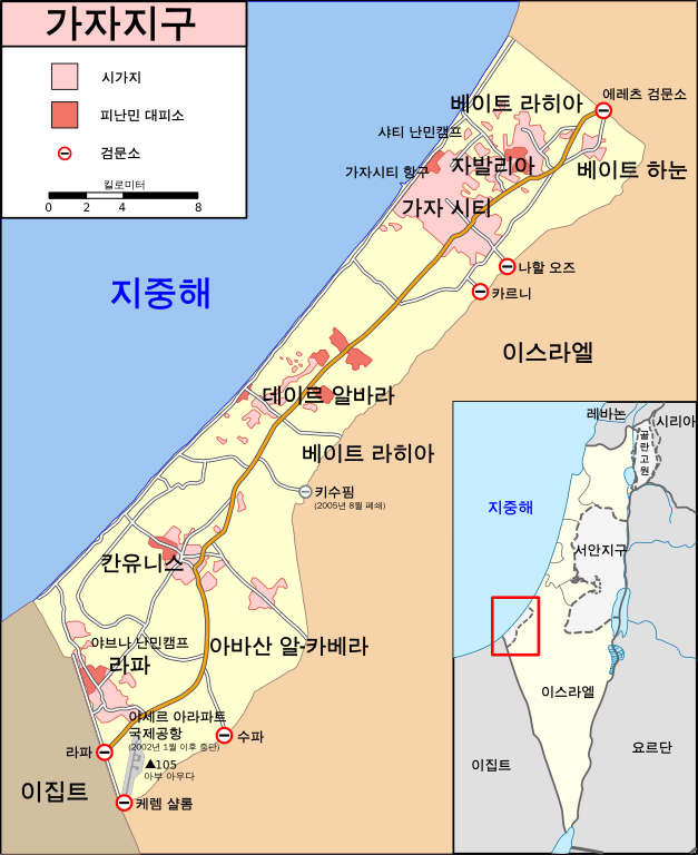
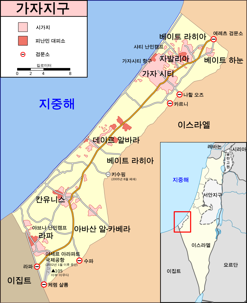
[] Bahasa Indonesia: Peta Jalur Gaza menunjukkan kota-kota utama dan negara-negara tetangga. Deutsch: Gazastreifen, urspr. English: A map of the Gaza Strip showing key towns and neighbouring countries. Español: Mapa de la Franja de Gaza Français : Carte de la bande de Gaza Norsk bokmål: Kart over Gazastripen Türkçe: Gazze Şeridi haritası, önemli kentler ve komşu ülkeler gösteriliyor. Ελληνικά: Χάρτης της Λωρίδας της Γάζας με τις κύριες πόλεις και τις γειτονικές χώρες Кыргызча: Газа тилкесинин картасы 中文(繁體): 加沙地帶(或稱加薩走廊)地圖 العربية : خارطة قطاع غزة |
| Date | |
| Source | en:File:Gaza Strip map2.svg |
| Author | Gringer translated by 102orion |
| Other versions |
[] Ver1:
Ver2:
|


Licensing[edit]
I, the copyright holder of this work, hereby publish it under the following license:
This file is licensed under the Creative Commons Attribution-Share Alike 3.0 Unported license.
- You are free:
- to share – to copy, distribute and transmit the work
- to remix – to adapt the work
- Under the following conditions:
- attribution – You must give appropriate credit, provide a link to the license, and indicate if changes were made. You may do so in any reasonable manner, but not in any way that suggests the licensor endorses you or your use.
- share alike – If you remix, transform, or build upon the material, you must distribute your contributions under the same or compatible license as the original.
File history
Click on a date/time to view the file as it appeared at that time.
| Date/Time | Thumbnail | Dimensions | User | Comment | |
|---|---|---|---|---|---|
| current | 17:00, 8 October 2023 | | 725 × 888 (159 KB) | LametinoWiki (talk | contribs) | File uploaded using svgtranslate tool (https://svgtranslate.toolforge.org/). Added translation for eu. |
| 11:59, 28 June 2010 |  | 725 × 888 (157 KB) | 102orion (talk | contribs) | Changed "골란고원"'s font direction from vertical to horizontal. | |
| 14:04, 27 June 2010 |  | 725 × 888 (157 KB) | 102orion (talk | contribs) | {{Information |Description={{en|1=Map of Gaza Strip, Stand December 2008 (SVG version of File:Gaza Strip map.png by Lencer)}} {{kr|가자지구(2008년 12월)}} |Source=SVG version of [[:File:Gaza_Strip_map.png] |
You cannot overwrite this file.
File usage on Commons
The following 71 pages use this file:
- User:Magog the Ogre/Multilingual legend/2023 October 5-8
- File:Gaza Strip el.svg
- File:Gaza Strip map-hu.svg
- File:Gaza Strip map-ru.svg
- File:Gaza Strip map.png
- File:Gaza Strip map.svg
- File:Gaza Strip map2-ar1.svg
- File:Gaza Strip map2.svg
- File:Gaza Strip map2 hr.svg
- File:Gaza Strip map2 id.svg
- File:Gaza Strip map2 ko.svg
- File:Gaza Strip map2 kr.svg (file redirect)
- File:Gz-map.png
- File:Gz-mapa.png
- File:Gazastreifen Karte.png
- File:Gz-map-fr.png
- File:Gaza Strip map.svg
- File:Gaza Strip map blank.svg
- File:Gz-map-no.png
- File:Gaza Strip map el.svg
- File:Gaza Strip map.png
- File:Gaza Strip map2.svg
- File:Mapa de la Franja de Gaza.svg
- File:Gazastrook Nederlandstalige kaart.svg
- File:Gaza Strip el.svg
- File:Gaza Strip map2-ar1.svg
- File:Gaza Strip ro.svg
- File:Mapa da Faixa de Gaza.svg
- File:Gaza Strip map fa.svg
- File:Gaza Strip map2 uk.svg
- File:Gaza Strip map 2 polish version polska wersja pl.svg
- File:Gaza Strip map - ITA.svg
- File:Gz-map-tr.png
- File:Gaza Strip map2 ko.svg
- File:Gaza Strip map mk.svg
- File:Stráice Gaza learscail.svg
- File:مخيم رفح svg.jpg
- File:Gaza Strip map sr.svg
- File:Gaza Strip map2 zh1.svg
- File:Gaza Strip map - fr.svg
- Template:Other versions/Gaza Strip map
- File:Gaza Strip map-hu.svg
- File:Gaza Strip map2 id.svg
- File:Mapa De La Franja De Gaza-ca.svg
- User:Magog the Ogre/Multilingual legend/2023 October 5-8
- File:Gaza Strip map-ru.svg
- File:Gaza Strip map2 hr.svg
- File:Gaza Strip map2 uk.svg
- File:Gaza Strip map2 zh1.svg
- File:Gaza Strip map - ITA.svg
- File:Gaza Strip map - fr.svg
- File:Gaza Strip map 2 polish version polska wersja pl.svg
- File:Gaza Strip map blank.svg
- File:Gaza Strip map el.svg
- File:Gaza Strip map fa.svg
- File:Gaza Strip map mk.svg
- File:Gaza Strip map sr.svg
- File:Gaza Strip ro.svg
- File:Gazastreifen Karte.png
- File:Gazastrook Nederlandstalige kaart.svg
- File:Gz-map-fr.png
- File:Gz-map-no.png
- File:Gz-map-tr.png
- File:Gz-map.png
- File:Gz-mapa.png
- File:Mapa De La Franja De Gaza-ca.svg
- File:Mapa da Faixa de Gaza.svg
- File:Mapa de la Franja de Gaza.svg
- File:Stráice Gaza learscail.svg
- File:مخيم رفح svg.jpg
- Template:Other versions/Gaza Strip map
File usage on other wikis
The following other wikis use this file:
- Usage on ko.wikipedia.org