File:Geiger, Alabama tornado damage.jpg
Jump to navigation
Jump to search
No higher resolution available.
Geiger,_Alabama_tornado_damage.jpg (640 × 480 pixels, file size: 75 KB, MIME type: image/jpeg)
Captions
Captions
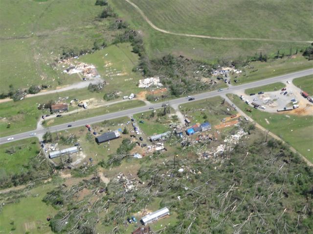
EF3 damage south of Geiger, Alabama.
Summary
[edit]
| Description |
English: EF3 damage south of Geiger, Alabama, including the destruction of a mobile home and a church. |
| Date | Taken on 16 April 2011 12:32:10 |
| Source | https://services.dat.noaa.gov/arcgis/rest/services/nws_damageassessmenttoolkit/DamageViewer/FeatureServer/0/30206/attachments/17334 |
| Author | NWS Birmingham |
| Camera location | | View this and other nearby images on: OpenStreetMap |
|---|
Licensing
[edit]
This file is in the public domain in the United States because it was solely created by employees of the National Weather Service or National Severe Storms Laboratory using the Damage Assessment Toolkit (DAT), an interactive map and database.
|
File history
Click on a date/time to view the file as it appeared at that time.
| Date/Time | Thumbnail | Dimensions | User | Comment | |
|---|---|---|---|---|---|
| current | 22:01, 30 March 2021 | | 640 × 480 (75 KB) | ChessEric (talk | contribs) | Uploaded a work by NWS Birmingham from https://services.dat.noaa.gov/arcgis/rest/services/nws_damageassessmenttoolkit/DamageViewer/FeatureServer/0/30206/attachments/17334 with UploadWizard |
You cannot overwrite this file.
File usage on Commons
The following page uses this file:
File usage on other wikis
The following other wikis use this file:
- Usage on en.wikipedia.org