File:Geiselhöring Schieglmühle Seidlmühle Kreuz.jpg
Original file (3,096 × 4,128 pixels, file size: 5.51 MB, MIME type: image/jpeg)
Captions
Captions
Summary
[edit]
| Description |
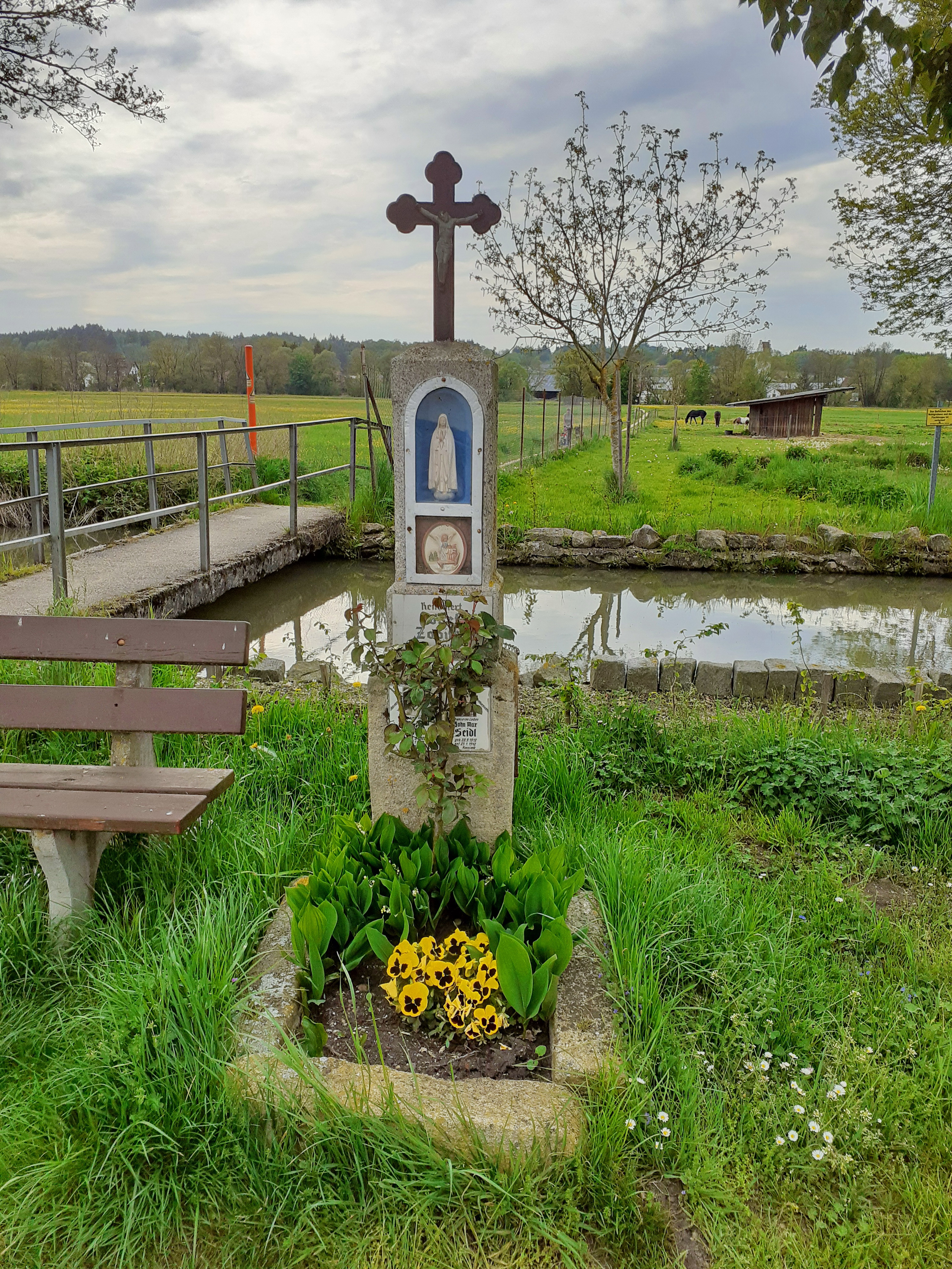
Deutsch: Zwischen Geiselhöring und Greißing befindet sich an der Laber die Schieglmühle oder auch Seidlmühle genannt. Von Geiselhöring führt eine Straße zu dem Einödhof. Ein schmaler Gangsteig verbindet diese beiden Orte auf kürzestem Weg. Die Mühle erzeugt wie weitere Mühlen an der Laber als Wasserkraftwerk elektrischen Strom. Direkt vor dem Stauwehr führt ein Steg über die Laber. Am Ufer steht eine schlanke Kreuzsäule hinter einem Blumenbeet mit Graniteinfassung. Daneben ist eine Ruhebank aufgestellt.
Auf einem Quaderstein befindet sich eingerückt ein Zwischenblock, auf dem der schlankere Stein mit Figurennische errichtet ist. Der oberste, abgeschrägte Stein ist mit einem gusseisernen Kreuz mit breiten Balken und Kleeblattenden bekrönt. An der Vorderseite ist ein konchenförmiger, verglaster Schrein mit blauem Hintergrund eingearbeitet in dem eine weißgekleidete Marienfigur mit gefalteten Händen im Stil der Fatima Madonna steht. Weiter unten befindet sich ein ovales Schutzengelbild. Ein Engel geleitet zwei Kinder sicher über einen Steg an einem Bach. Eine silberfarbene Einfassung aus breitem Flacheisen rahmt die beiden Bilder ein. Eine Tafel erinnert an die Renovierung des Kreuzes durch Josef Zapilko im Jahr 2003. Am Sockelstein sind Andenkentafeln der beiden Seidlsöhne angebracht, die im Zweiten Weltkrieg gefallen sind: Sohn Karl Seidl, geboren 02.08.1908 - gefallen 15.01.1944 in Russland Sohn Max Seidl, geboren 20.09.1913 - gefallen 25.01.1942 in Russland |
| Date | |
| Source | Own work |
| Author | Elcom.stadler |
| Camera location | | View this and other nearby images on: OpenStreetMap |
|---|
Licensing
[edit]
- You are free:
- to share – to copy, distribute and transmit the work
- to remix – to adapt the work
- Under the following conditions:
- attribution – You must give appropriate credit, provide a link to the license, and indicate if changes were made. You may do so in any reasonable manner, but not in any way that suggests the licensor endorses you or your use.
- share alike – If you remix, transform, or build upon the material, you must distribute your contributions under the same or compatible license as the original.
File history
Click on a date/time to view the file as it appeared at that time.
| Date/Time | Thumbnail | Dimensions | User | Comment | |
|---|---|---|---|---|---|
| current | 15:48, 7 February 2023 | | 3,096 × 4,128 (5.51 MB) | Elcom.stadler (talk | contribs) | Uploaded own work with UploadWizard |
You cannot overwrite this file.
File usage on Commons
The following page uses this file: