File:Generalplan Ost map.tiff
跳转到导航
跳转到搜索

此TIF文件的JPG预览的大小:800 × 540像素。 其他分辨率:320 × 216像素 | 640 × 432像素 | 1,024 × 691像素 | 1,166 × 787像素。
原始文件 (1,166 × 787像素,文件大小:2.63 MB,MIME类型:image/tiff)
说明
说明
添加一行文字以描述该文件所表现的内容
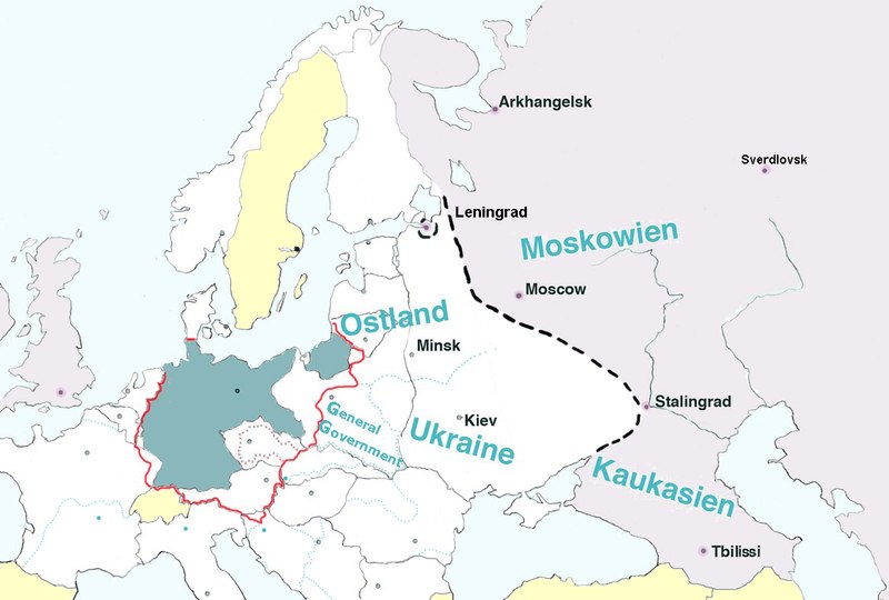
German-inspired map with Nazi-specified borders, 1942. Gray-green shade, prewar Germany; inside red lines, area annexed to Germany; white area, German control and German allies; yellow, neutral countries
摘要[编辑]
| 描述 |
English: Map of Europe, with pre-WW2 borders, showing the extension of Nazi Germany's GENERALPLAN OST worked out 1940-1942.
Legend: Blue-green – Germany (Deutsches Reich). Dotted black line – the extension of detailed plans of a second ”phase of settlement” (Siedlungsphase). Light grey – the greatest extension of Generalplan Ost. The names in blue – Nazi regions called Reichskommissariat : Ostland (1941-1945), Ukraine (1941-1945), Moskowien (never realized), Kaukasien (never realized). Yellow – neutral countries. The map is based on texts and graphics on Deutsche Forschungsgemeinschaft: Der Generalplan Ost der Nationalsozialisten, [1] |
||
| 日期 | |||
| 来源 | 自己的作品 | ||
| 作者 | Lihagen | ||
| 授权 (二次使用本文件) |
|
许可协议[编辑]
我,本作品著作权人,特此采用以下许可协议发表本作品:
| 本作品采用知识共享CC0 1.0 通用公有领域贡献许可协议授权。 | |
| 采用本宣告发表本作品的人,已在法律允许的范围内,通过在全世界放弃其对本作品拥有的著作权法规定的所有权利(包括所有相关权利),将本作品贡献至公有领域。您可以复制、修改、传播和表演本作品,将其用于商业目的,无需要求授权。
|
文件历史
点击某个日期/时间查看对应时刻的文件。
| 日期/时间 | 缩略图 | 大小 | 用户 | 备注 | |
|---|---|---|---|---|---|
| 当前 | 2017年2月9日 (四) 17:22 |  | 1,166 × 787(2.63 MB) | Claude Zygiel(留言 | 贡献) | Leningrad |
| 2017年2月9日 (四) 17:18 |  | 1,166 × 787(2.63 MB) | Claude Zygiel(留言 | 贡献) | Sverdlovsk, Tbilissi, borders during the war in green, neutral states in yellow | |
| 2016年7月28日 (四) 17:35 |  | 1,166 × 787(2.63 MB) | Julieta39(留言 | 贡献) | Pre-WW2 borders in grey, Gross-Deutschlands Reich in red, add General-Government | |
| 2011年4月10日 (日) 19:07 |  | 1,166 × 787(2.63 MB) | Lihagen(留言 | 贡献) | {{Information |Description ={{en|1=Map of Europe, with pre-WW2 boarders, showing the extension of Nazi Germany's GENERALPLAN OST. Legend: Dark grey – Germany (Deutsches Reich); Dotted black line – the extension of a second ”phase of resattlemen |
您不可以覆盖此文件。
文件用途
以下3个页面使用本文件:
全域文件用途
以下其他wiki使用此文件:
- ar.wikipedia.org上的用途
- cs.wikipedia.org上的用途
- da.wikipedia.org上的用途
- el.wikipedia.org上的用途
- en.wikipedia.org上的用途
- es.wikipedia.org上的用途
- et.wikipedia.org上的用途
- fr.wikipedia.org上的用途
- he.wikipedia.org上的用途
- id.wikipedia.org上的用途
- it.wikipedia.org上的用途
- ja.wikipedia.org上的用途
- mk.wikipedia.org上的用途
- nl.wikipedia.org上的用途
- no.wikipedia.org上的用途
- ro.wikipedia.org上的用途
- ru.wikipedia.org上的用途
- sh.wikipedia.org上的用途
- sk.wikipedia.org上的用途
- sr.wikipedia.org上的用途
- sv.wikipedia.org上的用途
- uk.wikipedia.org上的用途
- zh.wikipedia.org上的用途