File:Geography of Afghanistan.jpg
Jump to navigation
Jump to search
Size of this preview: 800 × 539 pixels. Other resolutions: 320 × 216 pixels | 640 × 431 pixels | 1,024 × 690 pixels.
Original file (1,024 × 690 pixels, file size: 428 KB, MIME type: image/jpeg)
Captions
Captions
Add a one-line explanation of what this file represents
Summary
[edit]
| Description |
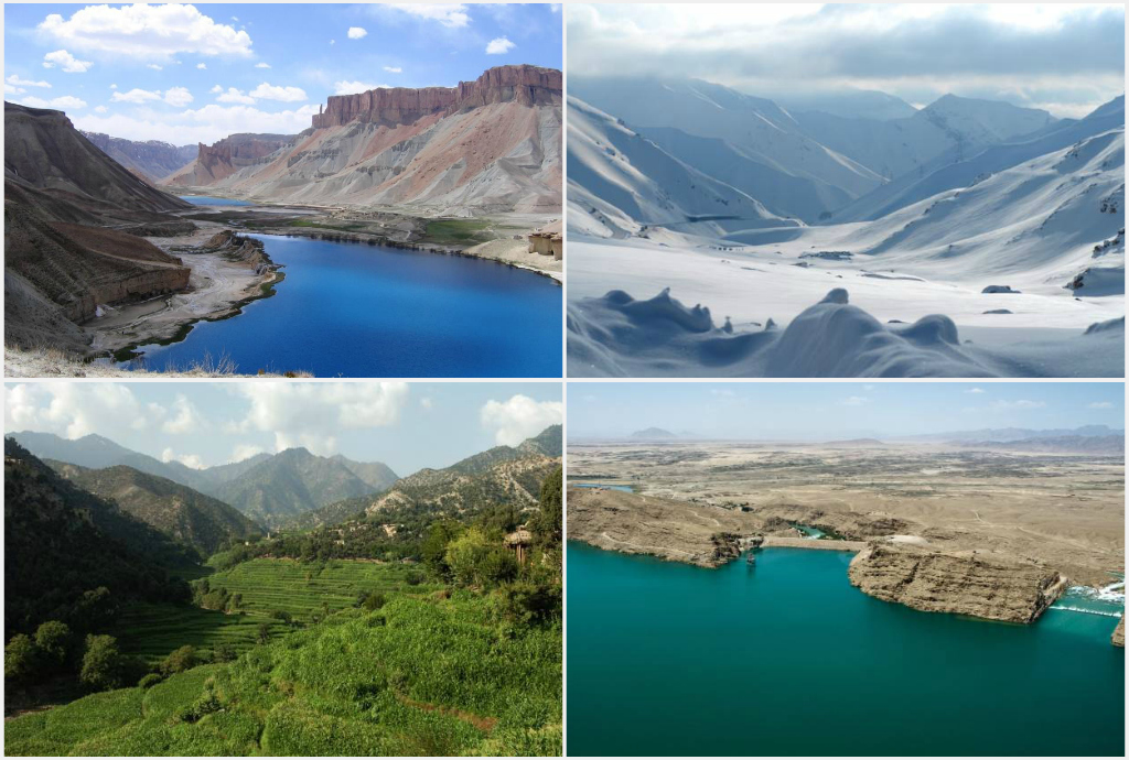
English: Afghanistan collage, from left to right: 1. Band-e Amir National Park in Bamyan province, 2. The Salang Pass in Parwan province, 3. Korengal Valley in Kunar province, 4. Kajaki Dam in Helmand province. |
| Date | |
| Source |
United States Federal Government:
|
| Author | Officer |
Licensing
[edit]
This work is in the public domain in the United States because it is a work prepared by an officer or employee of the United States Government as part of that person’s official duties under the terms of Title 17, Chapter 1, Section 105 of the US Code.
Note: This only applies to original works of the Federal Government and not to the work of any individual U.S. state, territory, commonwealth, county, municipality, or any other subdivision. This template also does not apply to postage stamp designs published by the United States Postal Service since 1978. (See § 313.6(C)(1) of Compendium of U.S. Copyright Office Practices). It also does not apply to certain US coins; see The US Mint Terms of Use.
|
 | |
| This file has been identified as being free of known restrictions under copyright law, including all related and neighboring rights. | ||
File history
Click on a date/time to view the file as it appeared at that time.
| Date/Time | Thumbnail | Dimensions | User | Comment | |
|---|---|---|---|---|---|
| current | 06:36, 18 June 2013 | | 1,024 × 690 (428 KB) | Officer (talk | contribs) | {{Information |Description={{en|1=Afghanistan collage, from left to right: 1. Band-e Amir National Park in Bamyan province, 2. The Salang Pass in Parwan province, 3. Korengal Valley in Kunar province, 4. Kajaki Dam in Helmand province.}} |Source=United... |
You cannot overwrite this file.
File usage on Commons
There are no pages that use this file.
File usage on other wikis
The following other wikis use this file:
- Usage on cs.wikipedia.org
- Usage on de.wikipedia.org
- Usage on en.wikipedia.org
- Usage on eo.wikipedia.org
- Usage on es.wikipedia.org
- Usage on fa.wikipedia.org
- Usage on fr.wikipedia.org
- Usage on hy.wikipedia.org
- Usage on hyw.wikipedia.org
- Usage on incubator.wikimedia.org
- Usage on ms.wikipedia.org
- Usage on pl.wikivoyage.org
- Usage on ta.wikipedia.org
- Usage on uk.wikipedia.org
- Usage on uz.wikipedia.org
- Usage on vi.wikipedia.org