File:Geol British isles-fr.png
Jump to navigation
Jump to search

Size of this preview: 348 × 599 pixels. Other resolutions: 139 × 240 pixels | 279 × 480 pixels | 754 × 1,297 pixels.
Original file (754 × 1,297 pixels, file size: 805 KB, MIME type: image/png)
Captions
Captions
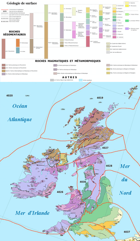
Geological map of British Isles (fr.)
Summary
[edit]
| Description |
English: Geological map of British Isles (fr.), part of Eric Gaba's File:Europe geological map-fr.jpg |
||
| Date | |||
| Source | USGS (public domain for the part of the data used) and International political boundaries and additional coastlines: NGDC World Coast Line (public domain) | ||
| Author |
Eric Gaba (Sting -
|
Licensing
[edit]
This file is licensed under the Creative Commons Attribution-Share Alike 4.0 International license.
- You are free:
- to share – to copy, distribute and transmit the work
- to remix – to adapt the work
- Under the following conditions:
- attribution – You must give appropriate credit, provide a link to the license, and indicate if changes were made. You may do so in any reasonable manner, but not in any way that suggests the licensor endorses you or your use.
- share alike – If you remix, transform, or build upon the material, you must distribute your contributions under the same or compatible license as the original.
File history
Click on a date/time to view the file as it appeared at that time.
| Date/Time | Thumbnail | Dimensions | User | Comment | |
|---|---|---|---|---|---|
| current | 16:58, 13 November 2022 | | 754 × 1,297 (805 KB) | Romain Lemoine (talk | contribs) | Uploaded a work by Eric Gaba (Sting - {{User:Sting/Credits|type=map}} August 2010 from [http://pubs.usgs.gov/of/1997/ofr-97-470/OF97-470I/index.htm USGS] (public domain for the part of the data used) and International political boundaries and additional coastlines: NGDC World Coast Line (public domain) with UploadWizard |
You cannot overwrite this file.
File usage on Commons
There are no pages that use this file.
File usage on other wikis
The following other wikis use this file:
- Usage on fr.wikipedia.org