File:Geological map Britain William Smith 1815.jpg
跳转到导航
跳转到搜索
本预览的尺寸:407 × 600像素。 其他分辨率:163 × 240像素 | 325 × 480像素 | 521 × 768像素 | 1,200 × 1,769像素。
原始文件 (1,200 × 1,769像素,文件大小:456 KB,MIME类型:image/jpeg)
说明
说明
添加一行文字以描述该文件所表现的内容
| 描述 |
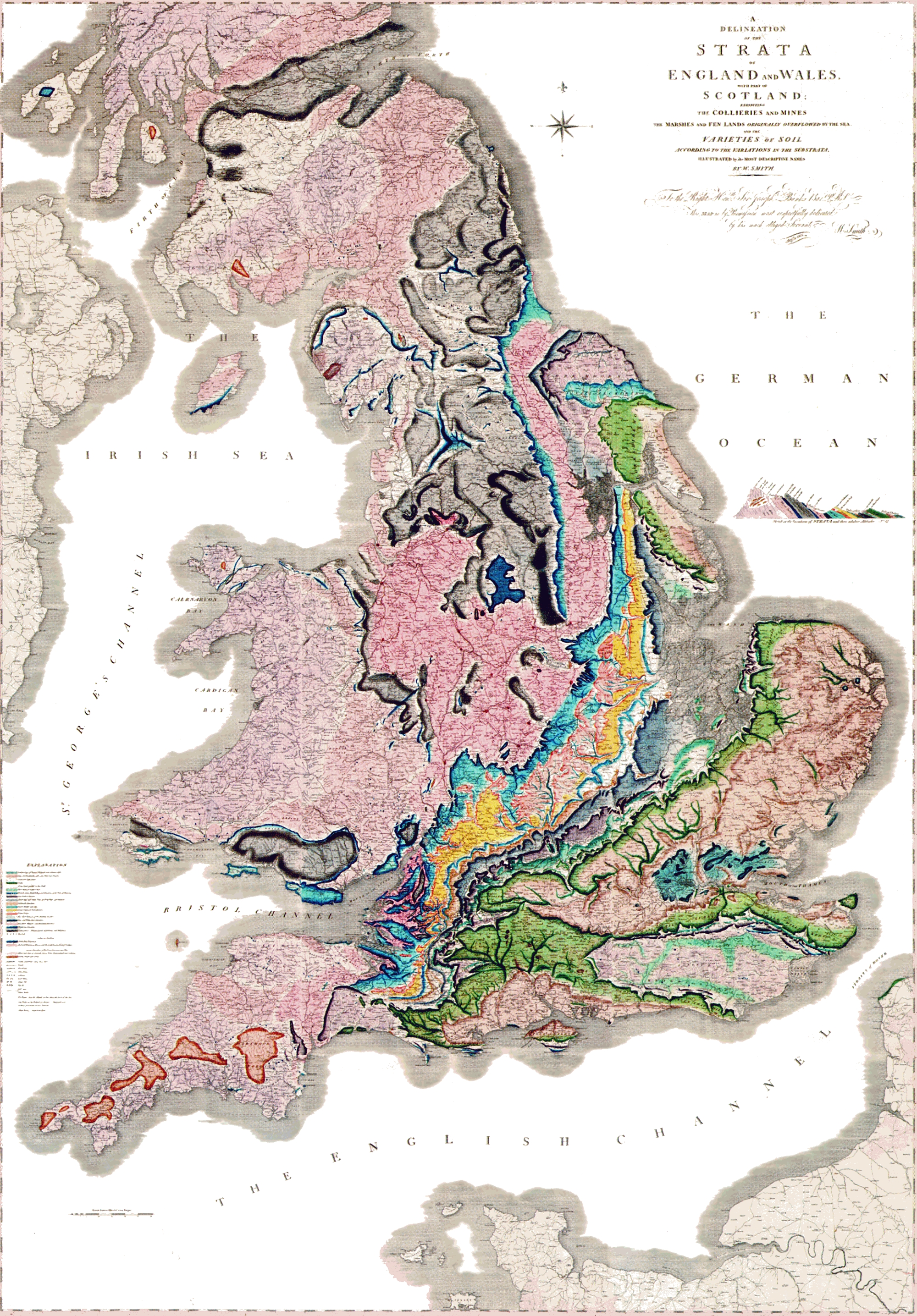
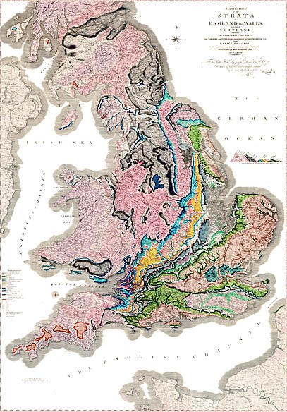
A delineation of the strata of England and Wales with part of Scotland. (The first geological map of Britain, published by William Smith in 1815) |
|||||
| 日期 | ||||||
| 来源 |
未知 العربية: خريطةُ وليام سميث الجيولوجية لإنجلترا وويلز وجنوب اسكتلندا، والتي تم الانتهاء منها في عام 1815م، وتُعتبر ثاني خريطة جيولوجيّة على النطاق الوطني، وكانت أدقَّ خريطةٍ في وقتها |
|||||
| 作者 | William Smith (1769-1839) | |||||
| 授权 (二次使用本文件) |
|
|||||

文件历史
点击某个日期/时间查看对应时刻的文件。
| 日期/时间 | 缩略图 | 大小 | 用户 | 备注 | |
|---|---|---|---|---|---|
| 当前 | 2024年5月29日 (三) 21:03 | | 1,200 × 1,769(456 KB) | Anticline(留言 | 贡献) | Reverted to version as of 00:45, 11 December 2008 (UTC) as this image more accurately reflects the colouring and appearance of the map |
| 2014年10月20日 (一) 14:45 |  | 2,000 × 2,871(4.63 MB) | Ivtorov(留言 | 贡献) | edited colors, crop. | |
| 2008年12月11日 (四) 00:45 |  | 1,200 × 1,769(456 KB) | Gump Stump(留言 | 贡献) | {{Information |Description=The first geological map of Britain, published by William Smith in 1815. |Source=[http://www.livescience.com/php/multimedia/imagedisplay/img_display.php?pic=051031_first_map_02.jpg LiveScience Image Gallery] Scan by the Library |
您不可以覆盖此文件。
文件用途
以下2个页面使用本文件:
全域文件用途
以下其他wiki使用此文件:
- ar.wikipedia.org上的用途
- bg.wikipedia.org上的用途
- bn.wikipedia.org上的用途
- ca.wikipedia.org上的用途
- de.wikipedia.org上的用途
- en.wikipedia.org上的用途
- es.wikipedia.org上的用途
- fr.wikipedia.org上的用途
- fy.wikipedia.org上的用途
- gl.wikipedia.org上的用途
- he.wikipedia.org上的用途
- hy.wikipedia.org上的用途
- it.wikipedia.org上的用途
- ja.wikipedia.org上的用途
- ka.wikipedia.org上的用途
查看此文件的更多全域用途。